


Akeld
Akeld is a Village in the county of Northumberland.
There are great places to visit near Akeld including some great villages, ancient sites, beaches, hiking areas, geological features, castles, ruins, islands, towns, roman sites and historic monuments.
The area around Akeld features a number of interesting villages including Milfield, Craster, and Bamburgh.
The area around Akeld's best ancient sites can be found at Milfield North Henge.
There are a several good beaches in the Akeld area like Embleton Bay, and Bamburgh Beach.
Dunstanburgh, Sycamore Gap, and Hadrian's Wall near Hexham are some of Akeld best hiking areas to visit near Akeld.
There are a several good geological features in the Akeld area like Gull Crag and the Rumble Churn, Greymare Rock, and Sycamore Gap.
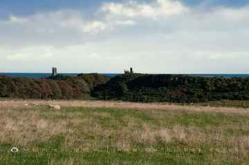
There are a number of castles near to Akeld including Dunstanburgh Castle.
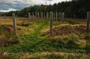
There are a several good ruins in the Akeld area like Dunstanburgh Castle, WWII Sandbag Pillbox, and Old Limekiln at Dunstanburgh.
The area around Akeld's best islands can be found at Farne Islands.
The area around Akeld features a number of interesting towns including Hexham, and Berwick-upon-Tweed.
There are a several good roman sites in the Akeld area like Hadrian's Wall near Hexham, and Chesters Roman Fort.
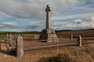
Akeld is near some unmissable historic monuments like Flodden,
Akeld History
There are some historic monuments around Akeld:
- Two camps and cup and ring marked rocks on Dod Law
- Iron Age defended settlement and cultivation terraces 600m north east of Brown's Law Cottage
- Romano-British farmstead 630m south west of White Gables
- Roman period native homestead 400m south of Humbleton Hill hillfort
- Weetwood Bridge
- Roman period native settlement 400m WSW of Carey Burn Bridge
- Site E of Milfield village
- South Ringles Roman period native settlement 850m north west of Middleton Dean
- Roman period native settlement and medieval shieling on east slopes of Brands Hill, 1100m south east of Carey Burn Bridge
- Chesters Strip Plantation earthwork near Fenton House, Nesbit
- Wooler Tower on east side of Church Street
- Castle Hill camp
- Prehistoric unenclosed hut circle settlement west of Monday Cleugh, 520m SSE of Gleadscleugh
- Bronze Age unenclosed hut circle settlement, field system and cairnfield, 630m south west of triangulation point on Gains Law
- Prehistoric enclosures, Bronze Age field system, unenclosed round houses and three cairns NW of Langlee Crags, 900m south of Langlee
- Roman period native farmstead and associated scooped enclosures and trackways on east slope of Harehope Hill, 925m south east of High Akeld Cottages
- Unenclosed scooped settlement on the east slope of Harehope Hill, 750m south east of High Akeld Cottages
- Cairnfield 420m south east of triangulation point on Gains Law
- Defended settlement 900m west of Calder
- Settlement on north east slope of Yeavering Bell
- Enclosed settlement on east slope of Brands Hill, 900m north of Cowboy's Cairn
- Prehistoric unenclosed hut circle and field plot at Lamb Crag
- Parson's Tower
- Coupland henge and section of droveway, 170m SSW of Cheviot Cottage
- Ad Gefrin Anglo-Saxon township and prehistoric remains
- Site SW of Thirlings
- Prehistoric unenclosed hut circle settlement, field system and cairnfield 340m south west of triangulation point on Gains Law
- Henge, pit-circle and later cemetery, 850m north east of Millfield Hill
- Round cairn on the southern slope of Dod Hill, 800m NNE of The Dod
- Henge 600yds (550m) E of Akeld Lodge
- Rock art on Weetwood Moor, 702m north east of Wooler Post Office Radio Station
- Cup and ring marked rocks near Roughting Linn camp
- Roman period native settlement on the south east slopes of Brands Hill, 430m north west of Cowboy's Cairn
- Unenclosed stone hut circle settlement 120m north west of Gleadscleugh
- Group of burial mounds on Doddington North Moor
- Roman period native settlement 750m north west of Carey Burn Bridge
- Medieval shieling and enclosure 340m north west of Gleadscleugh
- Long cairn on the south western slope of Dod Hill, 1km north east of The Dod
- Two incised rocks on Broom Ridge, Hunter's Moor
- Incised rock on Hare Crags
- Prehistoric rock art, 92m south west of Buttony
- Two medieval shielings on Akeld Hill, 680m WNW of Gleadscleugh
- Roman period native enclosed settlement 360m south east of Broadstruther
- Multivallate hillfort, at Fenton Hill
- Defended settlement on north slope of Harehope Hill, 570m south east of High Akled Cottages
- The Battle Stone, 650m WNW of Yeavering Farm
- Two prehistoric enclosures, field clearance cairns and unenclosed hut circle settlement north of Hart Heugh, 600m south west of Wooler Common
- Defended settlement, 380m south west of Sandy House
- Standing Stones camp, Horton Moor
- Round cairn 100m south of Torleehouse
- Roman period native settlement, associated field system and trackway, and medieval farmstead 270m south of Torleehouse
- Three round cairns on the summit of Dod Hill
- Bastle House
- Unenclosed hut circle settlement and field plots east of Rackside, 450m south west of Cowboy's Cairn
- Prehistoric enclosed settlement, Iron Age hillfort and medieval shielings on Humbleton Hill
- St Gregory's Hill camp
- Rock art at Goatscrag, 200m north west of Routin Lynn
- Prehistoric cairnfield and unenclosed settlement, Romano-British village and field system and medieval field system on north east slopes of Brands Hill
- Roman period native settlement 340m east of Hethpool Linn
- Stone circle and stone alignment 370m west of Threestoneburn House
- Circular enclosure W of Second Linthaugh
- Coldmartin Tower, 260m north east of Tower Martin
- Glead's Cleugh Iron Age promontory fort
- Prehistoric enclosure south west of Brands Hill and 870m east of Langlee
- Flodden camp
- Two Bronze Age round cairns and enclosed cremation cemetery 825m north west of Middleton Dean
- Bronze Age round cairn on summit of Hart Heugh, 780m south west of Earlehillhead
- Ford Westfield settlement
- Romano-British farmstead on the eastern slope of Dod Hill, 1km north of The Dod
- Romano British settlement, 655m north east of Lanton Hill Monument
- Hut circle 770m south east of White Gables
- Romano-British settlements E of Yeavering Bell containing the Old Sheepfold settlement and settlements to the W and S of it
- West Hill camp
- Bronze Age field system on Fredden Hill
- The Kettles univallate hillfort and enclosed settlement, 261m north west and 331m south west of King's Chair
- Settlement, probably medieval, SW of Torleehouse
- Prehistoric field system and cairnfield east of Watch Hill, 520m NNE of footbridge over Carey Burn
- Round cairn 435m south west of Langlee
- Hazely Hill round cairn
- Prehistoric field system and unenclosed hut circle settlement on eastern slopes of Hart Heugh, 550m south west of Earlehillhead
- Settlement on the east slope of The Bell
- North Middleton medieval village
- Settlement, field systems and terraces on the south east slope of Yeavering Bell
- Iron Age multivallate hillfort and prehistoric trackway at Monday Cleugh
- Incised rocks on Gled Law
- Prehistoric hut circle on Harehope Hill, 400m south east of Gleadscleugh
- Roman period native settlement and associated field system and trackway on north east slope of Brands Hill
- The Ringses multivallate hillfort, Doddington Moor
- Round cairn 760m south east of triangulation point on Gains Law
- Tathey Crags prehistoric unenclosed hut circle settlement
- Romano-British farmstead 900m north east of triangulation point on Gains Law
- Roman period native settlements, field system and medieval shieling on the east slope of Brands Hill, 550m west of Middleton Old Town
- Two pillboxes near Green Castle
- Bronze Age cairnfield and cup and ring marked stone 550m north west of Middleton Dean
- Promontory fort 330m south east of Middleton Dean
- Roman period native farmstead north west of Long Crags, 600m south east of Langleeford
- Settlements SE of Heddon Hill
- Medieval shieling and enclosure 330m south west of Langlee
- Roman period native scooped enclosure, 930m north east of Langlee
- Medieval chapel, 220m south east of White Gables
- Prehistoric unenclosed hut circle settlement and field system on Snear Hill, 700m west of the western edge of Coronation Wood
- Two Roman period native settlements and associated field system on Coldberry Hill
- Round cairn 790m west of Smithy Strip
- Roughting Linn camp
- Ford Colliery 920m north east of Blackcrag Wood
- Prehistoric unenclosed hut circle settlement south east of Long Crags
- Green Castle ringwork 320m south west of Humbleton Mill
- Settlement on north slope of Yeavering Bell
- Howtel tower house
- Defended settlement on White Hill, 700m south east of Kimmerston
- The standing stones on Doddington Moor
- Roman period native enclosed settlement and medieval sheiling 165m north east of Dunsdale
- Unenclosed hut circle settlement 1060m north west of Ilderton Moor
- Unenclosed Bronze Age hut circle and clearance cairn 800m ESE of Langlee
- Cairnfield 400m north of Threestoneburn House
- Ewart Park henge
- Settlement 500yds (460m) SW of White Law
- Camp 400yds (370m) NNE of Flodden
- Medieval shieling 600m south east of South Middleton
- Hethpool tower house
- Romano-British settlement 810m south east of Whitehall
- Buttony Wood camp, Horton Moor
- Three Romano-British farmsteads and part of a field system on Heddon Hill 900m north west of Calder
- Settlement at the south end of The Bell
- Round cairn on the summit of Heddon Hill
- Prehistoric field system, cairnfield, round cairns and enclosed cremation cemetery on east slopes of Fredden Hill, 750m west of Wooler Common
- Roman period native enclosed settlement and scooped enclosure on the south east slopes of Brands Hill, 350m north west of Cowboy's Cairn
- Iron Age defended settlement 740m south east of South Middleton
- Flodden Edge camp
- Two prehistoric hut circles and field enclosure 560m south west of Cowboy's Cairn
- Defended settlement, 400m south west of Nesbit
- Prehistoric hut circle 540m south of Gleadscleugh
- Incised rocks 550yds (500m) NW of Doddington Dean Wood
- Romano-British native farmstead 970m north east of triangulation point on Gains Law
- Round cairn cemetery 1000m north west of Heddon Hill
- Yeavering Bell camp
- Rock art on Weetwood Moor, 1km south west of Clavering
- Three Roman period native settlements and later droveway 750m south west of Torleehouse
- Bronze Age cairnfield on north west slopes of Hart Heugh, 900m south west of Wooler Common
- Bronze Age unenclosed settlement and field system with burial cairns south west of Brands Hill, 350m ENE of Langlee
- Site SE of Yeavering
- Farmstead and cultivation terraces, ENE of Stawhouse
- Enclosed settlement and subsidiary enclosure on east slope of Brands Hill, 700m south west of the south western edge of Broom Crook Plantation
- Prehistoric enclosure, associated field system, cairnfield, round houses and medieval shielings on E and SE slopes of Brands Hill
- The Battle Stone
- Enclosed settlement 920m south east of Whitehall
- Unenclosed hut circle settlement and part of a field system, 880m north of Heddon Hill
- Romano-British farmstead and part of an associated field system 630m south west of White Gables
- Prehistoric rock art 190m south west of Middleton Dean promontory fort
- Etal Castle tower house
- Settlement 470m north east of Heddon Hill
- The Ringles defended settlement 1025m north west of Middleton Dean
- Hut circle 320m west of Threestoneburn House
- Fordwood camp, Broomridge Dean
- Round cairn 850m, and two Romano-British farmsteads, associated trackway, moated site, medieval settlement and field system 900m SSE of Middleton Dean
- Rock art 350m east of The Ringses hillfort
- Weetwood Bank cup and ring marked rock, 290m north west of Wooler Post Office Radio Station
- Weetwood Moor round cairns
- Bronze Age round house on Fredden Hill 880m south west of Bell's Valley
- Prehistoric rock art, 225m east of Whitsunbank Hill
- Roman period native settlement on south eastern slope of Hart Heugh, 490m north west of Carey Burn Bridge
- Rock art including four animal carvings at Goatscrag rock shelter, 155m north west of Routin Lynn
- Settlement N of White Law
- Marley Knowe round cairn
Places to see near Akeld


Lakes near Akeld
Rivers near Akeld
- Otter Burn Catchment (trib of Rede)
- Rede from Source to Cottonshope Burn
- Sills Burn Catchment (trib of Rede)
- Cottonshope Burn Catchment (trib of Rede)
- Durtrees Burn Catchment (trib of Rede)
- Wind Burn Catchment (trib of Rede)
- Rede from Bellshiel Burn to N Tyne
- Rede from Cottonshope Burn to Bellshiel Burn
- Elsdon Burn Upper Catchment East
- Lisles Burn Catchment (trib of Rede)
- Elsdon Burn Upper Catchment West
- Dargues Burn Catchment (trib of Rede)
- Blakehope Burn Catchment (trib of Rede)
- Miller Burn Catchment (trib of Rede)
- Elsdon Burn lower catchment (Trib of Rede)
- West Allen from Source to Wellhope Burn
- Allen from West Allen to South Tyne
- West Allen from Wellhope Burn to Allen
- Carr's Burn Catchment (Trib of West Allen)
- Wellhope Burn Catchment (Trib of West Allen)
- Allen from Source to West Allen
- Chevington Burn/Steads Burn from Source to Tidal Limit
- Lyne from Source to Tidal Limit
- Coquet from Usway Burn to Holystone Burn
- Black Burn Catchment (trib of Wreigh Burn)
- Holystone Burn Catchment (trib of Coquet)
- Usway Burn from Source to Coquet
- Foxton Burn Catchment (trib of Wreigh Burn)
- Coquet from Source to Usway Burn
- Alwin Catchment (trib of Coquet)
- Netherton Burn Catch (trib of Wreigh Burn)
- Wreigh Burn from Netherton Burn to Coquet
- Ridlees Burn from Source to Coquet
- Wreigh Burn from Source to Netherton Burn
- Grasslees Burn
- Barrow Burn Catchment (trib of Coquet)
- Edlingham Burn from Source to Aln
- Aln from Edlingham Burn to Tidal Limit
- Aln from Source to Callaly Burn
- Cawledge Burn Catchment (trib of Aln)
- Callaly Burn Catchment (trib of Aln)
- Aln and Shawdon Burn from Coe Burn to Edlingham Burn
- Shipley Burn from Source to Aln
- Eglingham Burn from Source to Shipley Burn
- Coe Burn Catchment (trib of Aln)
- Aln from Callaly Burn to Coe Burn
- Pont from Fenwick Burn to Med Burn
- Fenwick Burn from Source to Pont
- Pont from Small Burn to Blyth
- Blyth from How Burn to Pont
- Ponteland to Dinnington Catchment Area
- Blyth from Source to How Burn
- Coldcoats Burn Catchment (trib of Pont)
- Pont from Med Burn to Small Burn
- Pont from Source to Fenwick Burn
- Med Burn from Source to Pont
- How Burn from Source to Blyth
- Ogle Burn Catchment (trib of Blyth)
- Hart Burn from Source to Delf Burn
- Delf Burn Catchment (trib of Hart Burn)
- Wansbeck from Ray Burn to Hart Burn
- Wansbeck from Bothal Burn to North Sea
- Hart Burn from Delf Burn to Wansbeck
- Wansbeck from Source to Ray Burn
- Bothal Burn Catchment (trib of Wansbeck)
- Wansbeck from Font to Bothal Burn
- Ray Burn Catchment (trib of Wansbeck)
- Wansbeck from Hart Burn to Font
- Font from Source to Wansbeck
- Todd Burn Catchment (trib of Coquet)
- Hazon Burn Catchment (trib of Coquet)
- Coquet from Forest Burn to Tidal Limit
- Forest Burn Catchment (trib of Coquet)
- Coquet from Holystone Burn to Forest Burn
- Black Burn Catchment (trib of Coquet)
- Tyelaw Burn Catchment (trib of Coquet)
- Longdike Burn Catchment (trib of Coquet)
- Swarland Burn Catchment (trib of Coquet)
- Blyth from Pont to Tidal Limit
- Duddo Burn from Source to Blyth
- Seaton Burn from Source to Tidal Limit
- Sleek Burn / Hepscott Burn Source to Tidal Limit
- South Low from Haggerston Bridge to N Sea
- Waren Burn from Source to N Sea
- North Low from Source to Berrington Burn
- Annstead Burn from Source to N Sea
- Rennington Burn from Source to N Sea
- Embleton Burn form Source to N Sea
- Brunton burn from Source to N Sea
- Newlands Burn Catchment (trib of Waren Burn)
- South Low from Source to Haggerston Bridge
- Berrington Burn from Source to North Low
- Elwick Burn from Source to Ross Low
- Ross Low from Source to Eldwick Burn
- Fenham Burn Catchment (to N Sea)
- Belford Burn from Source to Ross Low
- Long Nanny from Source to N Sea
- North Low from Berrington Burn to N Sea
- Newbiggin Dean Catch (trib of Tweed)
- Horncliffe Mill Burn
- Willow Burn Catchment (Trib of Tweed)
- Till from Roddam Burn to Glen
- Glen from Source to College Burn
- Till from Linhope Burn to Roddam Burn
- Till from Glen to River Tweed
- Glen from College Burn to Till
- College Burn from Lambden Burn to Glen
- Harthope Burn
- Till (Nthumb)
- Pallins Burn Catch (trib of Till)
- Lambden Burn from Source to College Burn
- Lilburn Burn
- College Burn from Source to Lambden Burn
- Wooler Water from Harthope Burn to Till
- Wooler Water from Source to Harthope Burn
- Linhope Burn from Source to Till
- Roddam Burn
- Till from Source to Linhope Burn
- Hetton Burn


