Chesters Roman Fort by Hannah Blundell
Chesters Roman Fort
The section of frontier Roman occupation in the north, which includes Chesters fort (known to the Romans as Cilurnum) occupies a broad stretch of river terrace on the west bank of the North Tyne.
Hadrian’s Wall is visible intermittently as an upstanding feature in this section. Short sections of wall are upstanding at the junctions with the fort on the south sides of the east and west gateways.
There is a length of consolidated Wall to the east of the fort which is in the care of the Secretary of State. West of the fort the wall line is denoted by a mound up to 40 centimetres in height. There are no visible upstanding remains west of the ha-ha, which formed an element of the landscape gardens of Chester House.
The wall ditch is discernible to the east of the fort as a ploughed down upcast scarp. For the most part it survives as a silted up feature below the surface. To the west of the fort the ditch survives as a discontinuous depression.
Turret 27a which occupied part of the site before the fort was built was discovered by excavation in 1945. Turret 27a was found to lie about 42 metres west of the inner face of the east gateway.
The bridge abutments and piers which carried the Hadrian’s Wall and Military Way over the River North Tyne survive well as upstanding monuments. These features are now consolidated and in the care of the Secretary of State. There is also a section of consolidated wall and tower base adjoining the east bridge abutment on its west side.
Excavations of the abutments by Bidwell and Holbrook in 1990 have shown that there were two clear phases to the bridge - the early Hadrianic structure, and the larger and more imposing one of third century.
The precise location of the vallum around Chesters has not yet been confirmed. Aerial photographs show the possible start of it from near the west bank of the North Tyne, but around the fort the course is conjectural.
The course of the Roman road known as the Military Way, which ran along the corridor between Hadrian s Wall and the vallum linking turrets, milecastles and forts, survives well in the section between the North Tyne and the fort. The line of the road is clearly defined on the ground leaving the fort by the east gateway and heading towards the Roman bridge. Initially it is a depression and then becomes a causeway with a maximum height of 80 centimetres, with a kerb to the south visible for 1.3 metres. There are no upstanding remains of the road to the west of the fort. However, the antiquarian Horsley considered that the Military Way exited Chesters and then converged gradually with the north mound of the vallum where they continued united for a considerable distance.
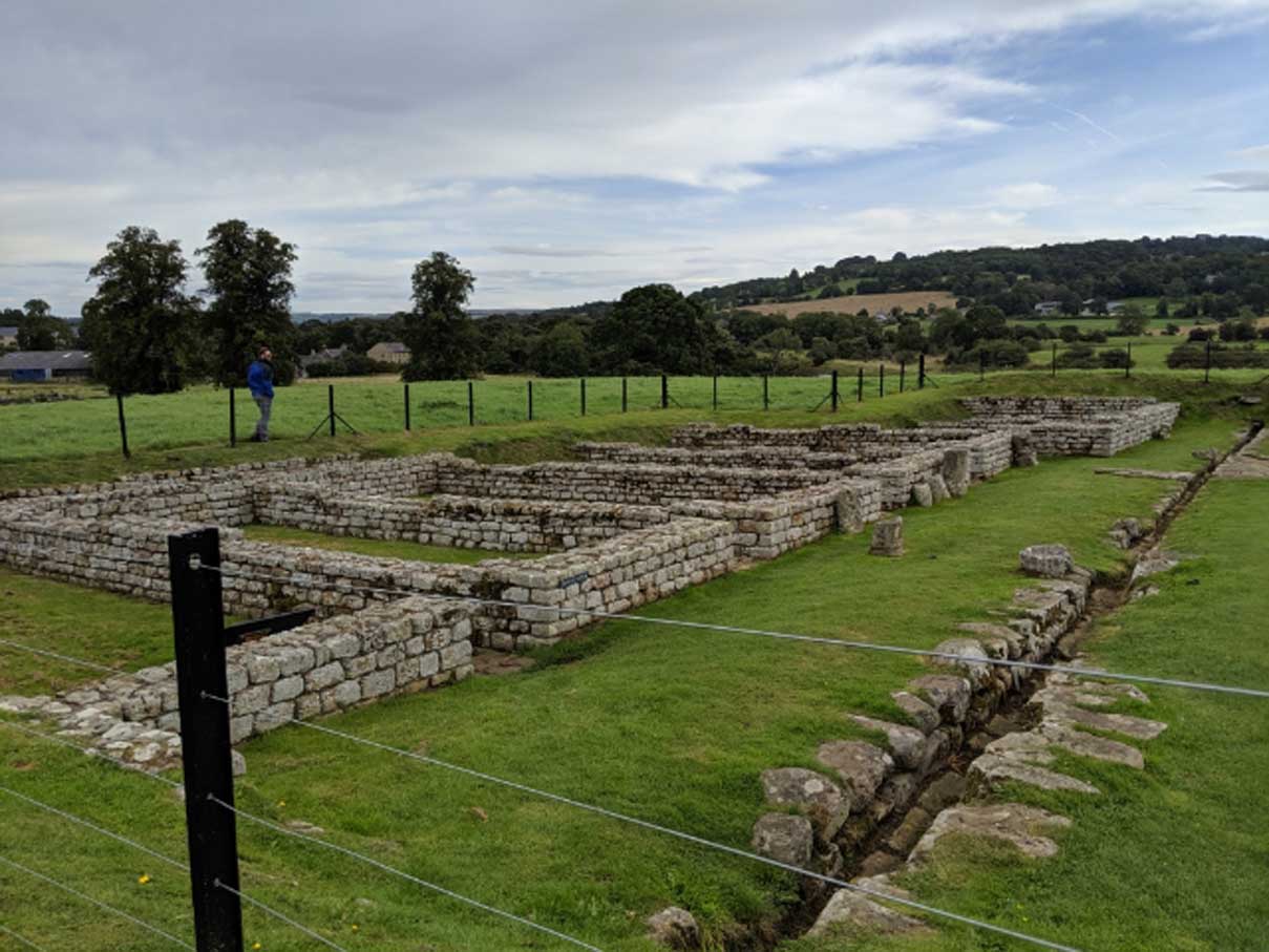
The Roman fort at Chesters, was built to guard the North Tyne crossing of Hadrian’s Wall. Excavation has demonstrated that the fort was constructed after, and overlies, the wall.
The upstanding masonry is best preserved in the south east corner where it survives to a height of 1.9 metres. Well preserved visible remains in the interior include the consolidated remains of the headquarters building, commanding officer’s house and some barrack blocks. Buried remains will survive below the ridge and furrow cultivation inside the fort.
Chesters Roman Fort has been excavated at various times from 1796 up to the most recent investigations in 1990 and 1991. Extensive earthworks within the fort probably show the position of the backfilled trenches and spoilheaps, resulting from the various excavations.
An extensive civil settlement, or vicus, is located outside the fort on the south side. It occupies an area of level ground bordered to the east by the steep cliff down to the river’s edge. Its buildings and roads are known largely from the evidence of aerial photographs.
The settlement is orientated around the road leading south from the fort and a road which bisects it at right angles. A well, believed to be Roman, survives as an upstanding feature immediately outside the garden of Chesters house.
The well preserved remains of a bath house are visible to the east of the fort about 30 mertres uphill from the present course of the river. It had a paved floor, hypocaust and an outflow drain, as well as various hot and cold rooms. An interesting and unique feature of this bath house is that when it was discovered in the 1880s, the remains of 33 human skeletons, two horses and a dog were found. There is a however some doubt as to exactly where around the bath house they were found.
A quantity of monumental masonry has been found by the river at the point where the ha-ha wall joins its bank, suggesting that this was the location of the cemetery. More recently an altar has been found in the river bank closer to the fort together with a fragment of architectural masonry.
A road runs from the south gateway of the fort to the Stanegate Roman road which lies further south. Aerial photography has shown that this road runs along the crest of the river bank south of the ha-ha wall.
Created: 4 July 2021 Edited: 29 November 2023
Chesters Roman Fort and Museum Information
Chesters Roman Fort and Museum Address
B6318, Chollerford, Hexham
NE46 4EU
Website: https://www.english-heritage.org.uk/visit/places/chesters-roman-fort-and-museum-hadrians-wall/
Get directionsLocal History around Chesters Roman Fort
There are some historic monuments around including:
Romano-British farmstead and earlier palisaded settlement, 800m SSE of Bridge HouseLimestone Corner Roman temporary campTwo round cairns, 220m south west of Pittland HillsBastle immediately east of MortleyCoesike East Roman temporary campRomano-British farmstead, 400m north-east of SharpleyRomano-British farmstead, 500m north of WatergateHadrian's Wall and vallum between the road to Simonburn and the field boundary east of Carrawburgh car park in wall miles 29, 30 and 31Chipchase TowerPrehistoric rock art west of Middle HouseGoodwife's Hut Romano-British settlement, 310m WNW of South FarmRomano-British farmstead, 300m north of ButelandHut circle, 420m north west of High Carry HouseMedieval wayside cross, 300m west of Bridge HouseHadrian's Wall and vallum between the field boundary west of Coventina's Well and the field boundary at Brown Dikes in wall miles 31 and 32Grindon School Roman temporary campHadrian's Wall and vallum between the field boundary at Brown Dikes and the field boundary east of turret 34a in wall miles 32, 33 and 34Hadrian's Wall and vallum between Chesters and the road to Simonburn in wall miles 27, 28 and 29Carrawburgh Roman fort and Hadrian's Wall and vallum between the field boundary east of the fort and the field boundary west of Coventina's Well in wall mile 31Round cairn, 1.36km west of Middle HouseWalwick Fell Roman temporary campBastle at Horneystead, 400m south west of The AshRound cairn, 1.1km west of Middle HouseMoated site and fishpond, 1km ENE of Sewingshields on Fozy MossCoesike West Roman temporary camps 1 and 2Round cairn, 800m north east of Lowshield GreenRound cairn, 1.34km west of Middle HouseThe Goatstones stone circle, 280m south west of Ravensheugh CragsRound cairn, 300m south of Lowshield GreenHadrian's Wall and associated features between the boundary east of turret 34a and the field boundary west of milecastle 36 in wall miles 34, 35 and 36Romano-British farmstead, 520m north east of Birtley ShieldsRomano-British settlement, 700m north west of The HeughRound cairn, 670m NNE of Middle HouseRoman camp, 290m north west of Seldom SeenFishponds, 450m north-east of SewingshieldsSimonburn Castle tower houseUnenclosed settlement 220m south west of Manor HouseRomano-British settlement, 300m north of The HeughRomano-British farmstead, 210m south east of Walwick FellBrown Moor Roman temporary campRed House Roman campRomano-British farmstead, 400m north east of Hole HouseBrown Dikes Roman temporary camp.


