
St Michael’s Church at Lowther by munki-boy
St Michael’s Church at Lowther
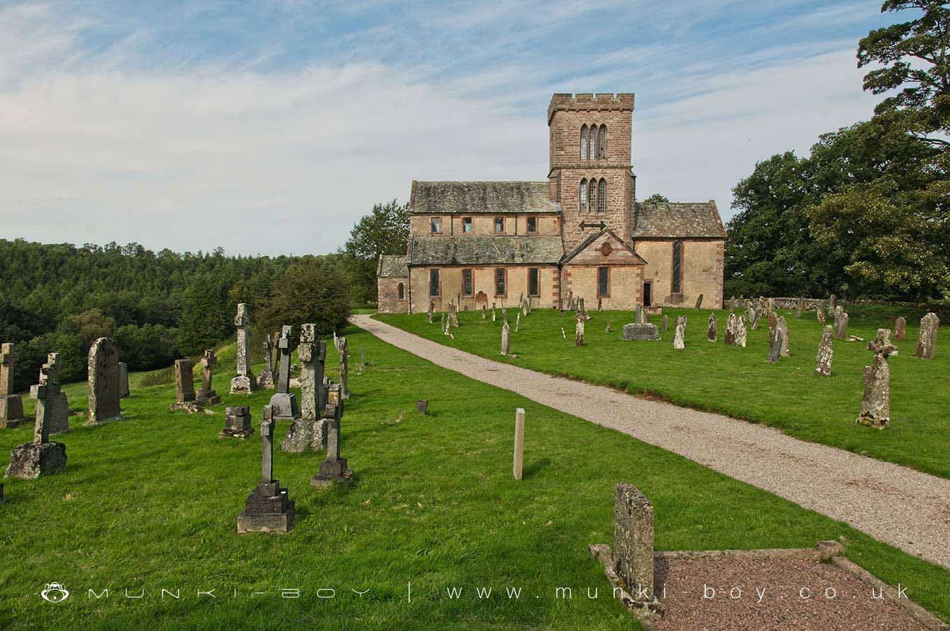
St Michael’s Church at Lowther is in The Lake District National Park in England.
The church of St. Michael at Lowther, twelfth and thirteenth century in origin but rebuilt in the seventeenth century, and completely remodelled in the nineteenth century. It has been suggested as the site of a monastery, but this is unconfirmed.
The listing includes a twelfth century cross and a seventeenth century mounting block in the church grounds, as well the nineteenth century mausoleum for the Lowther family. The late seventeenth century gate piers are also listed.
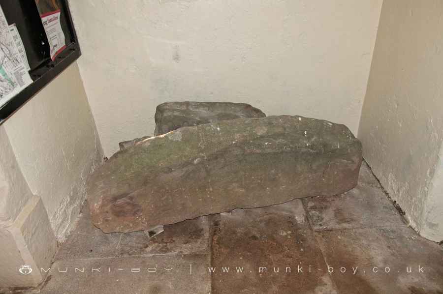
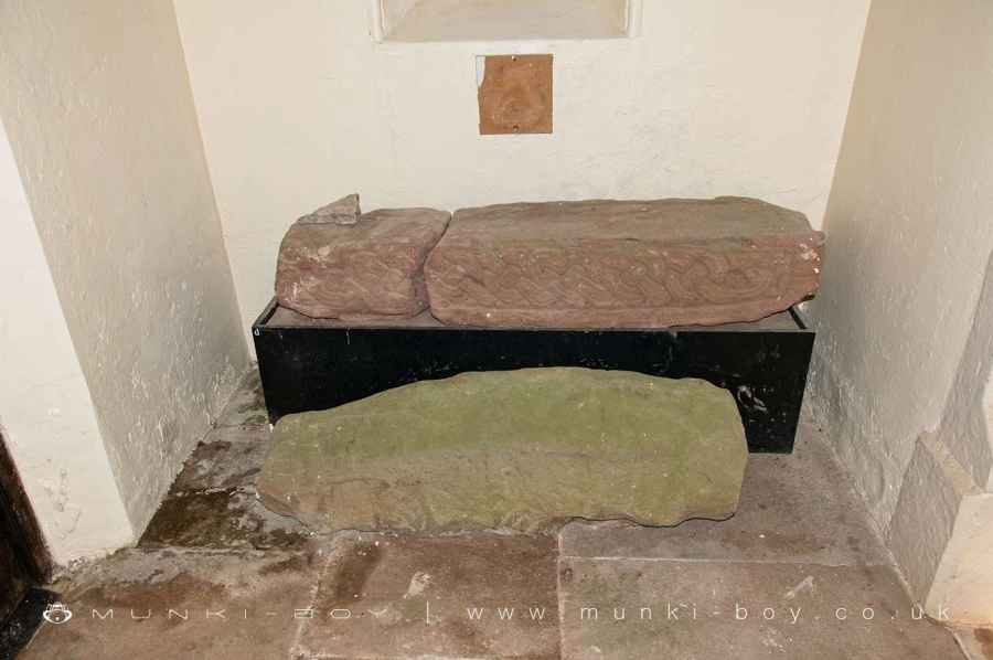
“Three pre-conquest decorated hog-back tombstones are located within the churchyard, and there used to be two cross-shafts inside Lowther Castle, which are probably of eighth century date” (Bailey and Cramp 1984).
The hogback stones and cross parts are now found within the public area of the church.
Church of St Michael, Lowther Park, Askham
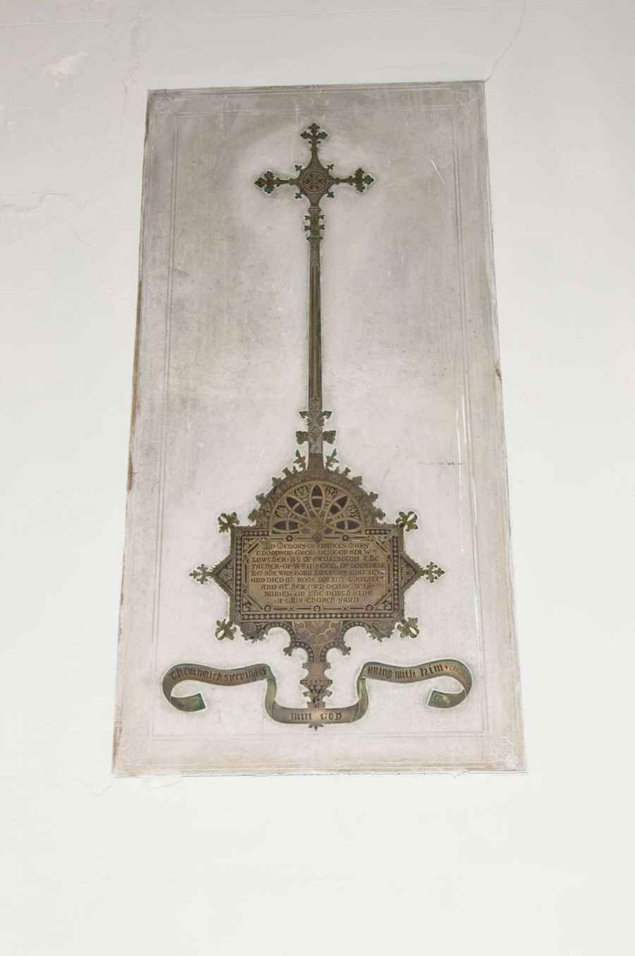
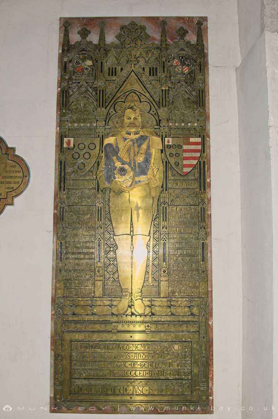
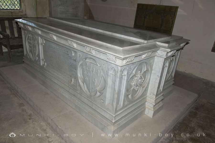
Parish church. C12 and Cl3 with extensive late C17 rebuilding; C19 alterations and additions. Partly-rendered sandstone rubble walls with eaves cornice and raised red sandstone quoins. Graduated greenslate roof with coped gables. 4-bay nave with west porch and aisles; central square 3-storey tower with north and south transepts; single-bay chancel. Nave is externally late C17 with moulded-surround windows in aisles and in clerestory. C19 gabled stone porch. Tower is partly medieval and in late C17 had a domed cupola, removed in C19 and replaced by an extra storey and a battlemented parapet. C19 triple lancet windows. Transepts are late C17, that to south with Lowther arms in pediment. Line of original transept roof can be seen in tower wall above. Chancel has C17 priest’s doorway and tall round-headed windows, 2 in east wall. North vestry. Interior of porch has free-standing remains of 3 hog-back coffin lids and a saxon cross shaft. Interior: north arcade has 3 C12 round piers with carved capitals, supporting round arches. Similar round arches of south arcade are supported by C13 octagonal piers. Font c.1686 inscribed TA. Various marble wall plaques to members of the Lowther family and C20 heraldic stained glass in south windows. Pointed tower arch. Hanoverian Royal Arms of the 3rd period (1816-37) on gallery and pater boards above. In the south transept are elaborate monuments to various members of the Lowther family: an alabaster effigy of Sir Richard Lowther 1608, with accompanying wall-mounted heraldic plaque; John Viscount Lowther 1700, marble effigy and wall plaque; elaborate wall plaque of 2 busts with garlands and railed backdrop to John Lowther and Lord Lowther 1675. More C19 and C20 marble and brass monuments and wall plaques to members of the Lowther family in south transept and in chancel. Dado panelling looks C17 but altar rail is C19 imitating C17. See RCHM, Westmorland, 1936, plates 13, 44, 96 and 138.
Created: 28 October 2020 Edited: 29 November 2023
St Michael’s Church at Lowther
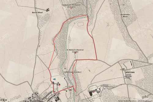
Walks in St Michael’s Church at Lowther
Local History around St Michael’s Church at Lowther
There are some historic monuments around including:
Bowl barrow 80m east of Scarside PlantationMayburgh hengeRound cairn 520m north east of The Cockpit, Askham FellSlight univallate hillfort in Scarside PlantationRound cairn 285m south east of White Raise round cairn, Askham FellRoman road and enclosures SE of FrenchfieldLong cairn 370m ESE of Mossthorn FarmThe Countess PillarCastlesteads multivallate prehistoric defended enclosureRing cairn on Askham Fell including The Cop StoneSt Ninian's preconquest monastic site, site of nucleated medieval settlement, St Ninian's Church and churchyardRound cairn 490m south east of White Raise round cairn, Askham FellRound cairn 50m north east of White Raise round cairn, Askham FellFour funerary cairns and a surrounding cairnfield on Threepow RaiseStone circle 800m east of Wetheriggs PotteryRound cairn 475m south east of White Raise round cairn, Askham FellRound cairn west of Riddingleys Top, Askham FellRing cairn on Askham Fell and four adjacent stonesLittle Round Table hengeThe Cockpit stone circle and seven adjacent clearance cairns, Moor DivockBridge over Heltondale Beck 250yds (230m) SSW of WidewathSkirsgill Romano-British enclosed stone hut circle settlement, Romano-British farmstead, and Romano-British regular aggregate field systemLong cairn 330m east of MossthornTowtop Kirk early Christian enclosureTwo standing stones and a round cairn south of CrooklandsRomano-British settlement and regular aggregate field system north of Yanwath WoodCatterlen Hall tower houseMelkinthorpe medieval settlement, part of its associated open field system and the site of Melkinthorpe HallWhite Raise round cairn, Askham FellRound cairn on Askham Fell, 270m north of The Cop StoneMoated site and annexe east of Setterahpark WoodClifton Hall towerRound cairn 515m south east of White Raise round cairn, Askham FellLong barrow on Trainford BrowRing cairn on Knipescar CommonStrickland's Pele Tower and Penrith CastleRing cairn east of Threepow RaiseRoman marching camp 450yds (410m) NE of BrovacumThe Giant's Thumb - Anglian high cross in St Andrew's churchyard, PenrithSite of Catterlen Old HallThe Old Kiln, Wetheriggs PotteryRound barrow 150m east of Scarside PlantationRound cairn 280m south-east of The Cockpit stone circleSewborrans standing stone 400m south west of SewborwensEamont BridgeSettlement 100yds (90m) SE of Sceugh FarmBowl barrow 350m north east of The WreayBowl barrow 850m WSW of Yanwath Woodhouse FarmRound cairn on Heughscar HillRound cairn 580m north east of The Cockpit, Askham FellRound cairn on Askham Fell, 335m north of the Cop StoneRound cairn 490m ENE of Rough Hill TarnAskham Fell stone alignmentRomano-British settlement at Cragside WoodRound cairn 660m north east of The Cockpit, Askham FellRing cairn on Knipescar Common south of Inscar PlantationSettlement 1/3 mile (540m) ENE of Brougham CastleLinear stone bank on Askham FellBrougham Roman fort (Brocavum) and civil settlement and Brougham CastleStanding stone 180m NNE of SkirsgillMoated site east of Newton ReignyStone bridge, Cawdale BeckBridge over Heltondale Beck 550ft (170m) S of WidewathTwo round cairns 415m and 420m NNE of The Cockpit, Moor DivockKing Arthur's Round Table hengeRound cairn 680m ENE of DalefootThe Giant's Grave - Two Anglian cross-shafts and four hogback stones in St Andrew's churchyard, Penrith.


