Lowther Family Mausoleum by munki-boy
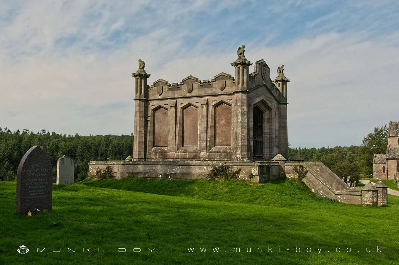
Lowther Mausoleum
Lowther Mausoleum is in The Lake District National Park in England.
Mausoleum for the Lowther family.
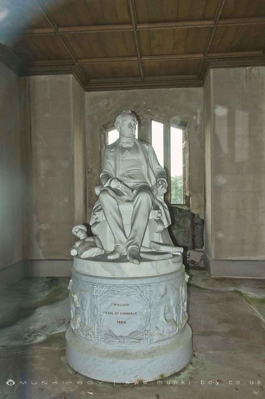
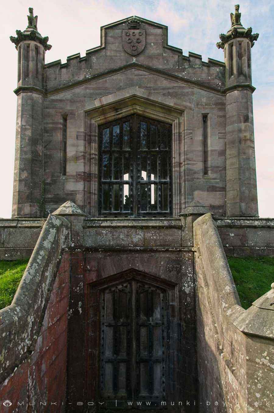
Dated AD 1857 over entrance, for William, second Earl of Lonsdale. Calciferous sandstone ashlar with polished Shap granite panels. Rectangular 3-bay chamber over basement. Front has steps down to double panelled doors in pointed arch. Above is a similar doorway with glazed panel doors, under Lowther arms. Battlemented shaped parapet and octagonal angle turrets, the caps with numerous carved heads and surmounted by griffins. Return walls have recesses with pointed granite panels under shaped parapet with 3 blank shields. Rear steps up to flagged walk around. Rear 4-light pointed-arched window. Inside is a marble seated figure of the 2nd Earl by E.B. Stephens 1863, nine years before his death.
Created: 1 November 2020 Edited: 29 November 2023
Lowther Mausoleum
Local History around Lowther Mausoleum
There are some historic monuments around including:
Settlement 100yds (90m) SE of Sceugh FarmRoman marching camp 450yds (410m) NE of BrovacumClifton Hall towerRound cairn on Askham Fell, 270m north of The Cop StoneRound cairn 515m south east of White Raise round cairn, Askham FellThe Old Kiln, Wetheriggs PotteryLittle Round Table hengeStone bridge, Cawdale BeckRound cairn 520m north east of The Cockpit, Askham FellRound cairn 680m ENE of DalefootRoman road and enclosures SE of FrenchfieldMoated site and annexe east of Setterahpark WoodWhite Raise round cairn, Askham FellCatterlen Hall tower houseFour funerary cairns and a surrounding cairnfield on Threepow RaiseRing cairn on Askham Fell including The Cop StoneRound cairn west of Riddingleys Top, Askham FellRing cairn on Askham Fell and four adjacent stonesSt Ninian's preconquest monastic site, site of nucleated medieval settlement, St Ninian's Church and churchyardRound cairn 50m north east of White Raise round cairn, Askham FellRomano-British settlement and regular aggregate field system north of Yanwath WoodStanding stone 180m NNE of SkirsgillLong cairn 330m east of MossthornSewborrans standing stone 400m south west of SewborwensRound cairn 490m south east of White Raise round cairn, Askham FellMoated site east of Newton ReignyRomano-British settlement at Cragside WoodThe Giant's Thumb - Anglian high cross in St Andrew's churchyard, PenrithRound cairn 280m south-east of The Cockpit stone circleBowl barrow 850m WSW of Yanwath Woodhouse FarmMayburgh hengeTowtop Kirk early Christian enclosureThe Cockpit stone circle and seven adjacent clearance cairns, Moor DivockThe Giant's Grave - Two Anglian cross-shafts and four hogback stones in St Andrew's churchyard, PenrithCastlesteads multivallate prehistoric defended enclosureRound cairn on Heughscar HillSlight univallate hillfort in Scarside PlantationRound cairn 580m north east of The Cockpit, Askham FellBridge over Heltondale Beck 250yds (230m) SSW of WidewathEamont BridgeBridge over Heltondale Beck 550ft (170m) S of WidewathTwo round cairns 415m and 420m NNE of The Cockpit, Moor DivockSkirsgill Romano-British enclosed stone hut circle settlement, Romano-British farmstead, and Romano-British regular aggregate field systemRing cairn on Knipescar Common south of Inscar PlantationBowl barrow 80m east of Scarside PlantationBrougham Roman fort (Brocavum) and civil settlement and Brougham CastleLong cairn 370m ESE of Mossthorn FarmBowl barrow 350m north east of The WreayAskham Fell stone alignmentRound barrow 150m east of Scarside PlantationThe Countess PillarStone circle 800m east of Wetheriggs PotteryRound cairn 490m ENE of Rough Hill TarnLong barrow on Trainford BrowKing Arthur's Round Table hengeStrickland's Pele Tower and Penrith CastleRing cairn on Knipescar CommonRound cairn 660m north east of The Cockpit, Askham FellMelkinthorpe medieval settlement, part of its associated open field system and the site of Melkinthorpe HallSite of Catterlen Old HallTwo standing stones and a round cairn south of CrooklandsRound cairn 475m south east of White Raise round cairn, Askham FellRound cairn 285m south east of White Raise round cairn, Askham FellSettlement 1/3 mile (540m) ENE of Brougham CastleLinear stone bank on Askham FellRing cairn east of Threepow RaiseRound cairn on Askham Fell, 335m north of the Cop Stone.


