A Stroll Around Askham
A Walk in Cumbria
Walk spec.
Difficulty: Easy
Basic length: 4.5Km (approx.)
Terrain:
- Mud tracks
- Tarmac
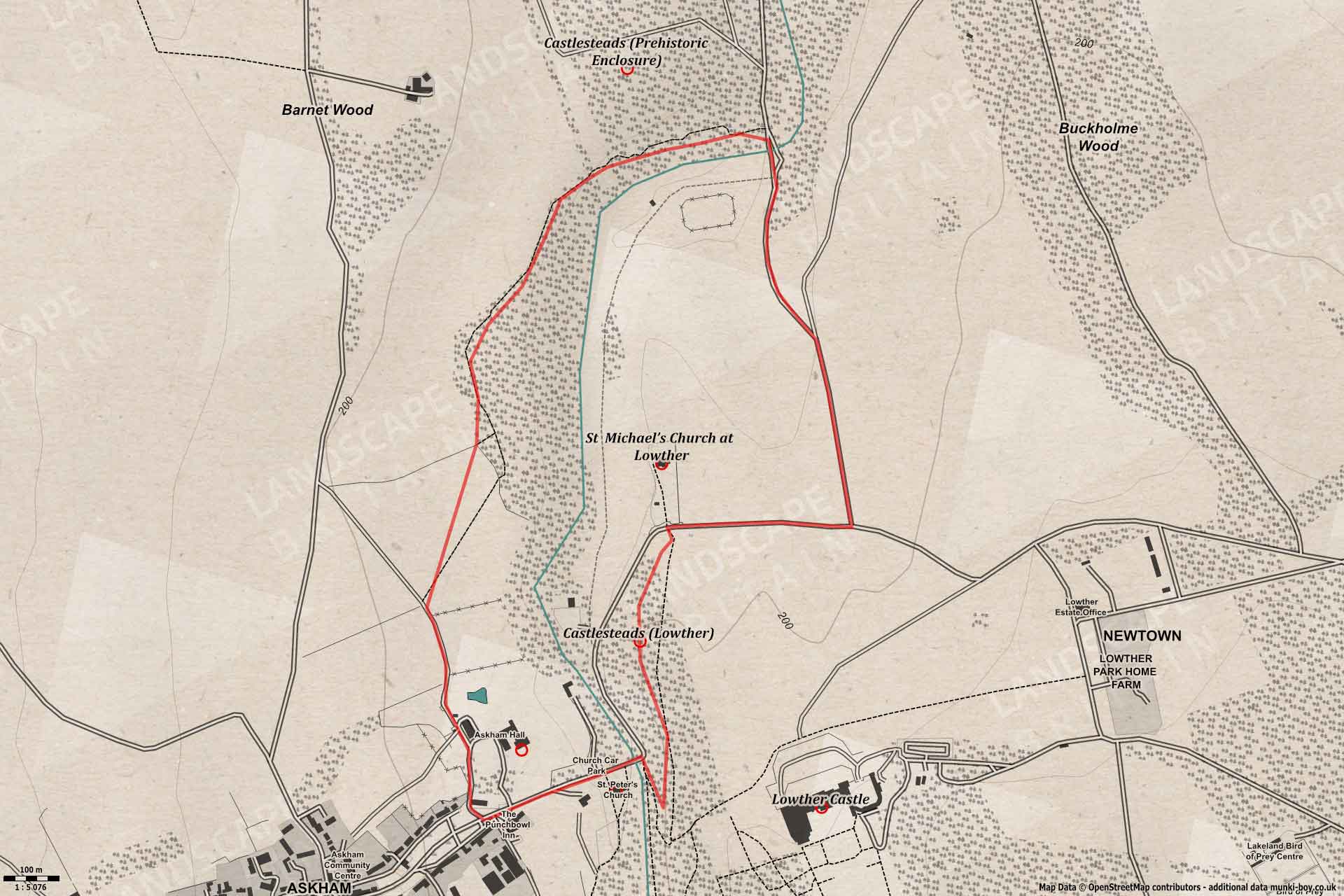
The village of Askham is pleasant enough, but a little investigation reveals a depth of history marked out on the surrounding landscape. This walk passes several monuments, ancient to modern-ish and takes in some lovely scenery and maybe some wildlife.
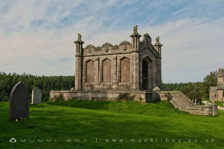
Lowther Family Mausoleum
1. Church of St Peter Askham
The walk starts from the tiny car park opposite St. Peter’s in Askham. St Peter’s is a small church that was built in 1832, while not interesting for its age, this church was built by the architect who designed Lowther Castle.
Setting off in an easterly direction towards the bridge over the River Lowther and once across turning right - away from the road and onto a woodland footpath which leads southwards parallel to the river ascending the bank, until turning sharply to the left and heading in almost the opposite direction. However, just in the area to the east, the old “back gate” of the Lowther gardens can be found (derelict a few years ago but probably in good shape after recent renovations).
Back on the track which soon levels out a bit and heads northwards.
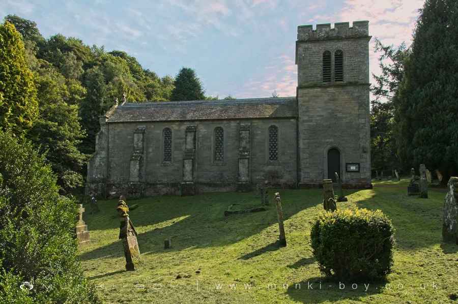
Church of St Peter Askham
2. Castellum de Lauudre
Just where the track bends to the right look out for an overgrown and tree-covered mound rising steeply on the right. This is the mound and foundation of a medieval castle or pele tower and is possibly the site of Castellum de Lauudre mentioned in 1174, the first known Lowther Castle in the area. Unless you’re very curious there’s not much to be gained by exploring the mound, especially in the summer when it is covered in stinging nettles. The top of the mound is a roughly-rectangular shape with a bank around the edges and is reckoned to have overlooked the river below. These trees aren’t very old and the hillside was perhaps bare less than a century or more ago.
Continuing by the track to the edge of the woods and area of fields and avenues of trees that were once part of the Lowther parkland. Somewhere under these landscaped fields lies the remains of the old medieval village, deserted centuries ago.
Bear northwards again to the close-by field gate opposite the interesting St. Michaels Church.
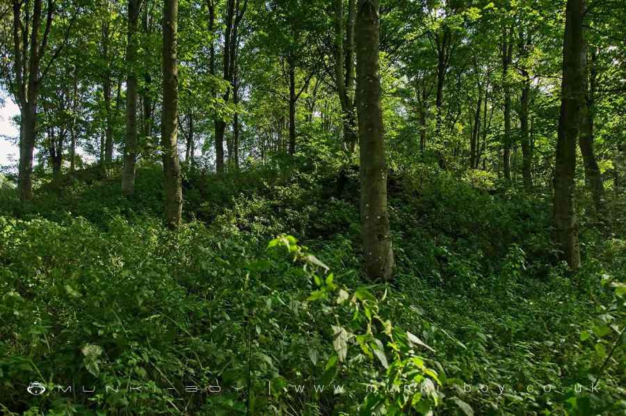
Castlesteads (Lowther)
3. St. Michael's Church and Mausoleum
A church has stood here since the 12th Century but the current building was rebuilt in the 17th Century and remodelled in the 19th. There are however a number of interesting monuments in the church and grounds. The churchyard is separate from the walk which continues on by, but do stop and take a look while you’re here.
Aside from the church the other prominent building is the mausoleum of the Lowther family and is curiously built on two levels. The top floor contains a large, marble statue of William, 2nd Earl of Lonsdale. I noticed beside william part of a broken female statue resting on the plinth. The mausoleum is dated 1857.
There are many old gravestones around the churchyard, some quite strange in design. But, the most ornate are within the church itself and include a life-size reclining knight, a huge brass plaque commemorating Henry Earl of Lonsdale and others. Also within the church after centuries in the churchyard are perhaps the most interesting artefacts - fragments of an ancient stone cross from the 12th Century and two Hogback gravestones that are even older, possibly 8th Century.
After thorough investigation, back the the church gate to turn left along the country lane.
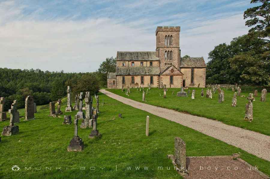
St Michael’s Church at Lowther
4. Down to the River
Leaving the church behind we follow the lane as far as the first-left turning down the tree lined avenue of Buckholme Drive. We are still with the old parkland of Lowther Park as we head northwards, towards a bend in the River Lowther where a slightly more modern, metal bridge crosses the river beside the older, stone-built Low Gardens Bridge. There is a nice, shallow spot beside the river here.
After the bridge we take the forest track turning left and following beside the river on our left, but straight-on is a farm track that after a good half-kilometre cuts through the edge of the old prehistoric ringfort but it is quite overgrown and not dissimilar to the earlier Castlesteads, except this one is round, far older, and has more banks and ditches. It’s an optional part of the walk for the keenest ancient site baggers. There is an overgrown path through the trees directly north/south from the main track - anyway we’ll see you back here if you take the detour.
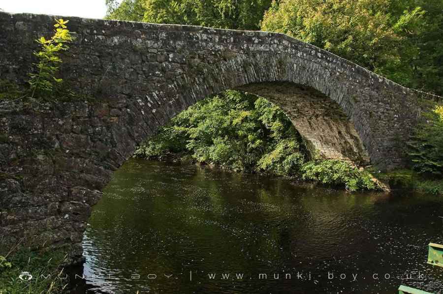
Low Gardens Bridge
5. Castlesteads Multivallate Defended Prehistoric Enclosure - optional
Terribly overgrown in the summer but terribly interesting this relatively rare type of mini-fort dates to around 600 BCE and represents a small community or farmstead, defended by a wooden palisade and surrounded by roughly circular banks and ditches. Probably with roundhouses within. I don’t think many people would have lived here at one time so the defences must have been a lot of work - it was certainly a dangerous time. These defended enclosures are said to have been in use until around the start of the Roman occupation.
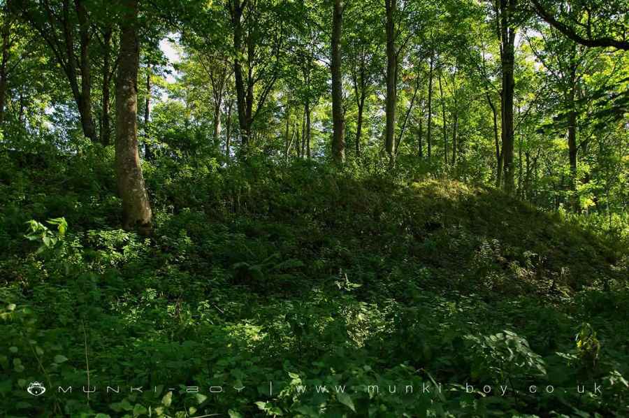
Castlesteads (Prehistoric Enclosure)
6. Askham Hall
Back at the main forest track we head westwards in a gentle arc bearing southwards through the woodland until a public footpath leaves the trees and crosses a field to reach the road not far from Askham Hall which gradually becomes visible on our left. The road eventually reaches a crossroads and then a left-turn just further on, which we should take, although the former leads a cul-de-sac but either will do on foot.
This stretch of road heading eastwards leads directly back to the Church of St. Peter from where we set off.
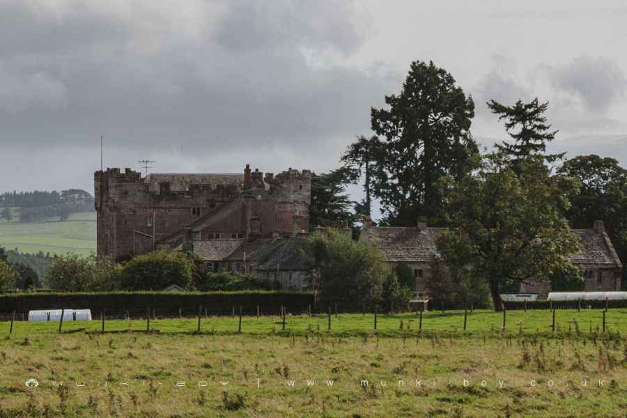
Askham Hall
Lowther Family Mausoleum
These walks are described for educational purposes only and we make no recommendation that you follow them, do so at your own risk. We accept no liability for your safety or for the reliability of the walk, map, description or anything else.
Mist, Mines and Ruins


Own label and private label building products
We produce, brand and supply for some of the biggest names in the industry. Read more...