Askham Hall by munki-boy
Askham Hall
Askham Hall is in The Lake District National Park in England.
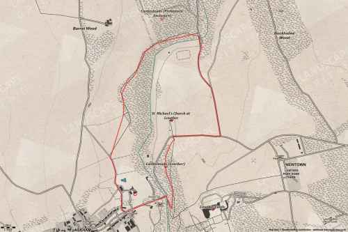
Askham Hall is situated on the eastern edge of the village of Askham overlooking the River Eamont, which lies some 200m to the east of the Hall, on land which slopes down to the south and east. The setting is rural and agricultural. The boundary of the c 3ha site is formed by a track between Askham and Broadgate on the west side, walls on the north and east sides, and a wall dividing the site from the by-road between Askham and Lowther on the south side.
The main entrance is on the south side of the site where a gateway with stone gate piers (late C17/early C18, listed grade II) leads to a drive which runs north and north-east to the Hall. A second drive leads to the north side of the Hall from the track to Broadgate.
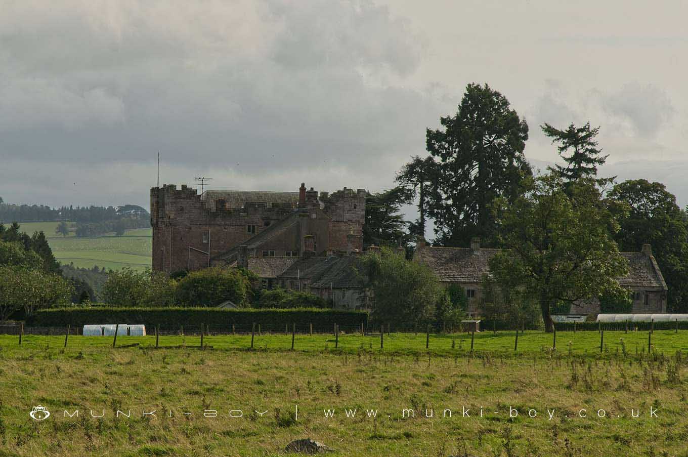
Askham Hall (listed grade I) originated as a pele tower, probably in the C14. It has three irregular wings around a rectangular courtyard. The tower forms the south front and was remodelled 1685-90, although medieval tunnel vaulting survives at ground floor level. The north wing retains some medieval work and the remainder of the building is of C16 and C17 date with later alterations and additions.
The gardens are on the south, west and east sides of the Hall. Immediately south of the Hall a sloping lawn is divided by a central path and there are signs of terracing, probably on the line of that shown on the 1859 OS map c 20m south of the Hall. South of this, and c 50m south of the Hall, there are two formal terraces (walls and steps listed grade II). The first terrace has an ashlar retaining wall with a cornice and a central gate which leads to steps down to the second terrace. This is also supported by a retaining wall and has central steps leading down to a lawn below. The terraces are c 22m long and are possibly of late C17 or C18 date. In the centre of the lawn below the terraces there is a mid C20 swimming pool.
On the north-east side of the Hall there is a rectangular formal garden with geometrical beds, enclosed on the north and south sides by yew hedges.
On the west side of the Hall there is a c 1ha area of woodland, with a central clearing. The large-scale OS map surveyed 1857-60 shows this area divided from the terraces by a boundary, possibly a fence or wall. An avenue is shown running north alongside the terraces on the east side of this division and the area now covered by trees is open land, with a possible vestigial avenue running from east to west across the area.
The gardens are shown extending eastwards down to the river on Greenwood?s county map of 1824. A building is shown south of the Hall, fronting the road, on Jeffreys’ county map of 1770, indicating a post 1770 expansion of the grounds down to the roadside.
The manor of Askham was acquired in 1280 by Sir Thomas de Helbeck, and remained in the de Helbeck family until the early C14 when it passed by marriage to the Swynburn family. An inquisition of 1326 refers to a dwelling on the site being partially burnt by the Scots. Edmund de Sandford and his wife Idonea, co-heiress of Sir Thomas English, came into possession of Askham in 1375, and it remained in the family for c 350 years. In 1680 it was sold to the Lowther family. In 1828 the Hall was in use as a rectory and is so described on the 1st edition OS map surveyed 1859. Following the abandonment of nearby Lowther Castle in the mid C20, it became the country seat of Lord Lonsdale and remains in use (1997) as a private residence.
Created: 30 October 2020 Edited: 29 November 2023
Askham Hall Information
Askham Hall Address
Askham Hall, Askham, Penrith
CA10 2PF
Website: http://www.askhamhall.co.uk/
Get directionsWalks in Askham Hall
Local History around Askham Hall
There are some historic monuments around including:
Bowl barrow 850m WSW of Yanwath Woodhouse FarmRound cairn 285m south east of White Raise round cairn, Askham FellRing cairn east of Threepow RaiseRound cairn 490m ENE of Rough Hill TarnRound cairn 520m north east of The Cockpit, Askham FellThe Cockpit stone circle and seven adjacent clearance cairns, Moor DivockThe Giant's Thumb - Anglian high cross in St Andrew's churchyard, PenrithRound cairn on Burn BanksStanding stone 180m NNE of SkirsgillRound cairn 660m north east of The Cockpit, Askham FellClifton Hall towerBowl barrow 350m north east of The WreayRing cairn on Knipescar CommonThe Countess PillarStone bridge, Cawdale BeckSettlement 100yds (90m) SE of Sceugh FarmLinear stone bank on Askham FellRound cairn west of Riddingleys Top, Askham FellRoman road and enclosures SE of FrenchfieldStrickland's Pele Tower and Penrith CastleFour funerary cairns and a surrounding cairnfield on Threepow RaiseSlight univallate hillfort in Scarside PlantationLong barrow on Trainford BrowRound cairn 50m north east of White Raise round cairn, Askham FellSewborrans standing stone 400m south west of SewborwensRound cairn west of enclosure on Four Stones HillAskham Fell stone alignmentSettlement 1/3 mile (540m) ENE of Brougham CastleRing cairn on Askham Fell and four adjacent stonesRound cairn 580m north east of The Cockpit, Askham FellRound cairn on Heughscar HillLittle Round Table hengeBridge over Heltondale Beck 550ft (170m) S of WidewathThe Giant's Grave - Two Anglian cross-shafts and four hogback stones in St Andrew's churchyard, PenrithRound cairn 490m south east of White Raise round cairn, Askham FellKing Arthur's Round Table hengeRound barrow 150m east of Scarside PlantationTwo round cairns 415m and 420m NNE of The Cockpit, Moor DivockMayburgh hengeLong cairn 370m ESE of Mossthorn FarmRound cairn north of Four Stones HillSkirsgill Romano-British enclosed stone hut circle settlement, Romano-British farmstead, and Romano-British regular aggregate field systemMelkinthorpe medieval settlement, part of its associated open field system and the site of Melkinthorpe HallRound cairn 475m south east of White Raise round cairn, Askham FellBridge over Heltondale Beck 250yds (230m) SSW of WidewathWhite Raise round cairn, Askham FellRound cairn 515m south east of White Raise round cairn, Askham FellCastlesteads multivallate prehistoric defended enclosureMoated site east of Newton ReignyBrougham Roman fort (Brocavum) and civil settlement and Brougham CastleRomano-British settlement and regular aggregate field system north of Yanwath WoodLong cairn 330m east of MossthornRing cairn on Askham Fell including The Cop StoneTwo standing stones north-west of Four Stones HillRound cairn 680m ENE of DalefootThe Old Kiln, Wetheriggs PotteryEamont BridgeBowl barrow 80m east of Scarside PlantationRoman marching camp 450yds (410m) NE of BrovacumRomano-British settlement at Cragside WoodRound cairn on Askham Fell, 270m north of The Cop StoneTowtop Kirk early Christian enclosureRound cairn on Askham Fell, 335m north of the Cop StoneSt Ninian's preconquest monastic site, site of nucleated medieval settlement, St Ninian's Church and churchyardTwo standing stones and a round cairn south of CrooklandsRing cairn on Knipescar Common south of Inscar PlantationMoated site and annexe east of Setterahpark WoodRound cairn 280m south-east of The Cockpit stone circle.


