Lyndley Wood Reservoir by Auto Locksmith
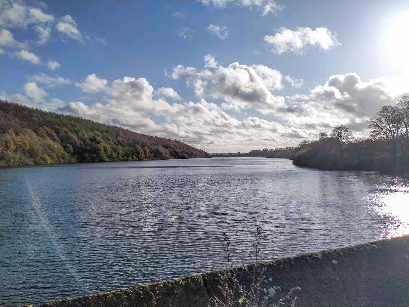
Lindley Wood Reservoir
Lindley Wood Reservoir is in Nidderdale AONB, a designated Area of Outstanding Natural Beauty.
Created: 19 November 2020 Edited: 29 November 2023
Lindley Wood Reservoir Details
Lindley Wood Reservoir is a small freshwater lake in North Yorkshire, situated at an altitude of around 93 meters and is shallow.
The shoreline of Lindley Wood Reservoir is approximately 4.918 Kilometers all the way round.
- Altitude: 93 m
- Shoreline: 4.918 Km
- Depth: Shallow
Lindley Wood Reservoir
Local History around Lindley Wood Reservoir
There are some historic monuments around including:
Otley BridgeAnti-aircraft gunsite 280m east of Carlton HallTwo carved rocks south of Snowden Beck in Ellers Wood, Dob Park, 570m south east of Carr FarmThree carved fragments of gritstone outcrop in enclosed pasture on Snowden Carr, 500m south west of Washburn FarmCup marked rock near gate in enclosed pasture on Snowden Carr, 460m south west of Washburn FarmCup, ring and groove marked rock south of track on Weston Moor 500m WNW of Weston Moor CottageCup and ring marked rock on ridge 520m south of triangulation pillar on Shooting House Hill, Askwith MoorCup and ring marked rock on Little Alms CliffRock with five or more cups south of track on Weston Moor 300m WNW of Weston Moor CottageRock with at least two cups and a groove east of the plantation on Weston Moor 450m north west of Weston Moor CottageCup marked rock 640m north east of Whin Hill Farm, Askwith MoorCarved rock on Pelstone Crag 530m west of Danefield HouseRock with one cup mark, 290m S of Crag House, Askwith MoorCup, ring and groove marked rock, 400m west of Carr FarmCairn 6m in diameter south of track east of plantation on Weston Moor 300m WNW of Weston Moor CottageCarved rock below Snowden Crags on Snowden Carr, 100m south of Crag HouseCairnfield, enclosures, boulder walling, hollow way and carved rocks towards edge of Snowden Carr centred at 370m south east of Crag HouseRoman period native settlement in Poolscar Wood, 350m south of Stubbings FarmCup and ring marked rock in Wharfemeadows Park, 280m west of Newall HallTwo cup marked rocks near track, 180m east of triangulation pillar on Shooting House Hill, Askwith MoorRock with one or two cup marks near derelict walling below outcrop in enclosed pasture on Snowden Carr, 350m west of Carr FarmRock with at least two cup marks south east of cairnfield on Snowden Carr, 720m SSE of Crag HouseRock with at least two cup marks on Hollin Tree Hill, 840m NNE of Whin Hill Farm, Askwith MoorCup, ring and groove marked rock in enclosed pasture on Snowden Carr, 500m south east of Crag HouseRock with cup marks, rings and grooves near derelict grouse butt, 440m SE of triangulation pillar on Shooting House Hill, Askwith MoorCarved rock near north east corner of the plantation on Weston Moor 550m north west of Weston Moor CottageCairn 7m in diameter north of track east of plantation on Weston Moor 450m WNW of Weston Moor CottageCairnfield and carved rocks on Snowden Carr 670m south west of Low Hall FarmCup marked rock in boulder walling between Southpiece Cottage and Bleach MillBank Slack (camp)Rock with one cup mark and two short grooves, south of Snowden Beck in Ellers Wood, Dob Park, 570m south east of Carr FarmMedieval royal hunting lodge known as John of Gaunt's Castle, immediately north west of Haverah Park TopRock with at least 30 cup marks and some grooves near north east end of ridge, south of Snowden Beck in Ellers Wood, Dob Park, 400m north of Low ParkRock with single cup mark near south east edge of gas pipeline, Snowden Carr, 430m SSE of Crag House, Askwith MoorCup marked rock 42m west of gate near Dob Park Bridge, adjacent to track on south bank of River WashburnRock with one large cup mark, 230m east of the triangulation pillar on Shooting House Hill, 610m SSW of Crag HouseRock with cup marks enclosed by grooves at north east end of ridge, south of Snowden Beck in Ellers Wood, Dob Park, 420m north of Low ParkRock with at least seven cup marks at edge of track on Stoop Hill, 890m SSE of triangulation point on Shooting House Hill, Askwith MoorCup and groove marked rock, 700m north east of Whin Hill Farm, Askwith MoorRoman period native settlement in Danefield Wood, 490m south west of Stubbings FarmRock with cup marks and grooves near boundary between Askwith Moor and Denton Moor, 600m east of DunkirkTwo carved rocks south of derelict grouse butt, 840m SSW of Crag HouseCup, ring and groove marked rock near gate in enclosed pasture on Snowden Carr, 350m south of Low Hill FarmRock with at least 33 cup marks, some enclosed by grooves, at top of slope between fence and Snowden Beck in Ellers Wood, Dob Park, 600m NE of Midge HallSmall cairnfield with carved rocks north of the plantation on Weston Moor centred 730m north west of Weston Moor CottageCup and ring marked rock known as the Knotties Stone on Otley Chevin, 270m north east of The Royalty public houseRock with large oval cup east of plantation on Weston Moor 830m WSW of Dob Park House FarmRock with one cup mark east of the plantation on Weston Moor 380m north west of Weston Moor CottageA 17th century park lodge known as Dobpark Lodge in Dob Park, near OtleyRock with at least eight cups south of track on Weston Moor 480m WNW of Weston Moor CottageCup and groove marked rock in boulder walling between Southpiece Cottage and Bleach Mill.Wildlife in and around Lindley Wood Reservoir
Lindley Wood Reservoir Birds
There are 165 species of birds recorded as found near Lindley Wood Reservoir.
| Arctic Tern (Sterna paradisaea) |
| Barn Owl (Tyto alba) |
| Bittern (Botaurus stellaris) |
| Black Tern (Chlidonias niger) |
| Black-Necked Grebe (Podiceps nigricollis) |
| Bar-Headed Goose (Anser indicus) |
| Barnacle Goose (Branta leucopsis) |
| Black Swan (Cygnus atratus) |
| Black-Headed Gull (Chroicocephalus ridibundus) |
| Blackbird (Turdus merula) |
Tap here for more wildlife found near Lindley Wood Reservoir lake


