


Otley
Otley
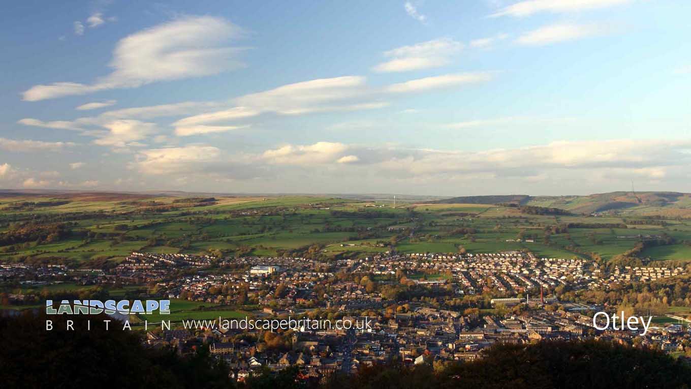
Otley is a town and civil parish in West Yorkshire, England. Historically part of the West Riding of Yorkshire, it lies approximately 12 miles to the north west of Leeds and 11 miles south east of Bradford.
Otley is twinned with Rothau, a city near Karlsruhe in Germany and has been since 1964. The River Wharfe runs past Otleys town centre. The name Otley was formed from Old English word ‘ot’ which means river source combined with ley for meadow thus ot meadow by the river. Otley grew up as a settlement along the top road or route out of Otley towards Ilkley and Burley in Wharfedale at the intersection with routes through Lumb Lane and along the River Wharfe. In the late 1800s, the town was a centre for wool production.
Otley is also home to many of Yorkshire’s breweries such as Thomas Fawcett & Sons Ltd., Otley Brewing Company and Black Sheep Brewery. Although not in Otley, The Tetley’s Brewery is very close by, in Hunslet, Leeds.
Created: 19 November 2020 Edited: 29 November 2023
Otley
Shopping in Otley
Waitrose supermarket and shopper's parking Otley, Leeds
Waitrose supermarket and shopper's parking retail park
The Parade Otley, Leeds
The Parade retail park
Asda Ritsons Yard, Cross Green
Asda supermarket
Waitrose 60, Westgate
Waitrose supermarket
Sainsbury's 11, Bondgate
Sainsbury's supermarket
Local History around Otley
There are some historic monuments around including:
Rock with cup marks and grooves near boundary between Askwith Moor and Denton Moor, 600m east of DunkirkAnti-aircraft gunsite 280m east of Carlton HallCup and ring marked rock on ridge 520m south of triangulation pillar on Shooting House Hill, Askwith MoorRock with one cup mark, 290m S of Crag House, Askwith MoorCup and ring marked rock 40m south east of Hillcourt, RawdonRock with one cup mark near boundary between Askwith Moor and Denton Moor, 590m ESE of DunkirkRock with at least 30 cup marks and some grooves near north east end of ridge, south of Snowden Beck in Ellers Wood, Dob Park, 400m north of Low ParkRock with at least eight cups south of track on Weston Moor 480m WNW of Weston Moor CottageCup and ring marked rock at Hoyle Court Drive, CharlestownCup and groove marked rock east of New Close Quarry, 300m south west of Whitbeck ManorRoman period native settlement in Poolscar Wood, 350m south of Stubbings FarmRock with large oval cup east of plantation on Weston Moor 830m WSW of Dob Park House FarmCup marked rock 640m north east of Whin Hill Farm, Askwith MoorCup and ring marked rock known as the Knotties Stone on Otley Chevin, 270m north east of The Royalty public houseCup and grooved marked rock in tree line between New Close Quarry and Poppling Well Beck, 280m south west of Whitbeck ManorSmall cairnfield with carved rocks north of the plantation on Weston Moor centred 730m north west of Weston Moor CottageRock with one cup mark east of the plantation on Weston Moor 380m north west of Weston Moor CottageOtley BridgeCairnfield and carved rocks on Snowden Carr 670m south west of Low Hall FarmCup and groove marked rock, 700m north east of Whin Hill Farm, Askwith MoorCairnfield, enclosures, boulder walling, hollow way and carved rocks towards edge of Snowden Carr centred at 370m south east of Crag HouseCarved rock in Hawksworth SpringTwo cup marked rocks near track, 180m east of triangulation pillar on Shooting House Hill, Askwith MoorRock with at least two cup marks south east of cairnfield on Snowden Carr, 720m SSE of Crag HouseCarved rock below Snowden Crags on Snowden Carr, 100m south of Crag HouseCairn 7m in diameter north of track east of plantation on Weston Moor 450m WNW of Weston Moor CottagePrehistoric enclosure, carved rocks and orthostat wall, Buck Wood, 195m west of football groundCup, ring and groove marked rock, 400m west of Carr FarmCup, ring and groove marked rock near gate in enclosed pasture on Snowden Carr, 350m south of Low Hill FarmCup, ring and groove marked rock south of track on Weston Moor 500m WNW of Weston Moor CottageRock with one or two cup marks near derelict walling below outcrop in enclosed pasture on Snowden Carr, 350m west of Carr FarmA 17th century park lodge known as Dobpark Lodge in Dob Park, near OtleyCarved rock near north east corner of the plantation on Weston Moor 550m north west of Weston Moor CottageRock with single cup mark near south east edge of gas pipeline, Snowden Carr, 430m SSE of Crag House, Askwith MoorCup and ring marked rock in Wharfemeadows Park, 280m west of Newall HallCup marked rock 42m west of gate near Dob Park Bridge, adjacent to track on south bank of River WashburnRock with one large cup mark, 230m east of the triangulation pillar on Shooting House Hill, 610m SSW of Crag HouseRock with cup marks enclosed by grooves at north east end of ridge, south of Snowden Beck in Ellers Wood, Dob Park, 420m north of Low ParkRock with one cup mark and two short grooves, south of Snowden Beck in Ellers Wood, Dob Park, 570m south east of Carr FarmRoman period native settlement in Danefield Wood, 490m south west of Stubbings FarmCup, ring and groove marked rock 15m from south wall of Gab Wood 300m east of Moseley Farm, CookridgeTwo carved rocks south of derelict grouse butt, 840m SSW of Crag HouseCarved rock on Pelstone Crag 530m west of Danefield HouseRock with cup marks, rings and grooves near derelict grouse butt, 440m SE of triangulation pillar on Shooting House Hill, Askwith MoorRock with at least two cups and a groove east of the plantation on Weston Moor 450m north west of Weston Moor CottageCup, ring and groove marked rock in enclosed pasture on Snowden Carr, 500m south east of Crag HouseCup marked rock near gate in enclosed pasture on Snowden Carr, 460m south west of Washburn FarmRock with at least 33 cup marks, some enclosed by grooves, at top of slope between fence and Snowden Beck in Ellers Wood, Dob Park, 600m NE of Midge HallCup and ring marked rock on Little Alms CliffCup marked rock in boulder walling between Southpiece Cottage and Bleach MillRock with five or more cups south of track on Weston Moor 300m WNW of Weston Moor CottageCup and groove marked rock in boulder walling between Southpiece Cottage and Bleach MillRock with at least seven cup marks at edge of track on Stoop Hill, 890m SSE of triangulation point on Shooting House Hill, Askwith MoorRock with at least two cup marks on Hollin Tree Hill, 840m NNE of Whin Hill Farm, Askwith MoorThree carved fragments of gritstone outcrop in enclosed pasture on Snowden Carr, 500m south west of Washburn FarmCairn 6m in diameter south of track east of plantation on Weston Moor 300m WNW of Weston Moor CottageCup, ring and groove marked rock 2m south of north wall of Gab Wood 330m E of Moseley Farm, CookridgeTwo carved rocks south of Snowden Beck in Ellers Wood, Dob Park, 570m south east of Carr Farm.Wildlife in and Around Otley
Mammals found in Otley
There have been 31 species of mammals recorded in the otley area.
| (Nyctalus/Eptesicus agg.) |
| 55 Khz Pipistrelle (Pipistrellus pygmaeus) |
| Badger (Meles meles) |
| Brown Hare (Lepus europaeus) |
| Brown Rat (Rattus norvegicus) |
| 45 Khz Pipistrelle (Pipistrellus pipistrellus) |
| American Mink (Neovison vison) |
| Brandt's Bat (Myotis brandtii) |
| Brown Long-Eared Bat (Plecotus auritus) |
| Common Shrew (Sorex araneus) |
Tap here for more mammals found in and around Otley
Birds found in Otley
There have been 50 species of birds recorded in the otley area.
| Bar-Headed Goose (Anser indicus) |
| Bittern (Botaurus stellaris) |
| Canada Goose (Branta canadensis) |
| Chukar Partridge (Alectoris chukar) |
| Common Swift (Apus apus) |
| Barnacle Goose (Branta leucopsis) |
| Buzzard (Buteo buteo) |
| Chestnut Teal (Anas castanea) |
| Common Sandpiper (Actitis hypoleucos) |
| Dunlin (Calidris alpina) |
Tap here for more birds found in and around Otley
Fish found in Otley
There have been 22 species of fish recorded in the otley area.
| Atlantic Salmon (Salmo salar) |
| Bream (Abramis brama) |
| Brown/Sea Trout (Salmo trutta) |
| Carp (Cyprinus carpio) |
| Dace (Leuciscus leuciscus) |
| Barbel (Barbus barbus) |
| Brown Trout (Salmo trutta subsp. fario) |
| Bullhead (Cottus gobio) |
| Chub (Squalius cephalus) |
| Eel (Anguilla anguilla) |


