Scone
Scone is a Town in the county of Perth and Kinross.
Scone postcode: PH2 6SA
There are great places to visit near Scone including some great rivers and streams, towns, lakes, historic buildings, ancient sites and waterfalls.
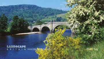
Don't miss River Tay's rivers and streams if visiting the area around Scone.
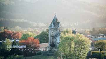
Don't miss Pitlochry, Dunkeld, and Aberfeldy's towns if visiting the area around Scone.
Don't miss Loch Faskally, and Loch Kennard's lakes if visiting the area around Scone.
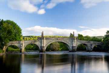
There are a several good historic buildings in the area around Scone like Wade's Bridge.
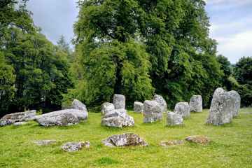
Don't miss Croftmoraig Stone Circle's ancient sites if visiting the area around Scone.
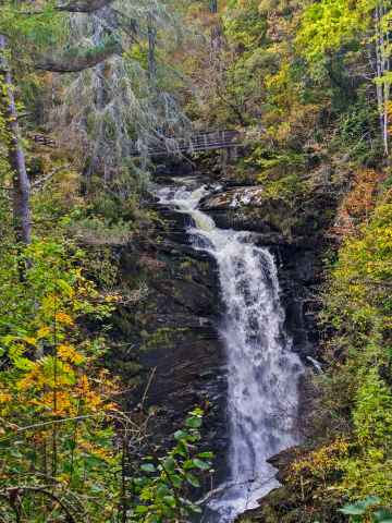
Places near Scone feature a number of interesting waterfalls including Falls of Moness.
Scone History
There are some historic monuments around Scone:
- Moncreiffe House, chapel Ecclesiastical: chapel SM9601
- Wellfield, enclosure 220m SSE of Prehistoric domestic and defensive: enclosure (domestic or defensive) SM9451
- Bonhard Park, unenclosed settlement SE of Prehistoric domestic and defensive: settlement SM6708
- Dow Hill, fort Prehistoric domestic and defensive: fort (includes hill and promontory fort) SM6718
- Castle Law,fort,Abernethy Prehistoric domestic and defensive: fort (includes hill and promontory fort) SM2477
- Elcho Castle Secular: castle SM90140
- Grassy Walls, Roman camp and prehistoric settlement, Sheriffton Prehistoric domestic and defensive: settlement; Roman: camp SM4072
- Wester Bonhard, unenclosed settlement 300m NNW of Prehistoric domestic and defensive: settlement SM6710
- Cramflat,standing stone E of Prehistoric ritual and funerary: standing stone SM1527
- Tofthill, enclosed settlement 300m NNW of Prehistoric domestic and defensive: settlement SM7237
- Kinnoull Church, remains of church and churchyard, Perth Ecclesiastical: burial ground, cemetery, graveyard SM6627
- Mill of Bonhard, unenclosed settlement and standing stone 200m S of Prehistoric domestic and defensive: settlement; Prehistoric ritual and funerary: standing stone SM6711
- St Madoes standing stones 200m WNW of Pitfour Castle Prehistoric ritual and funerary: standing stone SM1578
- Loanhead, standing stones 450m NE of Prehistoric ritual and funerary: standing stone SM7298
- Campsie Linn, grange site Ecclesiastical: grange/farm - secular buildings associated; Secular: manor house SM11143
- Bridge of Earn, Old Bridge of Earn Industrial: road or trackway SM9468
- Blairhall, barrow cemetery and cursus S of Prehistoric ritual and funerary: cursus/bank barrow SM6932
- Damside, fort 780m SW of Prehistoric domestic and defensive: fort (includes hill and promontory fort) SM7163
- Roman watch tower and unenclosed settlement, 310m NW of Strathview Cottage SM7182
- Settlement, 130m NNE of Ballendrick House Prehistoric domestic and defensive: enclosure (domestic or defensive) SM9446
- Gallowhill,stone circle 130m NE of Prehistoric ritual and funerary: stone circle or ring SM5408
- Gellybanks, standing stones 620m ESE of Prehistoric ritual and funerary: standing stone SM1548
- Moredun Top, fort Prehistoric domestic and defensive: fort (includes hill and promontory fort) SM9440
- Damside, stone row 900m SW of Prehistoric ritual and funerary: stone rows SM7297
- Law of Dumbuils, fort Prehistoric domestic and defensive: fort (includes hill and promontory fort) SM9439
- Cambusmichael, enclosure & souterrain 100m N of Prehistoric domestic and defensive: enclosure (domestic or defensive) SM7180
- Rhynd,old parish church 250m SW of Easter Rhynd Ecclesiastical: church SM5452
- Gold Castle, enclosure 200m SW of Donald's Bank Prehistoric domestic and defensive: enclosure (domestic or defensive) SM7572
- Moredun Hall, tower-house remains Secular: tower SM9464
- Bore Stone of Gask,cross slab,Moncreiffe House Crosses and carved stones: cross slab SM1620
- Over Benchil, standing stone 100m WSW of Prehistoric ritual and funerary: standing stone SM1574
- West Dron Cottages, cup-marked stone 800m SSW of Prehistoric ritual and funerary: cupmarks or cup-and-ring marks and similar rock art SM9444
- Blackfaulds, stone circle 450m WSW of Prehistoric ritual and funerary: stone circle or ring SM7295
- Berryhill, mortuary enclosures and pit-alignment 150m N of Prehistoric ritual and funerary: enclosure (ritual or funerary) SM7184
- Barrow and pit alignment, 205m NE and 100m NNW of Westways Prehistoric domestic and defensive: pit alignment; Prehistoric ritual and funerary: barrow SM7249
- Inchyra Farm, unenclosed settlement 500m NE of Prehistoric domestic and defensive: settlement SM7236
- Brownies Knowe, stone circle & cup-marked stone 400m WNW of Rosemount Prehistoric ritual and funerary: stone circle or ring SM7304
- Broombarns, settlement 300m S of Prehistoric domestic and defensive: enclosure (domestic or defensive) SM8771
- Castle Law,fort Prehistoric domestic and defensive: fort (includes hill and promontory fort) SM661
- Blindwells, stone circle 380m ENE of Prehistoric ritual and funerary: stone circle or ring SM7299
- Balholmie Cottage, unenclosed settlement 150m N of Prehistoric domestic and defensive: settlement SM7028
- Inchbervis Castle Secular: castle SM3763
- Balhomie, cup-marked stone 95m N of Prehistoric ritual and funerary: cupmarks or cup-and-ring marks and similar rock art SM7326
- Cambusmichael, palisaded enclosure 50m NW of Prehistoric domestic and defensive: palisaded enclosure SM7183
- Witch Knowe, barrow 130m SW of Inchyra House Prehistoric ritual and funerary: barrow SM7283
- King's Stone, standing stone 90m SE of Denmarkfield Farm Prehistoric ritual and funerary: standing stone SM1556
- Byres, ring-ditch and souterrain 330m NE of Prehistoric domestic and defensive: house SM7179
- Hill House, unenclosed settlement 100m NE of Prehistoric domestic and defensive: settlement SM7178
- Kirkton of Collace, cairn 420m S of Flowerdale Farm Prehistoric ritual and funerary: cairn (type uncertain) SM7188
- Newbigging Farm,cup and ring marked stone 225m WSW of Prehistoric ritual and funerary: cupmarks or cup-and-ring marks and similar rock art SM1509
- Law Hill, fort Prehistoric domestic and defensive: fort (includes hill and promontory fort) SM3089
- Deuchny Hill,fort Prehistoric domestic and defensive: fort (includes hill and promontory fort) SM6199
- Moncreiffe Hill, fort 800m NW of Moncreiffe House Prehistoric domestic and defensive: fort (includes hill and promontory fort) SM9438
- Barrow, 420m SE of Lochton House Prehistoric ritual and funerary: barrow SM6946
- Cambusmichael Church Ecclesiastical: church SM5641
- Ardgilzean Cottage, mound SW of Prehistoric ritual and funerary: mound (ritual or funerary) SM3402
- Kirkton of Collace, enclosure 380m ENE of Prehistoric domestic and defensive: enclosure (domestic or defensive) SM7266
- Perth, Cromwell's Citadel Secular: fort (non-prehistoric) SM8970
- Abernethy Round Tower and Pictish symbol stone Crosses and carved stones: symbol stone; Ecclesiastical: tower SM90005
- South Dumbuils, enclosure 500m SW of Prehistoric domestic and defensive: enclosure (domestic or defensive) SM9320
- New Scone,stone circle,Grey Stanes Prehistoric ritual and funerary: stone circle or ring SM1579
- Kinfauns Church Crosses and carved stones: cross slab; Ecclesiastical: church; Secular: mausoleum SM5642
- Huntingtower Castle Secular: castle SM90164
- Pole Hill, hut-circle 240m SE of triangulation point Prehistoric domestic and defensive: house SM6926
- Evelick,fort WSW of Prehistoric domestic and defensive: fort (includes hill and promontory fort) SM3095
- Bertha, Roman Fort Roman: fort SM2403
- Moated settlement 414m SW of Mains of Kinmonth SM9455
- Shianbank, stone circles and pillboxes 325m E of 20th Century Military and Related: Pillbox; Prehistoric ritual and funerary: stone circle or ring SM2314
- Sheriffton, barrow cemetery 200m NE of Prehistoric ritual and funerary: barrow SM6723
- Souterrains, 145m WNW and 115m WSW of Burnside Cottage Prehistoric domestic and defensive: souterrain, earth-house SM6717
- Pole Hill, cairn Prehistoric ritual and funerary: cairn (type uncertain) SM6928
- Lochton House, enclosure 350m ESE of Prehistoric domestic and defensive: enclosure (domestic or defensive) SM6722
- Arnbathie, fermtoun and enclosures NE of Secular: farmstead SM6709
- Law Hill,hut circles N of Prehistoric domestic and defensive: hut circle, roundhouse SM3279
- Shien Hill,cairn Prehistoric ritual and funerary: cairn (type uncertain) SM1581
- Balgarvie, unenclosed settlement 350m ESE of Prehistoric domestic and defensive: settlement SM6947
- Colen, stone circle 750m NNE of Prehistoric ritual and funerary: stone circle or ring SM7305
- Grange of Elcho, nunnery 180m ENE of Tay View Ecclesiastical: nunnery SM3232
- Carey, Roman temporary camp and enclosure, Abernethy Roman: camp SM9449
- Moot Hill royal assembly place and Scone Abbey, 100m NE of Scone Palace Ecclesiastical: abbey; Secular: meeting place, thingstead, moot hill SM13595
- Tammieteeth, cairn 500m W of Cairnbeddie Prehistoric ritual and funerary: cairn (type uncertain) SM7286