New Alyth
New Alyth is a Village in the county of Perth and Kinross.
New Alyth postcode: PH11 8NN
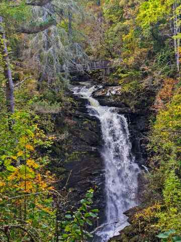
There are great places to visit near New Alyth including some great rivers and streams, towns, lakes, historic buildings, ancient sites and waterfalls.
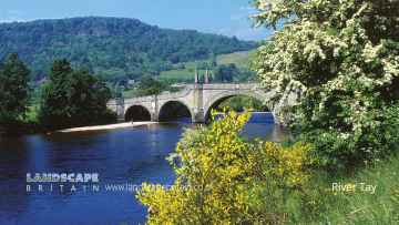
River Tay is a great place to visit close to New Alyth if you like rivers and streams.
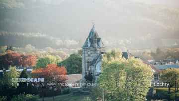
New Alyth has some unmissable towns nearby like Pitlochry, Dunkeld, and Aberfeldy.
There are a several good lakes in the New Alyth area like Loch Faskally, and Loch Kennard.
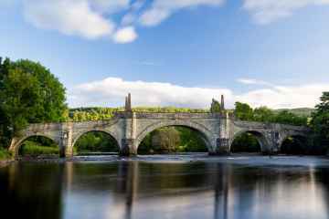
Places near New Alyth feature a number of interesting historic buildings including Wade's Bridge.
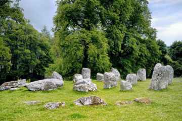
New Alyth is near some unmissable ancient sites like Croftmoraig Stone Circle,
The area around New Alyth's best waterfalls can be found at Falls of Moness.
New Alyth History
There are some historic monuments around New Alyth:
- Belmont Castle, standing stone 240m S of Prehistoric ritual and funerary: standing stone SM7296
- Lochlands, ring-ditches 250m NNW of Prehistoric domestic and defensive: house SM7257
- East Drimmie,stone circle 650m ENE of Prehistoric ritual and funerary: stone circle or ring SM1537
- Hallhole, ring-ditch 600m NNE of Prehistoric domestic and defensive: house SM7155
- Selvie,ring ditch and pit enclosure 500m NE of Prehistoric domestic and defensive: house SM6350
- St Moloc's Church,Alyth Ecclesiastical: church SM5583
- Grangemount, unenclosed settlement 330m S of Prehistoric domestic and defensive: settlement SM7255
- Bridgend of Ruthven,souterrain SW of Prehistoric domestic and defensive: souterrain, earth-house SM6334
- Auchtertyre,barrow 300m NNW of Prehistoric ritual and funerary: barrow SM6300
- Craighall, stone circle NE of Sawmill of Craighall Prehistoric ritual and funerary: stone circle or ring SM1525
- Pitcur Castle Secular: castle SM7332
- Kinpurnie Castle,cairn 400m WNW of Prehistoric ritual and funerary: cairn (type uncertain) SM6299
- Millhorn, ring-ditch 300m S of Prehistoric domestic and defensive: house SM7322
- Haughend, enclosure 500m W of Prehistoric domestic and defensive: enclosure (domestic or defensive) SM7263
- Grangemount, unenclosed settlement 350m SSW of Prehistoric domestic and defensive: settlement SM7699
- Strone Hill,settlements,fields,cairns,stone setting & hillside figures Prehistoric domestic and defensive: hut circle, roundhouse; Prehistoric ritual and funerary: ring cairn; Secular: settlement, including deserted, depopulated and townships SM4544
- Easter Rattray,standing stone 750m W of Prehistoric ritual and funerary: standing stone SM1538
- Macbeth's Stone, standing stone Prehistoric ritual and funerary: standing stone SM2408
- The Welton, palisaded enclosure and unenclosed settlement 295m SW of SM7177
- Pitcrocknie,standing stone 400m W of Prehistoric ritual and funerary: standing stone SM1575
- Redlatches,settlement and field system 1900m SSE of Prehistoric domestic and defensive: field or field system SM4640
- Unenclosed prehistoric settlement, 45m NE of Laystone House Prehistoric domestic and defensive: settlement SM6948
- Kettins Kirkyard,cross slab Crosses and carved stones: cross slab SM154
- Auchrannie,enclosure 550m NE of Prehistoric domestic and defensive: enclosure (domestic or defensive) SM6301
- Kirkhowe of Ruthven,cairn 580m NNW of Prehistoric ritual and funerary: cairn (type uncertain) SM7079
- Brankam Hill,houses,barrows,cairns and stone setting Prehistoric domestic and defensive: hut circle, roundhouse; Prehistoric ritual and funerary: barrow SM4419
- Dillavaird,palisaded homestead and souterrain 450m E of Prehistoric domestic and defensive: palisaded settlement SM6351
- Mudhall, unenclosed settlement E of Prehistoric domestic and defensive: settlement SM7321
- Brockhill Park, enclosure 400m SSW of Balhary Prehistoric domestic and defensive: enclosure (domestic or defensive) SM7260
- Wester Denhead, unenclosed settlement 120m E of Prehistoric domestic and defensive: settlement SM7328
- Cairn Plew, cairn 1350m NW of Wester Coul Prehistoric ritual and funerary: cairn (type uncertain) SM6842
- Barry Hill, fort Prehistoric domestic and defensive: fort (includes hill and promontory fort) SM1591
- Stormont Loch, crannog Prehistoric domestic and defensive: crannog SM7302
- Meigle,rectangular enclosures & posthole setting 120m SE of Chapelton Prehistoric domestic and defensive: enclosure (domestic or defensive) SM3708
- Coupar Grange, monastic grange NW of Ecclesiastical: grange/farm - secular buildings associated SM7327
- Leyston, settlement 500m NE of Prehistoric domestic and defensive: settlement SM7153
- The Welton, palisaded enclosure 600m W of and pit circle 700m W of Prehistoric domestic and defensive: palisaded enclosure SM7175
- Hallhole, barrow 600m ESE of Prehistoric ritual and funerary: barrow SM6949
- The Welton, fort, barrows & settlement S of Prehistoric domestic and defensive: fort (includes hill and promontory fort); Prehistoric ritual and funerary: barrow SM7173
- Milton of Rattray, cursus & enclosed settlement S of Prehistoric domestic and defensive: palisaded settlement; Prehistoric ritual and funerary: cursus/bank barrow SM7172
- East Myreriggs, enclosure 150m NE of Prehistoric domestic and defensive: enclosure (domestic or defensive) SM7330
- Torrax, cairn 1150m WNW of Prehistoric ritual and funerary: cairn (type uncertain) SM6844
- Glenballoch Cottage,standing stone E of Prehistoric ritual and funerary: standing stone SM1549
- Millhorn, unenclosed settlement 120m SE of Prehistoric domestic and defensive: house SM7323
- Lochlands, souterrain 340m NE of Prehistoric domestic and defensive: souterrain, earth-house SM7256
- Barry Hill, ring fort Prehistoric domestic and defensive: ring fort SM6549
- Bruceton Farm, symbol stone 410m SSE of Crosses and carved stones: symbol stone SM1619
- Hills of Bendochy,burial mound 700m SE of Prehistoric ritual and funerary: barrow SM4774
- Hallhole, enclosures and trackways NNE of Prehistoric domestic and defensive: settlement SM7023
- Knowehead, enclosure 300m N of Prehistoric domestic and defensive: enclosure (domestic or defensive) SM7318
- Coupar Angus,Abbey gatehouse Ecclesiastical: abbey SM1629
- Knowehead, standing stones 250m SSE of Prehistoric ritual and funerary: standing stone SM126
- Pitcur,souterrain NNE of Prehistoric domestic and defensive: souterrain, earth-house SM357
- The Welton, unenclosed settlement and souterrains 405m and 460m WSW of SM7176
- Lintrose House, unenclosed settlement 350m NE of Prehistoric domestic and defensive: settlement SM7250
- Coupar Angus Abbey,abbey precinct Ecclesiastical: abbey SM5772
- Millhorn, square barrow 450m SW of Prehistoric ritual and funerary: barrow SM7317
- Old Mains of Rattray, enclosed settlement and souterrains 500m NNW of Prehistoric domestic and defensive: palisaded settlement SM7210
- Cardean Roman Camp and pre-historic barrow, Wester Cardean Prehistoric ritual and funerary: barrow; Roman: camp SM4337
- High Keillor, symbol stone and cairn, 280m NW of Crosses and carved stones: symbol stone; Prehistoric ritual and funerary: cairn (type uncertain) SM146
- Mill of Peattie, cairn 500m SE of Prehistoric ritual and funerary: cairn (type uncertain) SM7244
- Ardmuir, pit-setting 300m NNW of Prehistoric domestic and defensive: posthole setting SM7245
- Shanzie Farm,standing stone 400m N of Prehistoric ritual and funerary: standing stone SM1580
- Jordanstone, unenclosed settlement SW of Prehistoric domestic and defensive: settlement SM7261
- Hallyards Cottages, moated settlement S of Secular: homestead moat SM7262
- Belliduff, cairn 380m NE of Belmont Castle Prehistoric ritual and funerary: cairn (type uncertain) SM7325
- Kilry, standing stone 100m NNE of Kilry School Prehistoric ritual and funerary: barrow SM124
- Redlatches,settlement and field system 1700m S of Prehistoric domestic and defensive: field or field system SM4673
- Milton of Ruthven,ring ditch 250m NE of Prehistoric domestic and defensive: house SM6298
- Wester Denhead, square barrow 200m W of Prehistoric ritual and funerary: barrow SM7329
- Torrax, cairn 650m WSW of Prehistoric ritual and funerary: cairn (type uncertain) SM8503
- Ryehill, ring-ditch 290m NW of Prehistoric domestic and defensive: house SM7324
- Easter Cammock,settlements,field systems and cairn 650m SW of Prehistoric domestic and defensive: field or field system; Prehistoric ritual and funerary: cairn (type uncertain); Secular: settlement, including deserted, depopulated and townships SM4586
- Pitmudie,stone setting 315m N of Prehistoric ritual and funerary: stone setting SM132
- Parkneuk,two stone circles 550m E of Prehistoric ritual and funerary: stone circle or ring SM1505
- Wester Coul, cairn 350m ESE of Prehistoric ritual and funerary: cairn (type uncertain) SM6846
- Ryehill, unenclosed settlement 400m NNW of Prehistoric domestic and defensive: settlement SM7316
- Craighead,settlement and field system 900m N of Prehistoric domestic and defensive: settlement SM5581
- Hallhole, square barrow and pit alignment 600m E of Prehistoric ritual and funerary: barrow SM6933
- Herald Hill, long barrow 700m NE of Hallhole Prehistoric ritual and funerary: long barrow SM7282
- Cardean, Roman fort 230m NW of Cardean Mill Roman: fort SM2306