Moulin
Moulin is a Village in the county of Perth and Kinross.
Moulin postcode: PH16 5EW
There are great places to visit near Moulin including some great rivers and streams, towns, lakes, historic buildings, ancient sites and waterfalls.
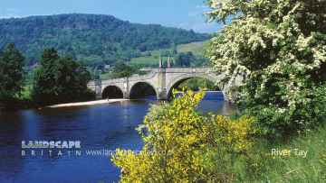
River Tay is one of Moulin's best, nearby rivers and streams to visit in Moulin.
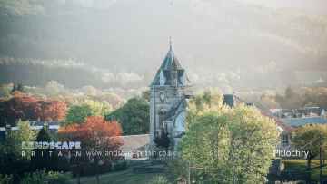
Pitlochry, Dunkeld, and Aberfeldy are some of Moulin best towns to visit near Moulin.
There are a number of lakes near Moulin including Loch Faskally, and Loch Kennard.
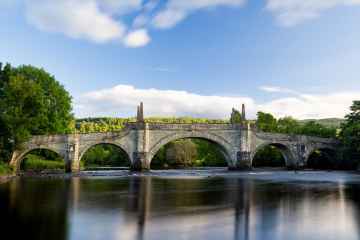
The area close to Moulin boasts some of the best historic buildings including Wade's Bridge.
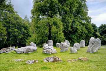
Places near Moulin feature a number of interesting ancient sites including Croftmoraig Stone Circle.
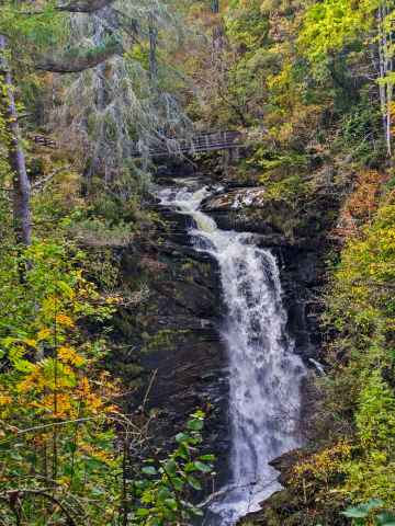
The area around Moulin's best waterfalls can be found at Falls of Moness.
Moulin History
There are some historic monuments around Moulin:
- Lude Church, 80m SSE of Kirkton of Lude Ecclesiastical: church SM9564
- Monzie,settlement and cultivation remains 600m SSE of Prehistoric domestic and defensive: settlement SM4497
- Old Faskally Farm, church 100m WSW of Ecclesiastical: church SM9566
- Logierait, fort, souterrains, roundhouses, pits and enclosure Prehistoric domestic and defensive: fort (includes hill and promontory fort) SM9525
- Findynate,homestead 450m SW of Secular: enclosure SM4850
- Kindallachan, cairn Prehistoric ritual and funerary: cairn (type uncertain) SM1554
- Castle Dow,fort Prehistoric domestic and defensive: fort (includes hill and promontory fort) SM4432
- Baldornie, deserted settlement 330m WNW of Ardtulichan Secular: settlement, including deserted, depopulated and townships SM9568
- Prince Charlie's Bridge, military bridge, Dalcapon Wood Industrial: road or trackway; Secular: bridge SM9581
- Balintuim,dun 310m NW of Prehistoric domestic and defensive: dun SM2860
- Milton of Edradour, enclosure 180m NE of Prehistoric domestic and defensive: enclosure (domestic or defensive) SM9530
- Reinakyllich, depopulated settlement Secular: settlement, including deserted, depopulated and townships SM9521
- Tynreich Cottages, stone circle 55m SSW of Prehistoric ritual and funerary: stone circle or ring SM1500
- Middleton,dun 240m WNW of Prehistoric domestic and defensive: dun SM2692
- Clunie Wood, An Dun fort Prehistoric domestic and defensive: fort (includes hill and promontory fort) SM9536
- Westhaugh of Tulliemet,cross slab 180m SE of Crosses and carved stones: cross slab SM1628
- Foirche,settlement,Dalshian Prehistoric domestic and defensive: settlement SM6296
- Green Gates stone circle, 320m ESE of Faskally Cottages Prehistoric ritual and funerary: stone circle or ring SM1545
- Tomnauld,hut circle 1600m NE of Prehistoric domestic and defensive: hut circle, roundhouse SM4494
- Upper Ballachandy,settlement and field system 1500m NE of Prehistoric domestic and defensive: field or field system SM4605
- Findynate Farm, standing stones 1200m NNW of Prehistoric ritual and funerary: standing stone SM9510
- Kincraigie, homestead 170m NNW of Prehistoric domestic and defensive: homestead SM9616
- Tomtayewen, dun Prehistoric domestic and defensive: dun SM2621
- Pitcastle,dun 180m SW of Prehistoric domestic and defensive: dun SM726
- Badyo,hut circles 1475m SW of Prehistoric domestic and defensive: hut circle, roundhouse SM4716
- Middleton of Derculich, chambered cairn 70m SE of Prehistoric ritual and funerary: chambered cairn SM2666
- Pitfourie, standing stone 230m ESE of Prehistoric ritual and funerary: standing stone SM1534
- Balnaguard Farm, standing stone 220m N of Prehistoric ritual and funerary: standing stone SM1504
- Lundin, stone circle and cup-marked stone 370m NNW of Prehistoric ritual and funerary: stone circle or ring SM1563
- Croft of Baledmund, hut circles & field system 800m to 1250m NNE of Prehistoric domestic and defensive: field or field system SM8713
- Tomnauld,settlements and field system 1850m NE of Prehistoric domestic and defensive: field or field system SM4493
- Monzie,settlements 400m SE of Prehistoric domestic and defensive: settlement; Secular: farmstead SM4496
- Kinnaird,hut circles 1400m NE of Prehistoric domestic and defensive: hut circle, roundhouse SM4819
- Stac an Eich, fort Prehistoric domestic and defensive: fort (includes hill and promontory fort) SM9527
- Druim nan Aigeach, deserted settlement Secular: settlement, including deserted, depopulated and townships SM9570
- Clachan More, two standing stones 100m WSW of Dowally Kirk Prehistoric ritual and funerary: standing stone SM1514
- Badyo,hut circles and farmstead 1900m SW of Prehistoric domestic and defensive: hut circle, roundhouse; Secular: farmstead SM4969
- Clachan an Diridh, stone circle 1700m SW of Netherton Prehistoric ritual and funerary: stone circle or ring SM1513
- Meall Uaine, round houses 940m, 1020m and 1040m NE of Loch Scoly Prehistoric domestic and defensive: hut circle, roundhouse SM5859
- Kinnaird,settlements & field systems 1500m NE of Prehistoric domestic and defensive: hut circle, roundhouse SM4828
- Balnaguard,settlements & field systems 1900m S of Prehistoric domestic and defensive: field or field system; Secular: settlement, including deserted, depopulated and townships SM5320
- Creag Eilid,settlements,field system and cairn 1000m ESE of Prehistoric domestic and defensive: field or field system; Prehistoric ritual and funerary: cairn (type uncertain); Secular: house SM5321
- Cnoc na Craoibhe, shieling huts 250m NNE of Secular: shieling SM9517
- Haugh of Grandtully, standing stone and barrows 490m WNW of Prehistoric ritual and funerary: standing stone SM1576
- Monzie,burial mound 300m NW of Prehistoric ritual and funerary: mound (ritual or funerary) SM4482
- Caisteal Dubh, castle 200m ESE of Balnadrum Farm Secular: castle SM1636
- Balnaguard Farm, roundhouse 440m NNE of Prehistoric domestic and defensive: hut circle, roundhouse SM9522
- Tulloch of Pitnacree, enclosure 150m NW of Prehistoric domestic and defensive: enclosure (domestic or defensive) SM9528
- Kinnaird,hut circle 1200m NW of Prehistoric domestic and defensive: hut circle, roundhouse SM4818
- Old Faskally Farm, hut circles, enclosure and field system 900m SE of Prehistoric domestic and defensive: hut circle, roundhouse SM9516
- Lower Drumchorrie,dun 260m WNW of Prehistoric domestic and defensive: dun SM2667
- Cairn 30m NW of Sunny Bank, Balnaguard Prehistoric ritual and funerary: cairn (type uncertain) SM2232
- Badyo,settlement & field system 1450m SW of Prehistoric domestic and defensive: hut circle, roundhouse SM4830
- Monzie,hut circles 700m SSE of Prehistoric domestic and defensive: hut circle, roundhouse SM4495
- Cuil-an-Daraich, enclosure 170m E of Prehistoric domestic and defensive: enclosure (domestic or defensive) SM9526
- Badyo,settlements & field system 550m W of Prehistoric domestic and defensive: field or field system; Secular: house SM4751
- Sithean,cairn Prehistoric ritual and funerary: cairn (type uncertain) SM2383
- Balenduin, cairn 80m SE of Prehistoric ritual and funerary: barrow SM4318
- Claverhouse's Stone, standing stone 200m S of House of Urrard Prehistoric ritual and funerary: standing stone SM1520
- Kindallachan, standing stone Prehistoric ritual and funerary: standing stone SM9618
- Dunvorist,dun 180m S of Prehistoric domestic and defensive: dun SM2664
- Haugh of Grandtully, fort 200m SSE of Prehistoric domestic and defensive: field or field system SM9533
- Logierait Churchyard,cross slab Crosses and carved stones: cross slab SM1624
- Dunfallandy Stone, cross slab Crosses and carved stones: cross slab SM90115
- Torvuick, deserted settlement 200m ENE of Clunie Dam Secular: settlement, including deserted, depopulated and townships SM9565
- Pitnacree,burial mound 350m NW of West Mains Prehistoric ritual and funerary: barrow SM6147
- Badyo,settlement & field system 2000m W of Prehistoric domestic and defensive: field or field system SM4715
- Tullypowrie Burn,chapel,cross slab,farmstead and mill Crosses and carved stones: cross-incised stone; Ecclesiastical: church; Industrial: farming, food production; Secular: farmstead SM5446
- Strathgarry Farm, standing stones 910m SW of Prehistoric ritual and funerary: standing stone SM9514
- Tom na Croiche,castle Secular: castle SM2638
- Druid, settlement and field system 700m NE of Prehistoric domestic and defensive: field or field system SM4449
- Cup and ring marked stone, dun and farmstead 70m SW of Brae of Cultullich Prehistoric domestic and defensive: dun; Prehistoric ritual and funerary: cupmarks or cup-and-ring marks and similar rock art; Secular: farmstead SM2669
- Lundin, dun 500m NNE of Prehistoric domestic and defensive: dun SM2665
- Loch Moraig, deserted settlements 700m NE of Secular: settlement, including deserted, depopulated and townships SM9573
- Little Shinagag, deserted settlement Secular: settlement, including deserted, depopulated and townships SM9571
- Dunfallandy,bell cairn Prehistoric ritual and funerary: bell cairn SM2259
- Meall Mor, deserted settlement 700m NE of Secular: settlement, including deserted, depopulated and townships SM9572
- Druid, settlement and cultivation remains 600m E of Prehistoric domestic and defensive: field or field system SM4471
- Knockbarrie,hut circles and field system 1900m ENE of Prehistoric domestic and defensive: field or field system SM4634
- Clach Glas, standing stone 130m WSW of Westhaugh of Tulliemet Prehistoric ritual and funerary: standing stone SM1515
- Cammoch, deserted settlement Secular: settlement, including deserted, depopulated and townships SM9569
- Mill-Lands of Dalcapon, enclosure 290m SSE of Prehistoric ritual and funerary: enclosure (ritual or funerary) SM9524
- Castle Dow,hut circles 1150m SSW of Prehistoric domestic and defensive: hut circle, roundhouse SM5910