Meikleour
Meikleour is a Village in the county of Perth and Kinross.
Meikleour postcode: PH2 6ER
There are great places to visit near Meikleour including some great rivers and streams, towns, lakes, historic buildings, ancient sites and waterfalls.
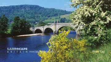
Places near Meikleour feature a number of interesting rivers and streams including River Tay.
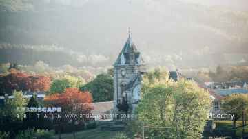
There are a several good towns in the Meikleour area like Pitlochry, Dunkeld, and Aberfeldy.
There are a number of lakes near Meikleour including Loch Faskally, and Loch Kennard.
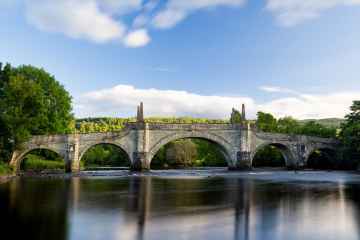
There are a number of historic buildings near to Meikleour including Wade's Bridge.
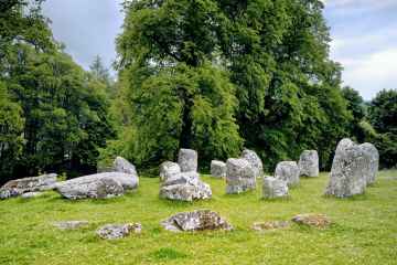
There are a number of ancient sites near to Meikleour including Croftmoraig Stone Circle.
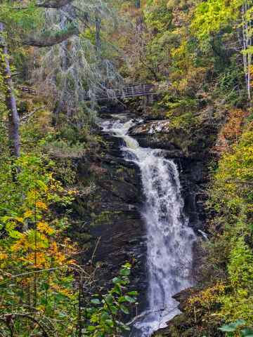
There are a number of waterfalls near to Meikleour including Falls of Moness.
Meikleour History
There are some historic monuments around Meikleour:
- Inchtuthil Farm,fort N of Prehistoric domestic and defensive: fort (includes hill and promontory fort) SM1596
- Whitemyre, hut-circle 550m ENE of Prehistoric domestic and defensive: hut circle, roundhouse SM7200
- Inchbervis Castle Secular: castle SM3763
- Balhomie, cup-marked stone 95m N of Prehistoric ritual and funerary: cupmarks or cup-and-ring marks and similar rock art SM7326
- Byres, ring-ditch and souterrain 330m NE of Prehistoric domestic and defensive: house SM7179
- Millhorn, square barrow 450m SW of Prehistoric ritual and funerary: barrow SM7317
- Hills of Bendochy,burial mound 700m SE of Prehistoric ritual and funerary: barrow SM4774
- Whiteloch, ring-ditch 130m S of Prehistoric domestic and defensive: house SM7164
- The Welton, palisaded enclosure and unenclosed settlement 295m SW of SM7177
- Hallhole, ring-ditch 600m NNE of Prehistoric domestic and defensive: house SM7155
- The Welton, unenclosed settlement and souterrains 405m and 460m WSW of SM7176
- East Myreriggs, enclosure 150m NE of Prehistoric domestic and defensive: enclosure (domestic or defensive) SM7330
- Old Mains of Rattray, enclosed settlement and souterrains 500m NNW of Prehistoric domestic and defensive: palisaded settlement SM7210
- Hallhole, barrow 600m ESE of Prehistoric ritual and funerary: barrow SM6949
- Damside, fort 780m SW of Prehistoric domestic and defensive: fort (includes hill and promontory fort) SM7163
- Cairn Muir, cairn 190m NW of Cairnmuir Prehistoric ritual and funerary: cairn (type uncertain) SM7287
- Mains of Gourdie, ring-ditch 120m SSW of Prehistoric domestic and defensive: hut circle, roundhouse SM6895
- Hallhole, square barrow and pit alignment 600m E of Prehistoric ritual and funerary: barrow SM6933
- Loanhead, standing stones 450m NE of Prehistoric ritual and funerary: standing stone SM7298
- Glendelvine House, barrow and standing stone 200m S of Prehistoric ritual and funerary: barrow SM7127
- Glasclune Castle Secular: castle SM5104
- Broadmyre, pit-enclosure 130m SSW of Prehistoric ritual and funerary: enclosure (ritual or funerary) SM7168
- The Welton, fort, barrows & settlement S of Prehistoric domestic and defensive: fort (includes hill and promontory fort); Prehistoric ritual and funerary: barrow SM7173
- Glenballoch Cottage,standing stone E of Prehistoric ritual and funerary: standing stone SM1549
- Unenclosed prehistoric settlement, 45m NE of Laystone House Prehistoric domestic and defensive: settlement SM6948
- Stormont Loch, crannog Prehistoric domestic and defensive: crannog SM7302
- Coin Hill, unenclosed settlement W of Hallhole Prehistoric domestic and defensive: settlement SM6952
- Craighall, stone circle NE of Sawmill of Craighall Prehistoric ritual and funerary: stone circle or ring SM1525
- Middle Gourdie, unenclosed settlement 400m SE of Prehistoric domestic and defensive: settlement SM6894
- Colen, stone circle 750m NNE of Prehistoric ritual and funerary: stone circle or ring SM7305
- Castle Hill, castle and site of church 70m NE of Clunie Church Secular: castle SM1638
- Leys of Marlee Farm,stone circle,Blairgowrie-Lethendy Road Prehistoric ritual and funerary: stone circle or ring SM1560
- Macbeth's Law,mound,Lawton House Prehistoric ritual and funerary: mound (ritual or funerary) SM3393
- Cambusmichael Church Ecclesiastical: church SM5641
- Loch of Clunie,crannog 450m NNE of Clunie Castle Prehistoric domestic and defensive: crannog SM5505
- Berryhill, mortuary enclosures and pit-alignment 150m N of Prehistoric ritual and funerary: enclosure (ritual or funerary) SM7184
- Fir Hillock, burial mound 750m E of Ardblair Castle Prehistoric ritual and funerary: barrow SM9612
- Knowehead, enclosure 300m N of Prehistoric domestic and defensive: enclosure (domestic or defensive) SM7318
- Dunsinane Hill, fort Prehistoric domestic and defensive: fort (includes hill and promontory fort) SM1595
- Kinclaven Castle Secular: castle SM1640
- Middleton Muir,settlements,field systems,cairns and deer dyke Prehistoric domestic and defensive: hut circle, roundhouse; Prehistoric ritual and funerary: ring cairn; Secular: linear earthwork, dyke SM5396
- Glendelvine, souterrain 90m NW of Lodge Cottages Prehistoric domestic and defensive: souterrain, earth-house SM7135
- East Drimmie,stone circle 650m ENE of Prehistoric ritual and funerary: stone circle or ring SM1537
- Blackfaulds, stone circle 450m WSW of Prehistoric ritual and funerary: stone circle or ring SM7295
- Newbigging Farm,cup and ring marked stone 225m WSW of Prehistoric ritual and funerary: cupmarks or cup-and-ring marks and similar rock art SM1509
- Roman watch tower and unenclosed settlement, 310m NW of Strathview Cottage SM7182
- Cargill,Roman fort Roman: fort SM4269
- Ardmuir, pit-setting 300m NNW of Prehistoric domestic and defensive: posthole setting SM7245
- Hill House, unenclosed settlement 100m NE of Prehistoric domestic and defensive: settlement SM7178
- Brownies Knowe, stone circle & cup-marked stone 400m WNW of Rosemount Prehistoric ritual and funerary: stone circle or ring SM7304
- Links, enclosure 320m E of Prehistoric domestic and defensive: enclosure (domestic or defensive) SM7042
- Balholmie Cottage, unenclosed settlement 150m N of Prehistoric domestic and defensive: settlement SM7028
- Lochlands, ring-ditches 250m NNW of Prehistoric domestic and defensive: house SM7257
- Leyston, settlement 500m NE of Prehistoric domestic and defensive: settlement SM7153
- Milton of Rattray, cursus & enclosed settlement S of Prehistoric domestic and defensive: palisaded settlement; Prehistoric ritual and funerary: cursus/bank barrow SM7172
- Millhole, unenclosed settlement 450m ESE of Prehistoric domestic and defensive: house SM7166
- Kirkton of Collace, cairn 420m S of Flowerdale Farm Prehistoric ritual and funerary: cairn (type uncertain) SM7188
- Lochlands, souterrain 340m NE of Prehistoric domestic and defensive: souterrain, earth-house SM7256
- Wester Drumatherty, unenclosed settlement 300m W of Prehistoric domestic and defensive: settlement SM7165
- Campsie Linn, grange site Ecclesiastical: grange/farm - secular buildings associated; Secular: manor house SM11143
- Bandirran, stone circle & standing stones 270m to 425m ENE of Prehistoric ritual and funerary: stone circle or ring SM7301
- Ardgilzean Cottage, mound SW of Prehistoric ritual and funerary: mound (ritual or funerary) SM3402
- Middle Gourdie, souterrain 380m SSW of Prehistoric domestic and defensive: souterrain, earth-house SM6896
- Ardblair Castle, earthwork 225m E of Secular: enclosure SM9642
- Myreside, ring-ditch & pit-alignment 440m S of Prehistoric domestic and defensive: house SM7190
- Inchtuthil, Roman fortress Roman: fort SM1606
- Leys of Marlee, ring-ditch 400m SSW of Prehistoric ritual and funerary: barrow SM7170
- Hallhole, enclosures and trackways NNE of Prehistoric domestic and defensive: settlement SM7023
- Kirkton of Collace, enclosure 380m ENE of Prehistoric domestic and defensive: enclosure (domestic or defensive) SM7266
- Steed Stalls,Roman camp Roman: camp SM3022
- Balcairn, cairn 350m W of Prehistoric ritual and funerary: cairn (type uncertain) SM7285
- Middle Gourdie, palisaded enclosure & unenclosed settlement 800m SW of Prehistoric domestic and defensive: palisaded enclosure SM7185
- Culthill, souterrains 100m ESE of Prehistoric domestic and defensive: souterrain, earth-house SM7129
- Glendelvine House, cairn 330m S of Prehistoric ritual and funerary: cairn (type uncertain) SM7284
- Damside, stone row 900m SW of Prehistoric ritual and funerary: stone rows SM7297
- Cambusmichael, palisaded enclosure 50m NW of Prehistoric domestic and defensive: palisaded enclosure SM7183
- Over Benchil, standing stone 100m WSW of Prehistoric ritual and funerary: standing stone SM1574
- Ring-ditch 448m S of Leys of Marlee Prehistoric ritual and funerary: barrow SM7171
- The Welton, palisaded enclosure 600m W of and pit circle 700m W of Prehistoric domestic and defensive: palisaded enclosure SM7175
- Cargill, Roman fortlet and ring-ditches 400m NE of Mains of Cargill Prehistoric domestic and defensive: enclosure (domestic or defensive); Roman: fortlet SM2833
- Burnbank, barrows, enclosures & unenclosed settlement SW of Prehistoric domestic and defensive: enclosure (domestic or defensive); Prehistoric ritual and funerary: barrow SM7189
- Meikleour, enclosures 500m NE of Prehistoric domestic and defensive: enclosure (domestic or defensive); Prehistoric ritual and funerary: enclosure (ritual or funerary) SM7027
- The Cleaven Dyke, cursus & bank barrow Prehistoric ritual and funerary: cursus/bank barrow SM1602
- Cambusmichael, enclosure & souterrain 100m N of Prehistoric domestic and defensive: enclosure (domestic or defensive) SM7180
- Gallowhill,stone circle 130m NE of Prehistoric ritual and funerary: stone circle or ring SM5408
- Nether Gothens, enclosure S of Prehistoric domestic and defensive: palisaded enclosure SM7162
- Stone circle, 52m southwest of Druid's Park House Prehistoric ritual and funerary: stone circle or ring SM1571
- Blackhillock, souterrain 50m W of Prehistoric domestic and defensive: souterrain, earth-house SM7132
- Clunie Castle Secular: castle SM5508
- Tammieteeth, cairn 500m W of Cairnbeddie Prehistoric ritual and funerary: cairn (type uncertain) SM7286
- Ardlin, unenclosed settlement 700m W of Prehistoric domestic and defensive: settlement SM7186
- Carsie Mains, pit-circle & mortuary enclosure 400m NNE of Prehistoric ritual and funerary: enclosure (ritual or funerary) SM7167
- Herald Hill, long barrow 700m NE of Hallhole Prehistoric ritual and funerary: long barrow SM7282
- Castle Hill,motte W of Mains of Cargill Secular: motte SM3198
- Upper Gothens, enclosure 350m ESE of Prehistoric domestic and defensive: palisaded enclosure SM7169
- Black Hill,Roman signal station Roman: signal station SM4233
- Easter Rattray,standing stone 750m W of Prehistoric ritual and funerary: standing stone SM1538
- Blindwells, stone circle 380m ENE of Prehistoric ritual and funerary: stone circle or ring SM7299
- Meikleour House, motte W of Secular: motte SM7293