Dunning
Dunning is a Village in the county of Perth and Kinross.
Dunning postcode: PH2 0RT
There are great places to visit near Dunning including some great rivers and streams, towns, lakes, historic buildings, ancient sites and waterfalls.
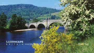
Dunning is near some unmissable rivers and streams like River Tay,
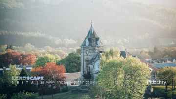
Pitlochry, Dunkeld, and Aberfeldy are some of Dunning best towns to visit near Dunning.
Lakes to visit near Dunning include Loch Faskally, and Loch Kennard.
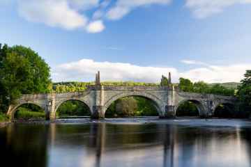
The area close to Dunning boasts some of the best historic buildings including Wade's Bridge.
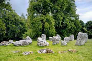
The area around Dunning's best ancient sites can be found at Croftmoraig Stone Circle.
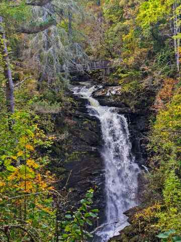
There are a number of waterfalls near to Dunning including Falls of Moness.
Dunning History
There are some historic monuments around Dunning:
- Masterfield. pit alignments 450m NNE of Prehistoric ritual and funerary: pit alignment (ritual or funerary) SM8768
- Castle Craig, fort SSW of Pairney Prehistoric domestic and defensive: fort (includes hill and promontory fort) SM4213
- St Serf's Church, Dunning Ecclesiastical: burial ground, cemetery, graveyard SM90321
- Mains of Huntingtower, henge, enclosures, pits and road WSW of Prehistoric domestic and defensive: enclosure (domestic or defensive); Prehistoric ritual and funerary: henge; Roman: road SM3630
- Loanleven, enclosure 300m SSW of Prehistoric ritual and funerary: enclosure (ritual or funerary) SM8755
- Inverdunning House, henge 140m S of Prehistoric ritual and funerary: henge SM8922
- Jackschairs Wood,fort 300m ESE of Netherholm Prehistoric domestic and defensive: fort (includes hill and promontory fort) SM1597
- Ben Effray,fort Prehistoric domestic and defensive: fort (includes hill and promontory fort) SM3133
- Leadketty, enclosures, ring-ditches, square barrow & pits 600m NW of Prehistoric ritual and funerary: enclosure (ritual or funerary) SM9158
- Funerary and ritual complex, S and SE of Forteviot Prehistoric ritual and funerary: henge SM4232
- Moss-side Cottage,Roman signal station 260m SW of Roman: signal station SM1610
- Jackschairs Wood,cairn 225m ENE of Netherholm Prehistoric ritual and funerary: cairn (type uncertain) SM5579
- Witch Knowe, Roman signal station, 650m NNE of Gask House Roman: signal station SM1616
- Barrows, 630m and 860m NE of Nether Garvock Prehistoric ritual and funerary: barrow SM8773
- Rossie Law,fort Prehistoric domestic and defensive: fort (includes hill and promontory fort) SM2976
- Haugh of Aberuthven, standing stone, enclosure and ring-ditch SW of Prehistoric domestic and defensive: house; Prehistoric ritual and funerary: standing stone SM7948
- Barrow cemetery and pits, 300m WNW of South Strathy Prehistoric ritual and funerary: barrow SM7947
- Pit Alignment, 160m SE of Wellhill House Prehistoric domestic and defensive: pit alignment; Prehistoric ritual and funerary: pit alignment (ritual or funerary) SM8918
- Timber circle and pit circle, 460m ESE of Leadketty Farm SM8921
- Drumtogle, enclosure 300m SE of Prehistoric domestic and defensive: enclosure (domestic or defensive) SM8029
- Broombarns, settlement 300m S of Prehistoric domestic and defensive: enclosure (domestic or defensive) SM8771
- Cairn and mortuary enclosure 120m WSW and 150m SW of Cranberry Prehistoric ritual and funerary: kerb cairn SM5775
- Lochie, enclosure 350m SE of Prehistoric domestic and defensive: enclosure (domestic or defensive) SM4088
- Muir o'Fauld,Roman signal station 1200m WNW of Gask House Roman: signal station SM90333
- Gray Stone,standing stone Prehistoric ritual and funerary: standing stone SM6297
- Roman watch tower 1280m ESE of Mayfield Roman: signal station SM2902
- Easter Coul Cottage, enclosure 250m E of Prehistoric domestic and defensive: fort (includes hill and promontory fort) SM9373
- Gask House, Roman signal station and temporary camp 500m WNW of Roman: signal station SM1604
- Home Farm, moated site, roundhouse, enclosure and pits 200m SE of Green of Invermay Prehistoric domestic and defensive: hut circle, roundhouse; Secular: enclosure SM8887
- Enclosed settlement and roundhouse 220m WSW of Inverdunning House Prehistoric domestic and defensive: enclosure (domestic or defensive) SM9159
- North Blackruthven,enclosures 300m NE of Prehistoric ritual and funerary: enclosure (ritual or funerary) SM3633
- Broadfold Cottage, long barrow 420m SW of Prehistoric ritual and funerary: long barrow SM9313
- Cairn, 110m SW of Almondbank Filling Station Prehistoric ritual and funerary: cairn (type uncertain) SM2267
- Dunning, standing stone 300m SE of Leadketty Holdings Prehistoric ritual and funerary: standing stone SM6884
- Henge and palisaded enclosure, 220m WSW and 210m SW of Millhaugh Farmhouse Prehistoric domestic and defensive: palisaded enclosure; Prehistoric ritual and funerary: henge SM5774
- John's Hill, enclosure 1.22 km SW of Corb Prehistoric domestic and defensive: enclosure (domestic or defensive) SM7629
- Easter Powside,enclosures Prehistoric ritual and funerary: enclosure (ritual or funerary) SM3634
- Mayfield, Roman signal station and enclosure 650m SE of Roman: signal station SM5400
- Gascon Hall, castle and enclosure ESE of Orchard Secular: castle SM7943
- Blaeberry Hill, deserted settlement Secular: settlement, including deserted, depopulated and townships SM9437
- Prehistoric ceremonial complex, 205m WNW of Dronachy Wood Prehistoric ritual and funerary: henge SM4111
- Ogle Hill,fort Prehistoric domestic and defensive: fort (includes hill and promontory fort) SM3073
- Braughty, unenclosed settlement 750m ESE of Prehistoric domestic and defensive: settlement SM7625
- Millhaugh,enclosure and pit alignment 300m E of Prehistoric domestic and defensive: enclosure (domestic or defensive) SM5776
- Huntingtower Castle Secular: castle SM90164
- Bogtonlea, palisaded settlement, roundhouse, pit circle and pits 280m SSW of Green o Prehistoric domestic and defensive: hut circle, roundhouse SM8868
- Mijas, cairn 200m NNE of Prehistoric ritual and funerary: cremation burial(s) (not under barrow/cairn) SM8879
- Dupplin Church Ecclesiastical: church SM5639
- Dun Knock, fort Prehistoric domestic and defensive: fort (includes hill and promontory fort) SM9434
- Masterfield, ring-ditches and associated features 500m ENE of Prehistoric domestic and defensive: house SM8767
- Dunning, Roman camp 420m NW of Haughend Roman: camp SM3675
- Ring ditch and pit group, 180m ENE of Wellhill House Prehistoric domestic and defensive: pit alignment; Prehistoric ritual and funerary: barrow SM8920
- Coulshill, hut circle and enclosure 400m SE of Prehistoric domestic and defensive: hut circle, roundhouse SM7589
- Ash Keys, enclosure and possible moated homestead 420m WSW of Secular: homestead moat SM9540
- Kirkhill,Roman signal station 400m NNE of Roman: signal station SM90332
- Thorn, fort 70m NE of Prehistoric domestic and defensive: fort (includes hill and promontory fort) SM9367
- Down Hill, fort, Glen Devon Prehistoric domestic and defensive: fort (includes hill and promontory fort) SM7627
- Broombarns, settlement 400m SSW of Prehistoric domestic and defensive: settlement SM8770