Airntully
Airntully is a Village in the county of Perth and Kinross.
Airntully postcode: PH1 4PH
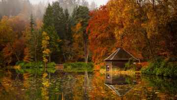
There are great places to visit near Airntully including some great rivers and streams, towns, lakes, historic buildings, ancient sites and waterfalls.
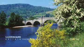
There are a several good rivers and streams in the area around Airntully like River Tay.
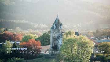
Don't miss Pitlochry, Dunkeld, and Aberfeldy's towns if visiting the area around Airntully.
There are a several good lakes in the Airntully area like Loch Faskally, and Loch Kennard.
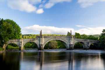
There are a several good historic buildings in the area around Airntully like Wade's Bridge.
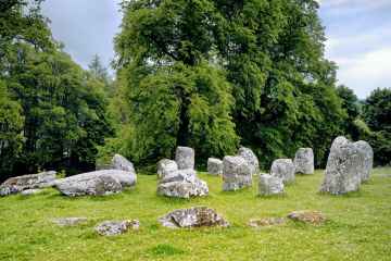
There are a number of ancient sites near to Airntully including Croftmoraig Stone Circle.
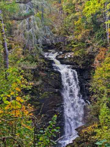
Waterfalls to visit near Airntully include Falls of Moness.
Airntully History
There are some historic monuments around Airntully:
- Middle Gourdie, souterrain 380m SSW of Prehistoric domestic and defensive: souterrain, earth-house SM6896
- Inchtuthil Farm,fort N of Prehistoric domestic and defensive: fort (includes hill and promontory fort) SM1596
- Balgarvie, unenclosed settlement 350m ESE of Prehistoric domestic and defensive: settlement SM6947
- Forehill, cairn 320m S of Prehistoric ritual and funerary: cairn (type uncertain) SM7288
- Tammieteeth, cairn 500m W of Cairnbeddie Prehistoric ritual and funerary: cairn (type uncertain) SM7286
- Cambusmichael Church Ecclesiastical: church SM5641
- Balholmie Cottage, unenclosed settlement 150m N of Prehistoric domestic and defensive: settlement SM7028
- Staredam, standing stones 80m SW of Prehistoric ritual and funerary: standing stone SM1584
- Glendelvine, souterrain 90m NW of Lodge Cottages Prehistoric domestic and defensive: souterrain, earth-house SM7135
- Millhole, unenclosed settlement 450m ESE of Prehistoric domestic and defensive: house SM7166
- Meikleour, enclosures 500m NE of Prehistoric domestic and defensive: enclosure (domestic or defensive); Prehistoric ritual and funerary: enclosure (ritual or funerary) SM7027
- Shianbank, stone circles and pillboxes 325m E of 20th Century Military and Related: Pillbox; Prehistoric ritual and funerary: stone circle or ring SM2314
- Huntingtower Castle Secular: castle SM90164
- Cairnton Cottage,cairn Prehistoric ritual and funerary: cairn (type uncertain) SM1508
- Gold Castle, enclosure 200m SW of Donald's Bank Prehistoric domestic and defensive: enclosure (domestic or defensive) SM7572
- Mill of Bonhard, unenclosed settlement and standing stone 200m S of Prehistoric domestic and defensive: settlement; Prehistoric ritual and funerary: standing stone SM6711
- Wester Drumatherty, unenclosed settlement 300m W of Prehistoric domestic and defensive: settlement SM7165
- Barrow, 420m SE of Lochton House Prehistoric ritual and funerary: barrow SM6946
- Over Benchil, standing stone 100m WSW of Prehistoric ritual and funerary: standing stone SM1574
- Sheriffton, barrow cemetery 200m NE of Prehistoric ritual and funerary: barrow SM6723
- Dunkeld, two standing stones 450m WNW of Newtyle Prehistoric ritual and funerary: standing stone SM1541
- Blackfaulds, stone circle 450m WSW of Prehistoric ritual and funerary: stone circle or ring SM7295
- Stone circle, 52m southwest of Druid's Park House Prehistoric ritual and funerary: stone circle or ring SM1571
- Loak, standing stone 470m SSE of Prehistoric ritual and funerary: standing stone SM1562
- Ninewells, kerb cairn 150m NNW of Prehistoric ritual and funerary: cairn (type uncertain) SM7126
- Castle Hill,motte W of Mains of Cargill Secular: motte SM3198
- Court Hill,cairn,Loak Prehistoric ritual and funerary: cairn (type uncertain) SM1524
- Grassy Walls, Roman camp and prehistoric settlement, Sheriffton Prehistoric domestic and defensive: settlement; Roman: camp SM4072
- Roman watch tower and unenclosed settlement, 310m NW of Strathview Cottage SM7182
- North Blackruthven,enclosures 300m NE of Prehistoric ritual and funerary: enclosure (ritual or funerary) SM3633
- Cramflat,standing stone E of Prehistoric ritual and funerary: standing stone SM1527
- Castle Hill, castle and site of church 70m NE of Clunie Church Secular: castle SM1638
- Damside, stone row 900m SW of Prehistoric ritual and funerary: stone rows SM7297
- Bonhard Park, unenclosed settlement SE of Prehistoric domestic and defensive: settlement SM6708
- Kinclaven Castle Secular: castle SM1640
- East Cult,two standing stones and cup-marked stone W of Prehistoric ritual and funerary: standing stone SM1544
- Loanleven, enclosure 300m SSW of Prehistoric ritual and funerary: enclosure (ritual or funerary) SM8755
- Balhomie, cup-marked stone 95m N of Prehistoric ritual and funerary: cupmarks or cup-and-ring marks and similar rock art SM7326
- Newbigging Farm,cup and ring marked stone 225m WSW of Prehistoric ritual and funerary: cupmarks or cup-and-ring marks and similar rock art SM1509
- Blairhall, barrow cemetery and cursus S of Prehistoric ritual and funerary: cursus/bank barrow SM6932
- Clunie Castle Secular: castle SM5508
- Lochton House, enclosure 350m ESE of Prehistoric domestic and defensive: enclosure (domestic or defensive) SM6722
- Mains of Huntingtower, henge, enclosures, pits and road WSW of Prehistoric domestic and defensive: enclosure (domestic or defensive); Prehistoric ritual and funerary: henge; Roman: road SM3630
- Wester Bonhard, unenclosed settlement 300m NNW of Prehistoric domestic and defensive: settlement SM6710
- Culthill, souterrains 100m ESE of Prehistoric domestic and defensive: souterrain, earth-house SM7129
- Gellybanks, standing stones 620m ESE of Prehistoric ritual and funerary: standing stone SM1548
- Stralochy, palisaded enclosure 300m S of Prehistoric domestic and defensive: palisaded enclosure SM7128
- Moot Hill royal assembly place and Scone Abbey, 100m NE of Scone Palace Ecclesiastical: abbey; Secular: meeting place, thingstead, moot hill SM13595
- Ring-ditch 448m S of Leys of Marlee Prehistoric ritual and funerary: barrow SM7171
- Fort, 80m SE of 65 Lumsden Crescent, Almondbank SM2641
- Colen, stone circle 750m NNE of Prehistoric ritual and funerary: stone circle or ring SM7305
- Leys of Marlee, ring-ditch 400m SSW of Prehistoric ritual and funerary: barrow SM7170
- Ardgilzean Cottage, mound SW of Prehistoric ritual and funerary: mound (ritual or funerary) SM3402
- Glendelvine House, barrow and standing stone 200m S of Prehistoric ritual and funerary: barrow SM7127
- Cambusmichael, palisaded enclosure 50m NW of Prehistoric domestic and defensive: palisaded enclosure SM7183
- Mains of Fordie, souterrain 150m NW of Prehistoric domestic and defensive: souterrain, earth-house SM7130
- Byres, ring-ditch and souterrain 330m NE of Prehistoric domestic and defensive: house SM7179
- Stralochy, palisaded enclosure 370m S of Prehistoric domestic and defensive: palisaded enclosure SM7133
- Meikle Obney, standing stone 260m E of Prehistoric ritual and funerary: standing stone SM1592
- Mains of Fordie, cairn 450m W of Prehistoric ritual and funerary: cairn (type uncertain) SM7137
- Pitsundry, standing stone 250m W of Prehistoric ritual and funerary: standing stone SM1577
- Inchtuthil, Roman fortress Roman: fort SM1606
- Hill House, unenclosed settlement 100m NE of Prehistoric domestic and defensive: settlement SM7178
- Middle Gourdie, unenclosed settlement 400m SE of Prehistoric domestic and defensive: settlement SM6894
- Glendelvine House, cairn 330m S of Prehistoric ritual and funerary: cairn (type uncertain) SM7284
- Cairn, 110m SW of Almondbank Filling Station Prehistoric ritual and funerary: cairn (type uncertain) SM2267
- Campsie Linn, grange site Ecclesiastical: grange/farm - secular buildings associated; Secular: manor house SM11143
- Mains of Gourdie, ring-ditch 120m SSW of Prehistoric domestic and defensive: hut circle, roundhouse SM6895
- Loch of Clunie,crannog 450m NNE of Clunie Castle Prehistoric domestic and defensive: crannog SM5505
- Berryhill, mortuary enclosures and pit-alignment 150m N of Prehistoric ritual and funerary: enclosure (ritual or funerary) SM7184
- New Scone,stone circle,Grey Stanes Prehistoric ritual and funerary: stone circle or ring SM1579
- Blindwells, stone circle 380m ENE of Prehistoric ritual and funerary: stone circle or ring SM7299
- Blackhillock, souterrain 50m W of Prehistoric domestic and defensive: souterrain, earth-house SM7132
- Ardlin, unenclosed settlement 700m W of Prehistoric domestic and defensive: settlement SM7186
- Murthly Castle, standing stone 300m SSW of Prehistoric ritual and funerary: standing stone SM1570
- Balcairn, cairn 350m W of Prehistoric ritual and funerary: cairn (type uncertain) SM7285
- Middle Gourdie, palisaded enclosure & unenclosed settlement 800m SW of Prehistoric domestic and defensive: palisaded enclosure SM7185
- Cambusmichael, enclosure & souterrain 100m N of Prehistoric domestic and defensive: enclosure (domestic or defensive) SM7180
- Loanhead, standing stones 450m NE of Prehistoric ritual and funerary: standing stone SM7298
- Cairn Muir, cairn 190m NW of Cairnmuir Prehistoric ritual and funerary: cairn (type uncertain) SM7287
- Leys of Marlee Farm,stone circle,Blairgowrie-Lethendy Road Prehistoric ritual and funerary: stone circle or ring SM1560
- Bertha, Roman Fort Roman: fort SM2403
- Meikleour House, motte W of Secular: motte SM7293
- Mains of Airleywight,cairn Prehistoric ritual and funerary: cairn (type uncertain) SM2898
- Inchbervis Castle Secular: castle SM3763
- Steed Stalls,Roman camp Roman: camp SM3022
- King's Stone, standing stone 90m SE of Denmarkfield Farm Prehistoric ritual and funerary: standing stone SM1556
- Kemp's Hold,fort Prehistoric domestic and defensive: fort (includes hill and promontory fort) SM6122