


Venn Down Lakes
Venn Down Lakes is a Area in the county of Cornwall.
There are great places to visit near Venn Down Lakes including some great hiking areas, country parks, towns, hills, villages, historic buildings and airports.
The area close to Venn Down Lakes boasts some of the best hiking areas including Tehidy.
There are a number of country parks near Venn Down Lakes including Tehidy Country Park, Kit Hill Country Park, and Mount Edgcumbe House and Country Park.
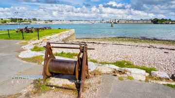
Callington, Polperro, and St Ives are some of Venn Down Lakes best towns to visit near Venn Down Lakes.
The area around Venn Down Lakes's best hills can be found at Kit Hill Country Park.
Venn Down Lakes has some unmissable villages nearby like Cremyll, and Botallack.
The area close to Venn Down Lakes boasts some of the best historic buildings including Mount Edgcumbe House and Country Park.
The area around Venn Down Lakes features a number of interesting airports including Cornwall Airport Newquay, and Land's End Airport.
Venn Down Lakes History
There are some historic monuments around Venn Down Lakes:
- Wayside cross in Lesnewth churchyard
- Bowl barrow 200m west of Tresplatt Farm
- Round cairn 625m north-west of Showery Tor
- Medieval churchyard cross 20m south of the Church of St Bruerdus, Churchtown
- Three barrows 550m ENE of Cansford
- Round 275m SSE of Little Delinuth
- An early Christian memorial stone 380m south east of Worthyvale Manor
- Forrabury Cross, 40m SSW of Forrabury church
- Medieval churchyard cross in Michaelstow churchyard
- Three prehistoric house platforms on south-east Roughtor, 1km NNW of Fernacre Farm
- Motte and bailey castle at Boscastle
- Three bowl barrows 130m east of Starapark Farm
- Round cairn 180m north of Trevarthian
- Prehistoric stone setting 62m north-west of the Stannon Stone Circle
- Stone hut circle north of Dinnever Hill, 200m WNW of the Stannon Stone Circle
- Bowl barrow 60m west of Crowdy Reservoir dam
- Round cairn 417m north-west of Showery Tor
- Round barrow cemetery including Tich Barrow 730m north east of Trehane Pool
- Prehistoric round cairn 865m NNE of Fernacre Farm
- Round cairn with central cist capstone and inner kerb 935m north-east of Camperdown Farm
- Holy well in Michaelstow churchyard
- Medieval wayside cross 320m south west of Higher Trevivian
- Trevenning Cross and post-medieval guide post, 700m south west of Trevenning village
- Medieval long-house with adjacent enclosure 1.44km NNE of Fernacre Farm
- Bowl barrow 110m north of Whitehill Farm forming part of a round barrow cemetery
- Tor cairn on Showery Tor
- Two stone hut circles 130m south east of Highsteps
- Wayside cross in St Juliot's churchyard, 10m south of the church
- Bowl barrow 250m north west of Newpark
- Two bowl barrows 625m south of Greystone Farm
- Early medieval decorated and inscribed wayside cross shaft and base on Waterpit Down, 250m WSW of Hallwell Barton Bungalow
- Kerbed cairn 415m NNW of Candra
- Promontory fort N of village
- Three bowl barrows 600m south east of Small Hill Barton
- Two small stone circles 530m ESE of King Arthur's Hall
- Hut circles near New Hall
- Two bowl barrows 660m south west of Whitehill Cottage, forming part of a round barrow cemetery
- Prehistoric irregular field system and enclosures with incorporated stone hut circle and incorporated and adjacent cairns 558m north-west of Showery Tor
- Prehistoric embanked platform cairn and linear boundary with superimposed medieval boundary and adjacent clearance cairn on Dinnever Hill
- Three platform cairns 320m south-east of Moorgate
- Round cairn 312m north-west of Showery Tor
- Stone hut circle settlement and part of a coaxial field system 940m north east of Newton
- Prehistoric round cairn with inner and outer kerbs and a central cist 485m WNW of Showery Tor
- Three bowl barrows, 60m and 250m south and 500m south west of Nettings Park
- Medieval wayside cross head 75m east of Newpark
- Roughtor holy well, 333m south-west of Showery Tor
- Ring cairn 295m north west of Candra
- Round cairn 567m north-west of Showery Tor
- Prehistoric to post-medieval settlement, and religious and funerary remains on the middle and lower slopes west and south of Roughtor
- Platform cairn on Dinnever Hill, 510m north of Camperdown Farm
- Five prehistoric round cairns and a ring cairn 920m NNE of Fernacre Farm
- Medieval tenement boundary with adjacent medieval field north of Dinnever Hill
- Round cairn 460m north of Showery Tor
- Stannon Stone Circle, prehistoric field system, hut circle settlement, cairns, cist, linear boundaries and medieval building north of Dinnever Hill
- Hut circles 330yds (300m) SW of Henneward
- Motte castle known as Bossiney Castle
- Trevena Cross
- Two adjoining prehistoric house platforms on south-east Roughtor, 960m NNW of Fernacre Farm
- Kerbed cairn on Alex Tor
- Prehistoric linear boundary, adjacent irregular aggregate field system and hut circles, incorporated cairns and medieval grave on north-west Roughtor
- Bowl barrow 490m SSW of Tregatherall Farm
- Standing stone 415m south west of Moorgate called 'Long Stone'
- Earthwork on Hill Down 500yds (450m) WSW of Tresparrett Posts
- Prehistoric and later enclosure containing a stone hut circle 1.2km NNE of Fernacre Farm
- Bowl barrow called Condolden Barrow
- Part of an early-Christian cemetery 65m north west of Tintagel church
- Kerbed cairn 500m east of Casehill
- Four prehistoric house platforms on south-east Roughtor, 938m NNW of Fernacre Farm
- Platform cairn on Priddacombe Downs
- Round 260m south west of Trengayor
- Medieval longhouse settlement (known locally as Lamlavery), and an associated field system
- King Arthur's Hall
- Two bowl barrows 595m north west of Belah Park Farm
- Dovecote 35m south of the Vicarage, Tintagel
- Prehistoric irregular field system with incorporated cairnfield and round cairn 1.08km north-west of Showery Tor
- Large regular stone circle 560m north east of Leaze
- Prehistoric and medieval settlements with fields and enclosures together with Bronze Age cairns and medieval alluvial streamwork at Garrow Tor
- The Trevia Cross, at Sportsmans
- Round called Castle Goff
- Barrow 90m E of Trelay Farm
- Prehistoric house platform on south-east Roughtor, 985m NNW of Fernacre Farm
- Deserted medieval building 55m south of Roughtor summit
- The Middle Moor Cross, 230m north-east of Camperdown Farm
- Rectangular enclosures 520m west of Rosecare Villa Farm
- Bowl barrow 660m north east of Tresoke
- Cross 410m north east of Tregrylls
- Three bowl barrows 250m north east of Lowermoor
- Trevalga Cross in Trevalga churchyard
- Prehistoric embanked avenue with incorporated funerary cist 210m WNW of Showery Tor
- Rock art at Rocky Valley, 150m north of Trevillett Mill
- Five bowl barrows south of Newton Farm forming part of a round barrow cemetery
- Slight univallate hillfort with outworks containing a medieval chapel and beacon at Helsbury Castle
- Earlier prehistoric hillfort with incorporated and adjacent cairns, chamber and medieval chapel on the summit ridge of Rough Tor and Little Rough Tor
- Prehistoric cairns and field boundary 450m south of the Louden Stone Circle
- Three wayside crosses in St Julitta's churchyard
- Round 800m south east of Pengold Farm
- Prehistoric ring cairn 810m NNE of Fernacre Farm
- Fernacre stone circle and two outlying stones
- The Castle Goff Stone and Valley Truckle Cross in St Julitta's churchyard
- Stone hut circle settlement and part of a coaxial field system at Watergate
- Holy Well 100m north east of St David's church
- Churchyard cross in the cemetery at St Teath, 60m north west of the church
- Anderton Mill Cross in St Juliot's churchyard, 10m north of the church
- Tregatheral Cross in St Juliot's churchyard, 10m east of the church
- Prehistoric to post-medieval funerary, ritual and settlement remains on and around Louden Hill
- Medieval wayside cross at Fenterleigh crossroads, 750m south-east of Bossiney
- Small multivallate hillfort called Tregeare Rounds
- Round 410m west of Kenningstockmill
- Wayside cross at Trevia Walls
- Bowl barrow 420m south east of Higher Parkwalls
- Iron Age defended settlement 170m north west of Cargurra
- Hut circle 440yds (400m) SW of Candra
- Neolithic long cairn north-east of Louden Hill
- The Louden Stone Circle, 950m ENE of Camperdown Farm
- Prehistoric standing stone 695m north-west of Showery Tor
- Romano-British and early medieval settlement, medieval church, castle and associated features on Tintagel Island and adjoining mainland
- Two hut circles 400m WSW of Furhouse
- Prehistoric hut circle and field system 440m south west of Treswallock Cottage
- Wayside cross 220m north west of Steppes Farm
- Medieval tenement boundary between Louden Hill and King Arthur's Downs
Places to see near Venn Down Lakes


Lakes near Venn Down Lakes
Rivers near Venn Down Lakes
- West Looe River
- Polperro River
- East Looe River
- Seaton
- Upper River Ruthern
- Amble
- Camel (De Lank to Stannon)
- Stannon Stream
- Lower River Camel
- St Lawrence Stream
- Issey Brook (Camel)
- Upper River Amble
- De Lank River
- Lower River Ruthern
- Demelza Stream (Ruthern)
- Polmorla Stream
- Upper River Camel
- Amble tributary (Camel)
- Allen
- Lanivet Stream
- Porth Stream
- Gannel (Upper)
- Menalhyl
- Gannel (Lower)
- Harlyn Water
- Benny Stream
- Porthcothan Stream
- Trebant Water
- Lerryn River
- Cardinham Water
- Warleggan River
- Fowey (Upper)
- Fowey (Warleggan to St Neot)
- Pont Pill
- St Neot River
- Lower River Fowey
- Crackington Stream
- Marsland Water
- Lower River Strat
- Lower River Neet
- Upper River Neet
- Jacob Stream
- Valency
- Upper River Strat
- Coombe Valley Stream
- Newlyn River
- Trevaylor Stream
- Penberth Stream
- Marazion River
- Lamorna Stream
- Roseworthy Stream
- Portreath Stream
- Red River (Upper)
- Bolingey Stream
- Red River (Lower)
- Hayle
- Angarrack Stream
- Holywell Stream
- Kestle Stream
- Upper River Allen (Fal)
- Kenwyn
- Kennal
- Zelah Brook
- Brighton Stream
- Hicks Mill Stream
- Gwindra Stream
- Tresillian River (Lower)
- Upper River Fal
- Calenick Stream
- Trevella Stream
- Tresillian River (Upper)
- Lower River Allen (Fal)
- Lower River Fal
- Upper Carnon River
- Lower River Carnon
- Bokiddick Stream
- Crinnis River
- St Austell River
- Caerhays Stream
- Par River (Upper)
- Par River (Lower)
- Tywardreath Stream
- Carminowe Creek
- Gunwalloe Stream
- Cury River
- Helford River
- Manaccan River
- Poltesco River
- Lestraines River
- Lower River Cober
- Porthleven Stream
- Upper River Cober
- Gweek River
- Upper River Inny
- Penpont Water
- Cotehele Stream
- Lowley Brook
- Lower River Inny
- Lower River Tamar
- Upper River Lynher
- Tiddy
- Withey Brook
- Lower River Lynher
- Tala Water
- Canworthy Water
- Carey
- Tamar (River Ottery to River Deer)
- Tamar (Small Brook to River Deer)
- Upper River Ottery
- Kensey
- Tamar (Small Brook to Lamberal Water)
- Small Brook (Tamar)
- Claw
- Tamar (River Ottery to River Lyd)
- Lower River Ottery
- Upper River Tamar
- Caudworthy Water
- Deer
- Lamberal Water
- Bolesbridge Water
- Derril Water
- Middle River Ottery


