St Ives
St Ives
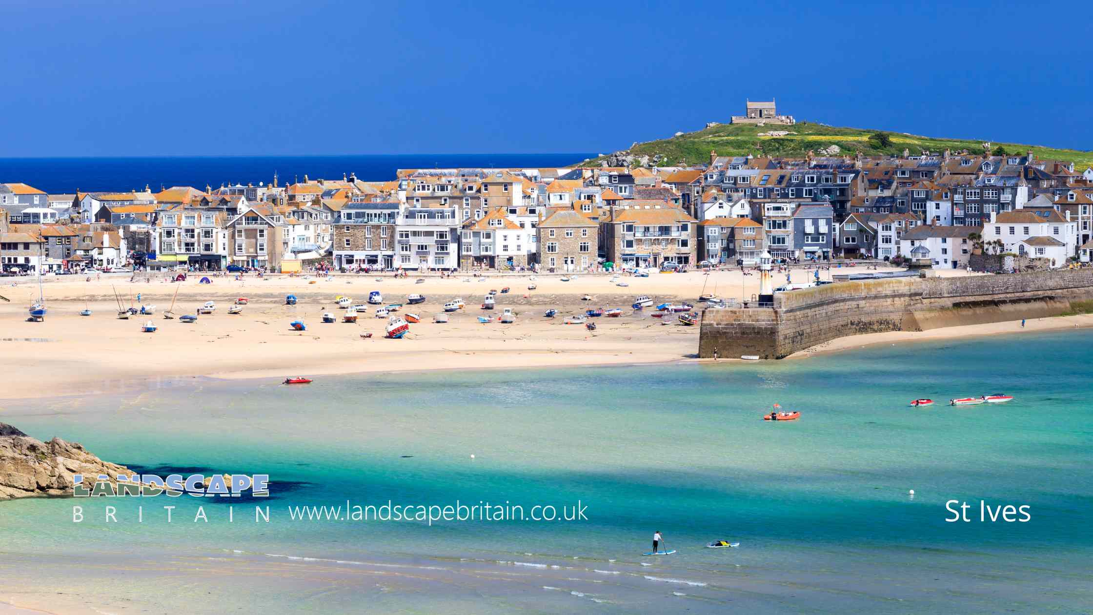
St Ives is a charming seaside town located in Cornwall, England, known for its breathtaking natural beauty, picturesque harbor, and thriving art scene. With its narrow, winding cobblestone streets, whitewashed cottages, and spectacular views over the Celtic Sea, it presents a quintessentially British coastal experience.
The town’s history is deeply rooted in fishing and mining, but over the centuries, it has transformed into a creative hub, attracting artists from around the globe. This can be seen in the renowned Tate St Ives, an art gallery showcasing works of modern British artists with a connection to the area. Nearby is the Barbara Hepworth Museum and Sculpture Garden, which celebrates the life and work of the acclaimed 20th-century sculptor in her former studio and garden.
St Ives is equally famous for its pristine sandy beaches, including Porthmeor Beach, popular among surfers, and the more sheltered Porthminster Beach. Its temperate, oceanic climate, among the mildest in the UK, makes it a favorite holiday destination. The surrounding countryside, with its cliffs and coves, offers plenty of opportunities for hiking and bird watching.
The town itself is brimming with charming cafés, independent boutiques, and seafood restaurants, where you can sample locally caught fish and Cornish specialties. The sense of community is also strong in St Ives, with local festivals like the Feast of St Ives in February and September Festival, a two-week celebration of music and arts, adding to the vibrant atmosphere.
Whether you’re an art enthusiast, nature lover, or simply looking for a tranquil retreat, St Ives offers a unique blend of cultural richness and natural beauty that captivates visitors year-round.
Created: 21 June 2023 Edited: 29 November 2023
St Ives
Local History around St Ives
There are some historic monuments around including:
Round cairn 135m west of Little CarnaquiddenWayside cross 65m west of St Uny's Church, LelantBowl barrow 260m SSE of Zennor QuoitRound barrow 300yds (270m) SSE of PolhigeyWayside cross 2m south of St Uny's Church, LelantCross at TreassoweSt Erth Churchtown crossStanding stone 340m south of Trye FarmChurchyard cross 25m south of St Uny's Church, LelantNeolithic hilltop enclosure and Iron Age defended settlement known as Trencrom CastleRound 450yds (405m) NW of Lower Chellew FarmWayside cross 70m south of St Uny's Church, LelantWayside cross 40m west of St Uny's Church, LelantWayside cross called Crowlas Cross, 230m north east of Lower TregenderCourtyard house 280m north west of Middle CarnaquiddenRound cairn 180m WSW of Higher ConquerEntrance grave known as Zennor Quoit 600m north-east of Foage FarmStone hut circle settlement, round cairn and part of a prehistoric field system 500m south of Foage FarmThree wayside crosses in the churchyard of St Sennara's ChurchChurchyard cross and wayside cross in St Erth's churchyardPenbeagle CrossTwo courtyard houses and two stone hut circles 470m north east of NewmillCourtyard house 150m north east of Trye FarmHut circle settlement at Sperris Croft 500yds (460m) SE of Tregerthen CottageKerbed cairn 660m WNW of Foage FarmStanding stone 140m north west of Beersheba FarmWayside cross in Ludgvan churchyard, 6m south of the churchHut circles, Higher BussowSea Lane Cross, LelantStone hut circle 730m west of Foage FarmRound 300yds (270m) NE of NewmillDovecote called the 'Culver House', 330m SSW of Lower Bussow FarmTwo cist graves 500yds (460m) NE of Tregerthen CottageWayside cross in Ludgvan churchyard, 10m south east of the churchA small multivallate hillfort known as 'Castle-an-Dinas' which contains an 18th century folly called 'Roger's Tower'Churchyard cross in St Ia's churchyardAncient house and enclosures 250yds (230m) N of Mulfra FarmSettlement 450yds (400m) NW of Middle CarnaquiddenTwo kerbed cairns on Trendrine HillPortal dolmen called Sperris QuoitRectangular enclosures 700yds (640m) E of TregerthenMedieval wayside cross at Whitecross, near CrowlasWayside cross in Ludgvan churchyard, 8m east of the churchWayside cross immediately south of St Towennicus' ChurchWayside cross in Lelant Lane, 670m north west of St Uny's ChurchChysauster courtyard house settlement, fogou, round cairn and part of a prehistoric field systemA round, courtyard house settlement and two stone hut circles 400m north east of Trye FarmBrunnion Cross, at Brunnion CarnCircular enclosure 385m NE of Higher Trenowin.


