Botallack
Botallack
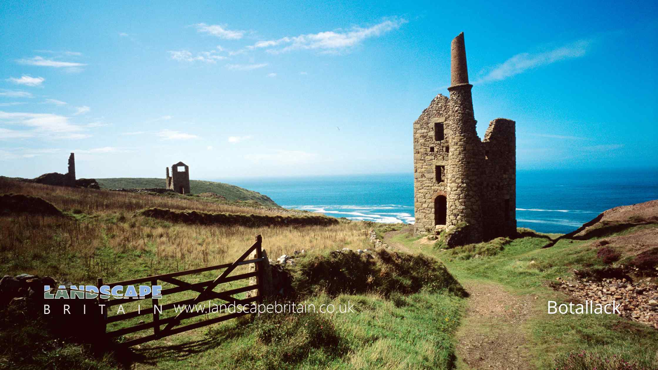
Botallack is a historic village situated on the western coastline of Cornwall, England. It’s best known for its rich industrial heritage, with deep roots in the region’s storied tin and copper mining industry. Nestled among the rugged landscapes and dramatic cliff faces, Botallack provides a glimpse into Cornwall’s past that makes it a must-visit location for history enthusiasts.
The village’s most iconic feature is the Botallack Mine, a UNESCO World Heritage site. This old tin mine, which extends under the Atlantic Ocean, is a symbol of the area’s industrial heritage. Its most notable features are the Crowns Engine Houses, two distinct structures precariously perched on the edge of the cliffs, providing a stark contrast with the wild Atlantic Ocean. These structures, now maintained by the National Trust, offer an insight into the often perilous conditions miners worked in.
The scenery around Botallack is breathtakingly beautiful, with stunning ocean views and rugged landscapes that have been shaped by centuries of mining activities. The South West Coast Path, which runs through the area, is a popular route for walkers who want to enjoy the natural beauty of the area. This is also a perfect place for bird watchers and nature lovers due to its diverse wildlife.
Moreover, Botallack has found fame in recent years as a filming location for the hit BBC drama Poldark, which showcased the beauty and history of the Cornish coast. The village is quaint and tranquil, with a small population, offering a taste of Cornish rural life.
Botallack embodies Cornwall’s industrial past and natural beauty, offering a unique blend of history, rugged landscapes, and tranquil rural life. Whether you’re a fan of history, nature, or even drama series, Botallack is a worthwhile destination.
Botallack is in Cornwall AONB, a designated Area of Outstanding Natural Beauty.
Created: 21 June 2023 Edited: 29 November 2023
Botallack
Local History around Botallack
There are some historic monuments around including:
Entrance grave 290m south west of Brane End FarmPart of a prehistoric field system at Tor NoonFogou 70m north of Pendeen Manor FarmEnclosure 220yds (200m) NE of TreveanBarrow 800yds (730m) WNW of Boswens FarmHut circle on Carnyorth Common 200yds (180m) W of Carn KenidjackCarnyorth Circles, Carnyorth FarmMedieval chapel called St Helen's Chapel with a dwelling and enclosure at Cape CornwallBarrow 250yds (230m) W of Higher BotallackTwo hut circles 380yds (350m) NE of TreveanKerbed cairn 225m south of Heather FarmLong stone W of Boswens CommonEntrance grave 140m east of KerrowMedieval playing place known as Plain an Gwary, St JustChurchyard cross in St Buryan churchyardTwo ring cairns 110m north east of ChycarneGroup of round barrows on Truthwall CommonMulti-period archaeological landscape 430m north of TredinneyWayside cross immediately north east of St John the Baptist's ChurchBotrea barrowsCliff castle known as Maen CastleThe Ballowall Barrow incorporating entrance grave, cairn, ritual pits and cists 420m WSW of Bollowal FarmChurchyard cross in St Just's churchyard, 10m west of the churchAn entrance grave re-used as a kerbed cairn with cist known as 'Chapel Carn Brea'Medieval wayside cross 35m SSW of Pendrea Cottage, south west of St BuryanIron Age to Roman settlement with incorporated fogou and adjacent post-medieval cottage at Carn EunyThree bowl barrows 380m south east of BryndowrTwo barrows on Woon Gumpus Common 700yds (640m) NNW of Boslow FarmBoslow Cross 550yds (500m) NW of Boslow FarmStone hut circle 390m south east of Little Brea FarmTin streamworks 245m south east of Higher NumphraRound cairn 230m SSW of Higher TregiffianTwo kerbed cairns 240m WSW of BoscreganTin mine calciner at Botallack MineEnclosed stone hut circle settlement at Chygwidden Vean, 250m east of Land VueKerbed cairn 365m north west of TredinneyRing cairn 305m NNW of Joppa FarmTrevescan Cross 340m SSW of Sennen ChurchRound 340m south east of TreveanCourtyard house settlement 335m south of Nanjulian FarmWayside cross 260m south east of Mayon FarmEnclosure containing eight round cairns known as Bartine Castle, 460m south east of Higher BartinneyIron Age defended settlement, 330m south east of Caer Bran FarmRound cairn and medieval settlement 150m south of Solomons IsleWatermill near Bosigran CastleRound barrow 550yds (500m) N of ChycarneField system on Truthwall CommonChapel 140m south west of BosenceHigher Levant MineTrevorgans Cross 375m east of Crows-an-wraStanding stone 200yds (180m) W of ChycarneWayside cross in St Sennen's churchyard, 6m north of the churchStone cross base 450yds (405m) NW of Santry FarmIron Age defended settlement 460m south east of Caer Bran FarmRound barrow 200yds (180m) NNW of Long StoneBarrow 100yds (90m) SE of Halgolluir FarmRound, courtyard house settlement and field system 140m WNW of GoldherringTwo large regular stone circles 290m north east of Hailglower FarmWayside cross 200m north west of PendreaWayside cross at Nanquidno FarmTwo stone hut circle settlements and part of an associated field system 370m south west of BoswensGeevor MineKerbed cairn 100m NNW of Chapel Carn BreaHoled stones on Kenidjack CommonHut circle 280yds (250m) SW of TrevarthenEnclosed hut circle settlement, 500m north-west of Jericho FarmTwo kerbed cairns 285m north east of Higher BotallackCross slab at parish churchCrows-an-wra medieval wayside cross and a turnpike milestone.St Buryan churchtown crossMedieval wayside cross 150m ESE of Lower AlsiaWayside cross in St Just Vicarage gardenChun Downs prehistoric landscape complex, incorporating Chun Cromlech, Chun Castle, and barrow 200yds (180m) SW of Chun FarmField system on Dry CarnPart of a prehistoric field system and medieval strip fields 250m south west of Higher BartinneyFogou at Lower BoscaswellLeswidden Stone, 370m south west of LeswiddenStone hut circle 40m west of Carnyorth FarmPromontory fort called Kenidjack CastleMegalithic tomb 220yds (200m) SW of TrevarthenA kerbed cairn with cists, 450m north east of Trevedra FarmPromontory fort called Bosigran CastleRound cairn on Carn PolpryWayside cross-head in St Sennen's churchyard, 10m south of the churchWayside cross 310m WNW of Little BoswarthenLarge regular stone circle called Boscawen-Un with two outlying standing stones west of Boscawen Noon FarmCourtyard house settlement 315m NNE of Botrea FarmPart of a field system and cairn field 375m west of Bojuthnoe FarmCourtyard house settlement known as Bosullow Trehyllys, 515m north east of Chun CastleCroftoe British villageStanding stone 230m west of the Old ManorFogou 70m west of Higher Bodinnar.


