Elsted
Elsted is a Village in the county of West Sussex.
Elsted postcode: GU29 0JZ
There are great places to visit near Elsted including some great towns, country parks, woodlands and airports.
There are a several good towns in the Elsted area like Chichester, and Crawley.
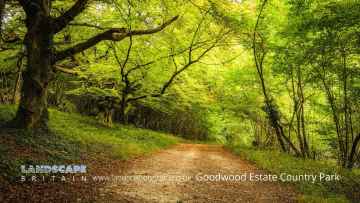
Goodwood Country Park, and Buchan Country Park are some of Elsted best country parks to visit near Elsted.
The area around Elsted's best woodlands can be found at Goodwood Country Park.
The area around Elsted features a number of interesting airports including Gatwick Airport, Shoreham Airport, and Chichester/Goodwood Airport.
Elsted History
There are some historic monuments around Elsted:
- Cross dyke on Heathbarn Down, 520m south east of Lodge Hill Farm
- Two bowl barrows 380m south of Wenham Cottage: part of West Heath Common round barrow cemetery
- Cross dyke on northern spur of Bow Hill, 500m north east of the Tansley Stone
- Devil's Ditch, section extending 380yds (350m) NW from The Cottage, Goodwood Park
- Bell barrow 300m north east of the Club House on Petersfield Heath Common, part of the Petersfield Heath Group
- Cross dyke on south eastern spur of Bow Hill, 900m south west of the Tansley Stone
- The Devil's Jumps round barrow cemetery
- Harting Beacon: a hilltop enclosure, Anglo-Saxon burial mound and telegraph station on Beacon and Pen Hills
- Bowl barrow and two saucer barrows 440m south east of the Club House on Petersfield Heath common, part of the Petersfield Heath Group
- Bowl barrow 180m north east of Foxcombe House
- Disc barrow 460m south of the Club House on Petersfield Heath Common, part of the Petersfield Heath Group
- Three bowl barrows 500m NNE of Fitzhall: part of Fitzhall Heath round barrow cemetery
- Bowl barrow 280m WNW of Fitzhall Lodge: part of Fitzhall Heath round barrow cemetery
- Durford Bridge
- Bowl barrow on Weavers Down, 630m NNW of Allington Cottage
- Two bowl barrows 150m south east of the Club House on Petersfield Heath Common, part of the Petersfield Heath Group
- Three bowl barrows on Trotton Common
- Habin Bridge
- Bowl barrow on Linch Down
- Bowl barrow on Bow Hill, 290m south east of the Tansley Stone
- A deserted medieval village and post-medieval farm buildings, 1.4km north-west of Yew Tree Cottage
- Two bell barrows, two pond barrows and a cross dyke on Bow Hill: part of The Devil's Humps round barrow cemetery
- Bowl barrow on Charlton Down, 350m south of Goodwood racecourse
- Trotton Bridge
- Bowl barrow on Trotton Common, 500m south of Trotton Nurseries
- Ruined church
- Earthwork on Farther Commons
- Platform barrow on Bepton Down
- Bowl barrow 490m south of the Club House on Petersfield Heath Common, part of the Petersfield Heath Group
- Flint mines on Bow Hill
- Two bowl barrows 300m south east of the Club House on Petersfield Heath Common, part of the Petersfield Heath Group
- Four bowl barrows on Weavers Down, 650m north west of The Sanctuary
- A multiple enclosure fort known as Goosehill Camp and a prehistoric linear boundary on Bow Hill
- The Trundle hillfort, causewayed enclosure and associated remains at St Roche's Hill
- Bowl barrow 230m south east of the Club House on Petersfield Heath Common, part of the Petersfield Heath Group
- Bowl barrow 190m north east of the Club House on Petersfield Heath Common, part of the Petersfield Heath Group
- Torberry hillfort
- Part of a Roman road 250m south of Stubb Hill Farm
- Hilltop enclosure and linear boundary on Bow Hill
- Disc barrow 310m east of the Club House on Petersfield Heath Common, part of the Petersfield Heath Group
- Oval barrow, the north-western of two on Stoughton Down
- Bowl barrow on Didling Hill
- Linear boundary 310m north west of the Tansley Stone on Bow Hill
- Bowl barrow 250m north-west of Fitzhall Lodge: part of Fitzhall Heath round barrow cemetery
- Oval barrow, the south-eastern of two on Stoughton Down
- Bowl barrow 480m south of Irongates Lodge
- Three bowl barrows on Fitzhall Rough, 200m north-east of Fitzhall: part of Fitzhall Rough round barrow cemetery
- A saucer barrow and a bowl barrow on Bow Hill, 270m south east of the Tansley Stone
- Romano-British villa and traces of medieval occupation at Pitlands Farm, Up Marden
- Bowl barrow on Bepton Down
- Bowl barrow north west of Telegraph House
- Bexley Bushes earthworks
- Oval barrow 700m SSE of Locksash Farm
- Durford Abbey
- Medieval chapel near Chilgrove, 295m north-west of Yewtree Cottage
- Two round barrows in Grevitts Copse
- Twin bowl barrow 325m south east of the Club House on Petersfield Heath Common, part of the Petersfield Heath Group
- Hammer Wood hillfort
- Two bowl barrows on Iping Common, 520m SSW of Crossways Cottages
- Multiple cross dyke on Harting Downs, 570m east of Down Place
- Bowl barrow 160m south of the Club House on Petersfield Heath Common, part of the Petersfield Heath Group
- Twin bell barrow and a bowl barrow on Asdean Down
- Bowl barrow 220m WNW of Fitzhall Lodge: part of Fitzhall Heath round barrow cemetery
- Cross dyke on West Harting Down, 650m south west of Foxcombe Farm
- Two bowl barrows on Iping Common, 350m south west of Crowshole Farm
- Iping Bridge
- Romano-British villa, with cemetery and associated building, at Batten Hanger, 600m south east of Hill Lands Farm
- The Vandalian Tower, Up Park
- Roman road at Chapel Common
- Cross dyke on St Roche's Hill, 480m north west of The Trundle hillfort
- Bowl barrow on Weavers Down, 850m NNE of Wylds Farm
- Two bowl barrows and a saucer barrow 360m south of the Club House on Petersfield Heath Common, part of the Petersfield Heath Group
- Bevis's Thumb long barrow, 370m west of Fernbeds Farm
- Flint mine on Stoke Down, immediately north of Stoke Clump
- Saucer barrow 220m south of the Club House on Petersfield Heath Common, part of the Petersfield Heath Group
- Iron Age farmstead and Roman villa, 360m SSW of Brickkiln Farm
- Bowl barrow on Fitzhall Rough, 330m ENE of Fitzhall: part of Fitzhall Rough round barrow cemetery
- Bowl barrow in Edgar Plantation
- North Park Furnace: iron works and gun foundry
- Bell barrow north-west of Brooms Farm
- Twin bowl barrow 660m east of the Club House on Petersfield Heath Common, part of the Petersfield Heath Group
- Bowl barrow 240m east of the Club House on Petersfield Heath Common, part of the Petersfield Heath Group
- An Itford Hill style settlement in Kingley Vale
- Woolbeding Bridge
- Devil's Ditch, section extending 530yds (480m) W from Lavant Lodge
- Two bowl barrows on Bow Hill forming part of The Devil's Humps round barrow cemetery
- Bowl barrow on Charlton Down, 250m south of Goodwood racecourse
- Devil's Ditch, section extending 1100yds (1000m), Valdoe Wood
- Roman road across Iping Common and bowl barrow 180m north west of Fitzhall Lodge: part of Fitzhall Heath round barrow cemetery
- Medieval moated site in Parlour Copse
- Mansio at Weston's Farm
- Bowl barrow on Cocking Down
- Bowl barrow on Goldrings Warren
- Cross dyke on north eastern spur of Bow Hill, 150m south east of the Tansley Stone
- Bowl barrow on Treyford Hill
- Cross dyke on St Roche's Hill, 410m and 425m north east of The Trundle hillfort
- Linear boundary on Stoke Down, 800m north of West Stoke House
- Roman villa on Warren Down
- Bowl barrow 520m north of Fitzhall: part of Fitzhall Heath round barrow cemetery