

East Hagbourne
East Hagbourne is a Town in the county of Oxfordshire.
There are great places to visit near East Hagbourne including some great ancient sites, cities and shopping centres.
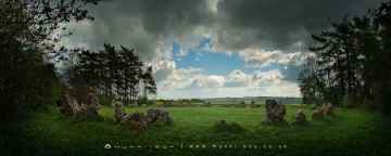
The Rollright Stones, The King Stone, The Whispering Knights, and The Kings Men are some of East Hagbourne best ancient sites to visit near East Hagbourne.
The area around East Hagbourne's best cities can be found at Oxford.
There are a number of shopping centres near to East Hagbourne including Westgate Oxford.
East Hagbourne History
There are some historic monuments around East Hagbourne:
- Bowl barrow 500m west of Churn Park Cottage
- Settlement site
- Brightwell Barrow
- Round barrow cemetery at Fullamoor Plantation
- Ock Bridge
- Settlement site E of Goose Acre Farm
- Coscote village cross
- Grim's Ditch: section W of Chilton Plantation
- Settlement site N of Cow Lane
- East Hagbourne village cross
- Settlement site N of Thames
- Barton (remains of)
- Bell barrow NE of Oven Bottom
- Blewburton Hill
- Roman town
- Grim's Ditch: section 1 mile long E from Southfield Shaw to Streatley parish boundary
- Settlement sites N of Wick Hall
- Lowbury Hill camp
- Settlement site
- Site of Roman kilns
- Dovecote 60m north of Place Manor Cottage
- Dovecote at Culham Manor, 110m south west of St Paul's Church
- Barrow N of Ridgeway, Hodcott Down
- Ring ditches, cursus, enclosures and settlement site
- Grim's Ditch; section W of Chilton Plantation
- Long barrow on Sheep Down, 1km north of East Ilsley
- Chislehampton Bridge
- Perborough Castle
- Grim's Ditch: section 1200yds (1100m) long from Chilton Plantation to Ridge Hill
- Church Piece cemetery site
- Anglo-Saxon great hall complex and Roman settlement features at Long Wittenham
- Grim's Ditch; section 1200yds (1100m) long from Chilton Plantation to Ridge Hill
- Grim's Ditch; section on Aston Upthorpe Down
- Churn Knob bell barrow and adjacent bowl barrow on Churn Hill
- Abingdon Bridge including Maud Hale's Bridge
- Bowl barrow 310m south east of Lower Chance Farm
- Sutton Wick settlement site
- Abingdon Abbey (remains of)
- Bowl barrow on Barrow Hill
- Bowl barrow in the north-west corner of Town Copse
- Two bowl barrows and a pair of confluent barrows 270m north east of Churn Farm
- Two round barrows 520m and 550m north of Lower Chance Farm
- Settlement site at Northfield Farm
- Culham Bridge
- Castle mound at Fitzharris
- Motte castle immediately west of St John the Baptist's Church
- East Ilsley Down round barrows
- Grim's Ditch: two sections in Portobello Wood, Holies Shaw and High Holies Wood Gap
- Settlement site SE of church
- Bowl barrow 700m north west of Churn Farm
- East Hendred Down bowl barrow
- Sinodun Hill camp
- Carfax Conduit, 540m south west of Nuneham House
- Dike Hills
Places to see near East Hagbourne

Lakes near East Hagbourne
Canals near East Hagbourne
Rivers near East Hagbourne
- Thame upstream of Aylesbury
- Cuttle Brook
- Dorton, Chearsley and Waddesdon Brooks
- Stoke Brook Aylesbury
- Baldon Brook (South of Oxford)
- Holton Brook and tributaries
- Chinor Brook and Sydenham Brook
- Kingsey Cuttle Brook and tributaries at Thame
- Latchford Brook at Tetsworth
- Hardwick Brook (Source to Thame)
- Lewknor Brook
- Thame (Scotsgrove Brook to Thames)
- Scotsgrove Brook (upstream Kingsey Cuttle Brook)
- Peppershill and Shabbington Brooks
- Worminghall Brook and tributaries
- Thame (Aylesbury to Scotsgrove Brook)
- Haseley Brook
- Chalgrove Brook
- Bear Brook and Wendover Brook
- Fleet Marston Brook, Denham Brook, Pitchcott Brook west
- Berrick Stream and Lady Brook
- Wye (High Wycombe fire station to Thames)
- Sulham Brook
- Hamble Brook
- Mill Brook and Bradfords Brook system, Wallingford
- Cholsey Brook and tributaries
- Hughenden Stream
- Ewelme Stream (Source to Thames)
- Ewelme Stream (Source to Thames)
- Thames (Reading to Cookham)
- Wye (Source to High Wycombe fire station)
- Thames Wallingford to Caversham
- Pang
- Letcombe Brook
- Ock and tributaries (Land Brook confluence to Thames)
- Sandford Brook (source to Ock)
- Frilford and Marcham Brook
- Childrey Brook and Norbrook at Common Barn
- Ock (to Cherbury Brook)
- Childrey and Woodhill Brooks
- Stutfield Brook (source to Ock)
- Ginge Brook and Mill Brook
- Thames (Evenlode to Thame)
- Moor Ditch and Ladygrove Ditch
- Northfield Brook (Source to Thames) at Sandford
- Cow Common Brook and Portobello Ditch
- Cherwell (Bletchingdon to Ray)
- Bloxham Brook (Source to Sor Brook)
- Highfurlong Brook (to Cherwell)
- Hanwell Brook
- Tadmarton Stream (Source to Sor Brook)
- Upper Swere (Source to Wigginton)
- Hook Norton Brook (Source to Swere)
- Sor Brook (Broughton to Cherwell)
- Farthinghoe Stream (Source to Cherwell) and tributaries
- Swere (Wigginton to Cherwell)
- Ockley Brook and Croughton Brook (Source to Cherwell)
- Ashby Brook (Source to Cherwell)
- Bayswater Brook
- Deddington Brook (Source to Cherwell)
- Sor Brook (Source to Broughton)
- Cherwell (Ray to Thames) and Woodeaton Brook
- Cherwell (Source to Trafford Bridge)
- Chacombe Brook (Source to Cherwell)
- Cherwell (Ashby Brook to Cropredy)
- Clayton and Wormleighton Brook, Source to Highfurlong Brook
- Cherwell (Cropredy to Nell Bridge)
- Shutford Stream (Source to Sor Brook)
- Cherwell (Nell Bridge to Bletchingdon)
- Littlestock Stream to tributary of Evenlode at Shipton
- Evenlode (Source to Four Shires S) and Longborough Stream
- Glyme (Enstone to Dorn)
- Little Compton Brook and tributaries (Source to Evenlode)
- Evenlode (Bledington to Glyme confluence)
- Glyme (Dorn confluence to Evenlode)
- Evenlode (Compton Bk to Bledington Bk) and 4 Shires
- Heythorpe Stream and tributaries
- Cornwell Brook and tributaries (Source to Evenlode)
- Coldron and Taston Brooks
- Sars Brook (source to Evenlode downstream Bledington)
- Bledington Brook (Source to Evenlode)
- Evenlode (Glyme to Thames)
- Glyme (Source to Enstone)
- Westcote Brook (source to Evenlode at Bledington)
- Dorn (Source to Glyme)


