


Combe
Combe is a Village in the county of Oxfordshire.
Combe postcode: OX29 8
There are great places to visit near Combe including some great ancient sites, cities, shopping centres, towns and historic buildings.
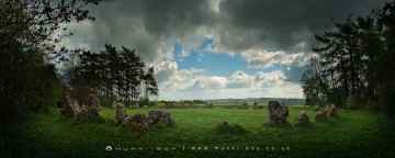
There are a several good ancient sites in the Combe area like The Rollright Stones, The King Stone, The Whispering Knights, and The Kings Men.
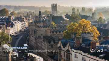
Places near Combe feature a number of interesting cities including Oxford.
There are a several good shopping centres in the area around Combe like Westgate Oxford.
Combe is near some unmissable towns like Banbury,
Places near Combe feature a number of interesting historic buildings including Upton House.
Combe History
There are some historic monuments around Combe:
- Taston village cross
- Bowl barrow 350m south west of Furze Platt Farm in Blenheim Great Park
- Thrupp Cross
- 80m section of the north Oxfordshire Grim's Ditch 150m WSW of Ditchley Gate in Blenheim Park
- Section of the north Oxfordshire Grim's Ditch 350m ENE of Ditchley House
- Rectangular earthwork enclosure in Hill Wood, 650m south east of Grimsdyke Farm
- Section of the north Oxfordshire Grim's Ditch and a section of Akeman Street Roman road immediately south east of North Lodge in Blenheim Great Park
- Swinford Bridge
- Section of the north Oxfordshire Grim's Ditch running into the northern edge of Shilcott Wood on the Ditchley Estate
- Rectangular earthwork, Hensington
- North Leigh Roman villa 300m NNE of Upper Riding Farm
- Ring ditch near Long Hanborough
- Over Chalford medieval settlement
- 380m section of the north Oxfordshire Grim's Ditch 200m ENE of Kiddington Lodge
- Bladon camp: a hillfort on Bladon Heath
- Section of the north Oxfordshire Grim's Ditch running east from the River Evenlode opposite Cornbury Park
- Sites discovered by aerial photography, near Foxley Farm
- Pair of Bronze Age round barrows and surrounding Civil War fieldworks 180m north-west of Park Farm
- Earthwork 300m south west of Fair Rosamund's Well, Blenheim Park
- Bowl barrow 80m south east of Spelsburydown Farm barns
- 240m section of the north Oxfordshire Grim's Ditch between Grim's Dyke Farm and the B4437 Charlbury to Woodstock road
- A pair of Roman camps and a section of a post-medieval sunken road situated in the north eastern corner of Cornbury Park
- Ten medieval pillow mounds and part of an associated enclosure 300m north west of Combe Lodge
- 1100m section of the north Oxfordshire Grim's Ditch at Model Farm on the Ditchley Park Estate
- Oaklands Farm Roman villa
- Hoar Stone portal dolmen situated in Enstone Firs
- Bowl barrow in Kingswood Brake, 450m WNW of Wood Farm
- Long barrow 730m south west of Enslow Bridge
- Nether Chalford medieval settlement
- Bowl barrow 500m south west of Hill Farm, Lidstone
- Eynsham Abbey (site of)
- Ditchley Park Roman villa and part of an associated field system 450m ENE of Lodge Farm
- The remains of a medieval moated manor, priory, settlement and associated features, Cogges
- Water gardens, avenue and an associated earthwork, east of Court Farm
- Roman villa
- Gagingwell cross, 80m west of Abbey Farm
- Lee's Rest Earthwork: a probable Romano-Celtic temple 200m north east of Lee's Rest Farm
- Medieval settlement and church of Asterleigh
- Butter cross
- Eynsham market cross
- 90m section of the north Oxfordshire Grim's Ditch 350m south of Grim's Dyke Farm
- Pump Copse earthwork
- Rectangular enclosure near New Inn
- Barrow Place earthwork, 370m south west of Lodge Farm, Ditchley
- Blenheim Villa, a Roman villa and associated field system 200m north east of Little Cote
- Great kitchen of manor house
- Section of the north Oxfordshire Grim's Ditch west of Common Farm
- 1km section of the north Oxfordshire Grim's Ditch running from Out Wood to Berring's Wood
- Bowl barrow 150m north-west of North Lodge, Cornbury Park
- Bowl barrow 270m east of Spelsburydown Farm barns
- Bowl barrow situated in Round Clump, Ditchley Park
- 900m section of the north Oxfordshire Grim's Ditch 200m north of Grim's Dyke Farm, running north into Hark Wood
- Fawler Roman villa
- Copping Knoll bowl barrow 200m south of Rose Cottage
- Civil War artillery fieldwork 370m NNW of Park Farm, Cornbury Park
- Dovecote at Rousham House
- Bishop of Winchester's Palace, 90m east of St Mary's Church
- Walcot ornamental fishponds and garden earthworks
- Stonesfield Roman villa
- Barn at Rectory Farm, Church Enstone
- Taston standing stone 12m north of Taston village cross
- Shipton-on-Cherwell churchyard cross
- 145m section of the north Oxfordshire Grim's Ditch situated 200m west of Grimsdyke Farm
- Long barrow 250m south of Ellen's Lodge in Shilcott Wood on the Ditchley Park Estate
- Callow Hill Roman villa
- Bowl barrow 60m north of Wood Farm
- Linear earthworks east of Callow Hill Roman villa forming part of the north Oxfordshire Grim's Ditch
Places to see near Combe


Lakes near Combe
Canals near Combe
Rivers near Combe
- Thame upstream of Aylesbury
- Cuttle Brook
- Dorton, Chearsley and Waddesdon Brooks
- Stoke Brook Aylesbury
- Baldon Brook (South of Oxford)
- Holton Brook and tributaries
- Chinor Brook and Sydenham Brook
- Kingsey Cuttle Brook and tributaries at Thame
- Latchford Brook at Tetsworth
- Hardwick Brook (Source to Thame)
- Lewknor Brook
- Thame (Scotsgrove Brook to Thames)
- Scotsgrove Brook (upstream Kingsey Cuttle Brook)
- Peppershill and Shabbington Brooks
- Worminghall Brook and tributaries
- Thame (Aylesbury to Scotsgrove Brook)
- Haseley Brook
- Chalgrove Brook
- Bear Brook and Wendover Brook
- Fleet Marston Brook, Denham Brook, Pitchcott Brook west
- Berrick Stream and Lady Brook
- Wye (High Wycombe fire station to Thames)
- Sulham Brook
- Hamble Brook
- Mill Brook and Bradfords Brook system, Wallingford
- Cholsey Brook and tributaries
- Hughenden Stream
- Ewelme Stream (Source to Thames)
- Ewelme Stream (Source to Thames)
- Thames (Reading to Cookham)
- Wye (Source to High Wycombe fire station)
- Thames Wallingford to Caversham
- Pang
- Letcombe Brook
- Ock and tributaries (Land Brook confluence to Thames)
- Sandford Brook (source to Ock)
- Frilford and Marcham Brook
- Childrey Brook and Norbrook at Common Barn
- Ock (to Cherbury Brook)
- Childrey and Woodhill Brooks
- Stutfield Brook (source to Ock)
- Ginge Brook and Mill Brook
- Thames (Evenlode to Thame)
- Moor Ditch and Ladygrove Ditch
- Northfield Brook (Source to Thames) at Sandford
- Cow Common Brook and Portobello Ditch
- Cherwell (Bletchingdon to Ray)
- Bloxham Brook (Source to Sor Brook)
- Highfurlong Brook (to Cherwell)
- Hanwell Brook
- Tadmarton Stream (Source to Sor Brook)
- Upper Swere (Source to Wigginton)
- Hook Norton Brook (Source to Swere)
- Sor Brook (Broughton to Cherwell)
- Farthinghoe Stream (Source to Cherwell) and tributaries
- Swere (Wigginton to Cherwell)
- Ockley Brook and Croughton Brook (Source to Cherwell)
- Ashby Brook (Source to Cherwell)
- Bayswater Brook
- Deddington Brook (Source to Cherwell)
- Sor Brook (Source to Broughton)
- Cherwell (Ray to Thames) and Woodeaton Brook
- Cherwell (Source to Trafford Bridge)
- Chacombe Brook (Source to Cherwell)
- Cherwell (Ashby Brook to Cropredy)
- Clayton and Wormleighton Brook, Source to Highfurlong Brook
- Cherwell (Cropredy to Nell Bridge)
- Shutford Stream (Source to Sor Brook)
- Cherwell (Nell Bridge to Bletchingdon)
- Littlestock Stream to tributary of Evenlode at Shipton
- Evenlode (Source to Four Shires S) and Longborough Stream
- Glyme (Enstone to Dorn)
- Little Compton Brook and tributaries (Source to Evenlode)
- Evenlode (Bledington to Glyme confluence)
- Glyme (Dorn confluence to Evenlode)
- Evenlode (Compton Bk to Bledington Bk) and 4 Shires
- Heythorpe Stream and tributaries
- Cornwell Brook and tributaries (Source to Evenlode)
- Coldron and Taston Brooks
- Sars Brook (source to Evenlode downstream Bledington)
- Bledington Brook (Source to Evenlode)
- Evenlode (Glyme to Thames)
- Glyme (Source to Enstone)
- Westcote Brook (source to Evenlode at Bledington)
- Dorn (Source to Glyme)


