Wells Cathedral
Wells Cathedral
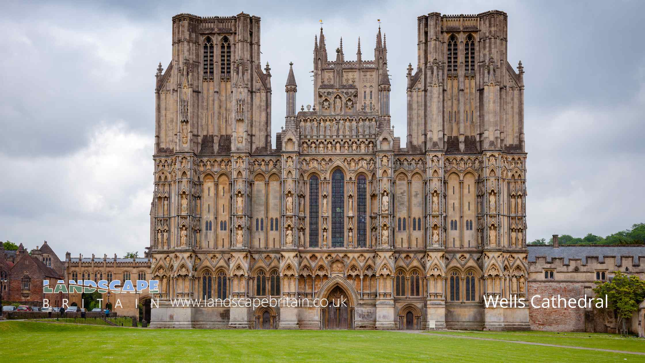
Wells’ Cathedral Church of St Andrew, prominently recognised as a Grade I listed monument, stands as an enduring testament to both the spiritual and architectural heritage of the region. It stands as an epitome of craftsmanship, meticulously crafted over the years, drawing the attention of historians, artists, and tourists alike.
Designated as a Grade I listed building, the Cathedral’s significance is accentuated by its intricate stone carvings that adorn its façade and interiors. These meticulously detailed carvings offer a glimpse into the artistic sensibilities of the artisans of yesteryears and are representative of the specific period in which they were crafted.
Each corner of the Cathedral, from its majestic spires to its imposing entrance, bears hallmarks of the standards that warrant its Grade I listing. The ancient glasswork that embellishes its windows provides a kaleidoscope of colors, reflecting the artistic genius and intricate craftsmanship that went into its creation. The intricate designs, which have withstood the ravages of time, are irreplaceable treasures that showcase the immense value and unparalleled artistry of the era.
Moreover, the Cathedral’s grand organ, believed to have been crafted during the Victorian era, stands as a testament to the acoustic marvels of its time. The sounds emanating from this grand instrument encapsulate the essence of a bygone era, reminding visitors of the musical brilliance of past centuries.
Visitors are also taken on a journey through time when they encounter the augmented reality experience offered by strategically placed QR codes within the Cathedral. These digital markers delve deep into the Cathedral’s storied past, its significance in the Grade I listing, and its invaluable contributions to the region’s cultural and architectural heritage.
The Cathedral, with its Grade I listed status, is more than just a religious edifice. It’s a living testament to a rich tapestry of art, history, and architecture, that continues to inspire awe and admiration in every onlooker.
Wells Cathedral is in Mendip Hills AONB, a designated Area of Outstanding Natural Beauty.
Created: 11 August 2023 Edited: 29 November 2023
Wells Cathedral Information
Wells Cathedral Address
Cathedral Green, Wells BA5 2UE, UK
BA5 2UE
Website: http://www.wellscathedral.org.uk/
Get directionsLocal History around Wells Cathedral
There are some historic monuments around including:
Bowl barrow 300m north east of Whitnell CornerTwo bowl barrows 550m south west of Haydon HouseSavory's HoleBowl barrow 650m northeast of Higher Pitts FarmBishop's tithe barnRoman building 270m north east of Priddy churchBowl barrow in the garden of BeechbarrowBowl barrow 230m north west of Hunter's Lodge InnBowl barrow 500m north of East WaterBowl barrow 700m south of Bristol Plain Farm: part of a linear round barrow cemeteryFour round barrows SE of Miners' Arms Inn, Chewton Rabbit WarrenRhinoceros Hole, WookeyBowl barrow 750m southwest of Dale FarmBowl barrow 570m south east of Lodmore FarmBowl barrow 350m northeast of Cheddar Head FarmBowl barrow 90m northeast of Hill ViewDisc barrow 610m northeast of Drove CottagePriddy Circle and barrow cemetery 400m north of Castle of Comfort InnBowl barrow 430m north of Whitnell CornerBowl barrow 770m south of Townsend FarmThree of the Priddy Circles and one barrow, 400m west of Castle FarmBowl barrow 490m north west of Pen Hill FarmBowl barrow 300m southwest of Moor ViewBowl barrow 400m south of RookhamBowl barrow 380m south east of BeechbarrowBowl barrow 570m south east of Southfield FarmBowl barrow 380m south east of Southfield FarmBowl barrow 550m south east of Southfield FarmThree bowl barrows 400m north west of Haydon HutBowl barrow 730m southeast of Bristol Plain FarmBowl barrow 760m southeast of Bristol Plain FarmBowl barrow 850m south of Bristol Plain Farm: part of a linear round barrow cemeteryBowl barrow 450m south-east of Red Quar FarmBowl barrow 820m south of Bristol Plain Farm: part of a linear round barrow cemeteryBishop's Palace ruined portions, walls and well housePair of bowl barrows 405m east of East Water Drove (Part of Priddy Nine Barrows Cemetery)Bowl barrow 410m northeast of Bristol Plain FarmBowl barrow 300m west of Newlands FarmRowberrow: a bowl barrow 40m north of Hill ViewBowl barrow 450m east of Bristol Plain FarmHenge 370m north east of Drove CottageBowl barrow on Stock Hill: part of the Stock Hill round barrow cemeteryPair of bowl barrows 350m NNE of Whitnell CornerLong barrow 370m south-south-east of Castle FarmThree bowl barrows in Big Plantation, 690m south west of BeechbarrowFenny Castle: a motte and bailey castleBowl barrow on Stock Hill: part of the Stock Hill round barrow cemeteryBowl barrow 70m west of Rowberrow FarmFive bowl barrows 500m north west of Cuckoo Cleeves: part of the Stock Hill round barrow cemeteryBowl barrow, 455m west of Brimble Pit PoolBowl barrow 150m north east of Victoria FarmTwo round barrows 600yds (550m) ENE of Green OreBowl barrow 420m east of Bristol Plain FarmTwo bowl barrows 350m south of Brimble Pit Pool: part of a group of round barrows north and east of Foxhills WoodBowl barrow 350m north west of Harptree LodgeThe Abbey Barn at Abbey FarmBowl barrow 850m southeast of Bristol Plain FarmBowl barrow 310m southeast of Eastwater FarmRound barrows SW of Cleeve's PlantationLong barrow 600m east north east of Brimble Pit PoolBowl barrow 400m southwest of Moor ViewBrowne's GateLong barrow, round barrow and cairn on Pen HillBowl barrow 170m south-east of Hunter's Lodge InnBowl barrow 70m northwest of Hill ViewBadger Hole, WookeyBowl barrow 570m west of Newlands FarmBracelet CaveLong barrow and bowl barrow 430m north west of the Mendip Nature Research StationBowl barrow 600m east of Priddy Hill FarmRound barrow 1435m SE of Miners' Arms InnSt Cuthbert's and Chewton lead mines and Fair Lady WellPriddy Glebe Barrow: a bowl barrow 25m north of St. Lawrence's ChurchBowl barrow 120m north west of Burnt WoodBowl barrow 870m southwest of Dale FarmBowl barrow 450m north west of Harptree LodgeTwo round barrows SE of Castle of Comfort InnSt Michael's Church, monastic remains, and other settlement remains on Glastonbury TorBowl barrow 810m southeast of Bristol Plain FarmBowl barrow 850m south of Townsend FarmBowl barrow 550m south east of Brimble Pit Pool: one of a group of round barrows north and east of Foxhills WoodOutlook CaveFenny Castle Cross: a medieval wayside cross 20m north west of Castle Farm, CastleBowl barrow 300m south west of Harptree LodgeTithe barnRound barrow cemetery 470m and 400m north of Pen Hill FarmDeserted medieval farmstead and field system NW of Ebbor WoodBowl barrow 130m west of St Lawrence's ChurchBowl barrow 250m north west of Victoria FarmLinear barrow cemetery comprising six bowl barrows 510m south west of Townsend FarmKing's Castle enclosures, Iron Age defended settlementMedieval standing cross 80m south of St Mary's ChurchBowl barrow 390m northeast of Bristol Plain FarmBowl barrow 435m north west of Ivy CottageBowl barrow 800m south of Townsend FarmStow Barrow : a bowl barrow 700m southwest of Haydon Grange FarmBishop's palaceGroup of round barrows 750m north west of Ivy CottageBowl barrow 600m north of Rookham PlantationBowl barrow 520m south-east of Red Quar FarmThree bowl barrows at Green Ore, two 150m south east and one 420m south west of Newlands FarmGroup of seven round barrows 380m east of East Water Drove (Part of Priddy Nine Barrows Cemetery)Ashen Hill barrow cemetery: a group of eight round barrows 500m southeast of Harptree LodgeBarrow, 350m east of Harptree LodgeBowl barrow 470m south east of Southfield FarmTwo bowl barrows 850m south east of Brimble Pit Pool: part of a group of round barrows north and east of Foxhills Wood.


