Rievaulx Abbey by Hannah Blundell
Rievaulx Abbey
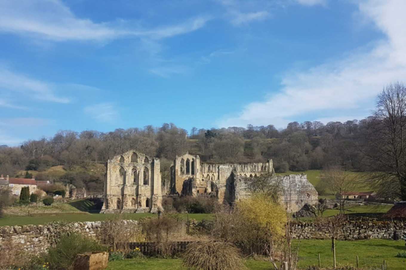
Rievaulx Abbey is in The North York Moors National Park in England.
Rievaulx Abbey is situated in Ryedale, on the east bank of the River Rye and comprises two separate areas containing the standing remains and inner precinct of the Cistercian monastery and an outer precinct.
The well-preserved standing remains of Rievaulx Abbey demonstrate the usual layout of a Cistercian monastery but, not in the standard orientation. Traditionally, monastic buildings were laid out so that the church ran east to west and formed the north range of a four-sided complex known as the cloister. Domestic buildings such as kitchens would then form the south range. Buildings such as the parlour, chapterhouse and Abbot’s lodging would form the east range, and the lay-brother’s quarters the west.
However, at Rievaulx, the lay of the land was such that the church was built almost on a north-south axis and formed what amounted to the east range. Old documents describe the complex as if it adhered to the traditional plan.
The earliest standing remains at Rievaulx are those of the nave and transepts of the church, and parts of the chapterhouse and frater (refectory). The former date to just after the foundation of the abbey and were built between 1140 and 1150.
The east end of the church and the choir, that is the stalls between the east end and the nave where the monks sang the offices, were rebuilt and extended in the thirteenth century. Rather than demonstrating the architectural simplicity usually observed by the Cistercians - and seen in the earlier parts of the church - the later parts are a very fine example of English Gothic architecture.
Flying buttresses were added in the fourteenth century to support the vault above the choir, and in the same century a sacristy, a room for storing sacred vessels, was built in the angle of the choir and south transept.
South of the south transept were the library, vestry and chapterhouse. The remains of the chapterhouse are those of a rectangular room with a semicircular end or apse, lined with an arcade inside which the monks sat. A number of graves inside the chapterhouse indicate that it was the burial place of the early abbots.
In the thirteenth century a shrine marked by two inscriptions to have been dedicated to William, the first abbot was added.
East of the chapterhouse lay the infirmary, built in the late twelfth century and partly remodelled in sixteenth to form the later abbots’ lodging. Together with a thirteenth century chapel, fourteenth century infirmary buildings and the fifteenth century abbot’s kitchen. This enclosed a small court on its east side and also formed the east range of the infirmary cloister.
Other late twelfth century buildings enclosed the infirmary cloister, including the so-called Long House, a day room with the monks’ dorter (dormitory) over, and the reredorter or latrine with its drain running underneath.
A passage went from the covered walk on the north side, between the treasury and day room, and joined the infirmary cloister to the main cloister. This featured an arcade of round-headed arches on double shafts which dated to the third quarter of the twelfth century.
The west range of the cloister was formed by the late twelfth century lay-brothers’ quarters and an outer parlour remodeled in the fourteenth century. A complex of domestic buildings made up the south range and included a warming house with two fireplaces, an early kitchen, and the frater (refectory) with an attached lavatorium where the monks washed their hands before meals.
A separate building, originally thought to have been a guesthouse with its own oratory or private chapel, lay below the angle of the south and east cloister ranges and has been identified as a fulling mill.
Created: 4 July 2021 Edited: 29 November 2023
Rievaulx Terrace Information
Rievaulx Terrace Address
Rievaulx, Helmsley YO62 5LJ, UK
YO62 5LJ
Website: http://www.nationaltrust.org.uk/rievaulx-terrace/
Get directionsRievaulx Abbey LiDAR Map

Contains public sector information licensed under the Open Government Licence v3.0
Local History around Rievaulx Abbey
There are some historic monuments around including:
Old Byland monastic grange immediately to the west and north-west of Valley View FarmRound barrow on Sproxton Moor, 410m north of Tom Smith's CrossRievaulx Abbey Cistercian monastery: inner and outer precinct, water-management works, agricultural features, enclosures and ancillary buildingsLong Grain round barrowsHelmsley BridgeMedieval lordly residence immediately west of Church FarmRound barrow on Scawton Moor, 700m ENE of High LodgeRound barrow, 50m south of Sour Leys FarmRound barrow 780m NNE of Waterloo Farm, the easternmost of three round barrows in Far Moor PlantationGriff medieval settlement and Cistercian monastic grange, 400m west of Griff FarmCairnfield 500m north east of Bumper CastleMonastic grange belonging to Rievaulx Abbey at Laskill FarmNewlass Cistercian monastic grange adjacent to New Leys FarmRound barrow 750m NNW of Potter HouseDyke at the north eastern end of Stone Bridge Howl, 760m north west of Court House FarmRound barrow 600m west of Grange FarmWayside cross base on south side of the churchyard wall at ScawtonLinear dyke known as Double Dikes, in Waterloo PlantationRound barrow 810m NNE of Waterloo Farm, the northernmost of three round barrows in Far Moor PlantationRound barrow 625m north of Moor GateStudford RingSquare barrow on Scawton Moor, adjacent to the quarry between Snip Gill Slack and Sword Rigg SlackDropping Gill round cairnsByland Abbey Cistercian monastery: monastic precinct, water-management earthworks, enclosures, ancillary buildings and quarriesGriff Cross, wayside cross 800m NNE of Griff Farm on the road from Helmsley to RievaulxHelmsley Castle: twelfth century ringwork, twelfth to fourteenth century enclosure castle and sixteenth century mansionRound barrow on Scawton Moor, 390m north east of High LodgeLinear boundary earthwork 370m east of Oscar Park FarmDouble dykes on Painter RiggPry Rigg round barrowsRound barrow on Scawton Moor, 620m north west of High LodgeRoppa South Cross on Carr Cote Ridge 1100m WSW of PiethornRound barrow on Scawton Moor, 480m north east of High LodgeByland Moor round cairnsRound barrow 710m NNE of Waterloo Farm, the southernmost of three round barrows in Far Moor Plantation.


