Odin Mine by JRL
Odin Mine
Odin Mine is in The Peak District National Park in England.
Odin Mine is a historic lead mine located near Castleton in Derbyshire, within the Peak District National Park. It is considered one of the oldest documented lead mines in England, with written records dating back to 1280. The name “Odin” is believed to reference the Norse god, suggesting that Viking settlers may have influenced the naming of the site.
The mine was most active between the 17th and 19th centuries, with peak production occurring between the 1720s and 1800. At its height, Odin Mine employed around 100 people, including men, women, and children, and produced as much as 800 tons of lead ore per year. The workings stretched for more than 1.5 kilometres into the hillside beneath Mam Tor, forming an extensive network of tunnels, shafts, and levels. Lead mining ceased in 1869, though smaller-scale extraction of minerals such as fluorspar and barite continued into the early 20th century.
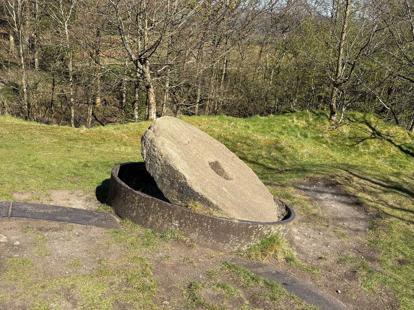
Today, Odin Mine is a Scheduled Ancient Monument managed by the National Trust. While the underground sections are closed to the public for safety reasons, the surface remains can be explored via a footpath from the old Mam Tor road. Visitors can see features such as a limestone gorge, which was used for early open-cast mining, and a large gritstone crushing wheel dating from 1823, used to process the lead ore. Odin Cave, a small natural cavern at the site, is also accessible.
The area around the mine supports unique plant life, including metallophyte species that thrive on the heavy-metal-rich spoil heaps. Odin Mine is a popular stop for walkers heading towards Mam Tor and offers insight into the long history of lead mining in the Peak District. It combines industrial heritage with striking natural scenery and is an important reminder of the region’s mining past.
Created: 18 April 2025 Edited: 18 April 2025


Odin Mine
Odin Mine LiDAR Map

Contains public sector information licensed under the Open Government Licence v3.0
Local History around Odin Mine
There are some historic monuments around including:
Harrod Low long barrowPlatform cairn south of Hill RakeTown defences 270m north and 350m north east of Peveril CastleEldon Hill crushing circle, associated lead mining remains and palisaded enclosure on Eldon HillCrookstone Hill round cairnMedieval hospital 530m south east of Losehill HallSnelslow Plantation bowl barrowRound cairn on Bridge-end Pasture, 300m north-east of Two Thorne Fields FarmStanding cross in the churchyard of St Peter's ChurchPeveril Castle eleventh to fourteenth century tower keep castleBowl barrow on Withery LowWayside cross known as Eccles CrossBatham Gate, Roman roadOx Low oval barrowFaucet Rake lead mines 870m south west and 930m south east of Oxlow HousePeakshill or Oden soughRound barrow 500m south west of Peveril CastlePalisaded hilltop enclosure 230m SSE of Dirt LowEldon Hill bowl barrowLord's Seat bowl barrowGautries RakeGautries Hill bowl barrowSlitherstone and Linacre lead mines and a limekiln 725m south west of Rowter FarmHigh Rake MineCop Rake and Moss Rake lead mines 750m north east of Wheston HouseWatt's Grove Rake lead mines 520m north of SweetknollBowl barrow on Withery LowHill's Venture lead mineAnglian high cross in the churchyard of St Peter's ChurchOdin Mine nucleated lead mine and ore works, 350m WNW of Knowlegates FarmRound cairn and clearance cairn 770m north west of Crookhill FarmSlight univallate hillfort and two bowl barrows on Mam TorTides Low bowl barrow, limekiln and standing stonePerry Dale bowl barrow and long barrowCop Low oval barrowTideslow Rake lead rake and lime kilnRound cairn on Bridge-end Pasture, 600m north-east of Two Thorne Fields FarmThe Folly platform cairnNew Rake lead mines 600m south east of Rowter FarmOxlow Rake lead minesCoalpithole RakeStanding cross known as Wheston CrossHope MotteEngine Sough and associated nucleated lead mine, 500m south of Mam TorHow Grove Lead MineThe Tong bowl barrow and long barrowPin Dale lead side veins.


