Gib Hill Oval Barrow and Bowl Barrow by munki-boy
Gib Hill Oval Barrow and Bowl Barrow
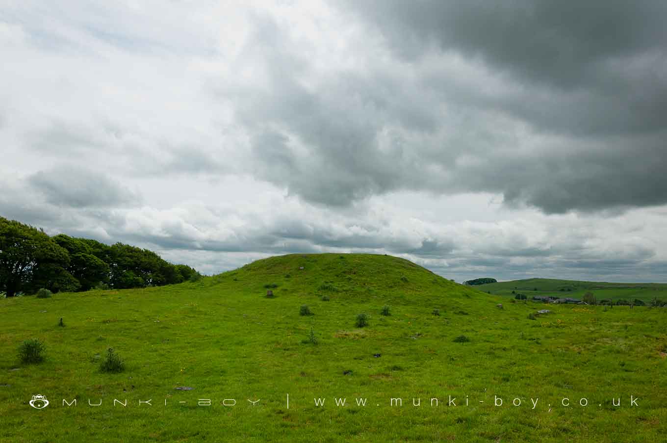
Gib Hill Oval Barrow: A Portal to Neolithic and Bronze Age Rituals
Introduction to Gib Hill Oval Barrow Gib Hill, located a mere 200 meters southwest of the renowned Arbor Low henge in Derbyshire, is a remarkable prehistoric site. It consists of an oval barrow, a type of funerary and ceremonial monument from the Early to Middle Neolithic periods, overlaid by a large bowl barrow from the Late Neolithic to Late Bronze Age. This layered structure serves as a physical timeline, revealing the evolving burial practices and ritualistic activities of ancient Britain.
Oval Barrow: A Neolithic Monument The oval barrow at Gib Hill is a notable example of Neolithic earthworks. Characterized by its elliptical shape, it measures 27m by 46m and stands 2 meters high. The barrow’s orientation towards Arbor Low henge suggests a deliberate alignment, possibly indicating a broader ritual landscape. Typically, oval barrows were used for communal burials or individual interments beneath the mound, reflecting the burial customs of Britain’s early farming communities.
Archaeological Significance Gib Hill’s oval barrow is particularly significant for its well-preserved state and the archaeological evidence it has yielded. Excavations have revealed underlying small barrow cemeteries predating the oval mound, indicating its importance as a ritual site over an extended period. The surrounding construction ditches, believed to be intact, potentially hold further archaeological insights.
The Bowl Barrow: A Later Overlay Superimposed on the south-west end of the oval barrow is a large bowl barrow, a more common type of funerary monument dating from the Late Neolithic to the Late Bronze Age. This mound, roughly 24m by 27m in diameter and about 3 meters high, showcases the diversity in burial practices and beliefs of early prehistoric communities.
Discoveries and Excavations Gib Hill has been subject to several partial excavations, notably by William Bateman and Samuel Mitchell in 1824, and Thomas Bateman in 1848. Findings include a smaller mound beneath the oval barrow with charcoal and cremated human remains, flint artifacts, and an iron brooch, indicating the later re-use of the barrow possibly in Roman or Anglian periods. Thomas Bateman’s findings of clay mounds with charcoal, wood, and ox bones under the oval barrow, and a square cist with a cremation and pottery vessel under the bowl barrow, further highlight the site’s extensive use over different eras.
State Protection and Heritage Value Like Arbor Low, Gib Hill has been under State care since 1884, underscoring its national importance. As a rare oval barrow overlaid by a bowl barrow, it provides invaluable insights into the funerary rites, social organization, and ritual practices of Neolithic and Bronze Age communities.
Gib Hill’s complex archaeological layers make it an integral part of the rich prehistoric landscape surrounding Arbor Low. The site’s preservation allows for ongoing exploration into the depths of Britain’s early farming societies, making it an invaluable resource for understanding the deep-rooted traditions and customs of our ancestors.
Created: 30 December 2023 Edited: 26 March 2024
Gib Hill Oval Barrow and Bowl Barrow
Gib Hill Oval Barrow and Bowl Barrow LiDAR Map

Contains public sector information licensed under the Open Government Licence v3.0
Local History around Gib Hill Oval Barrow and Bowl Barrow
There are some historic monuments around including:
Bowl barrow at south-eastern end of summit of Gratton HillBrundcliffe hlaewFin Cop promontory fort, bowl barrow and eighteenth century lime kiln with associated quarryBowl barrow in Foggy Lees PlantationKenslow Knoll bowl barrowBurton Moor bowl barrowFriden Hollow bowl barrowRomano-British settlement and field system immediately north west of Roystone GrangeAleck Low bowl barrowBowl barrow on Wetton Hill 650m north-west of Under WettonMoneystones bowl barrow southMagpie, Dirty Red Soil, Maypit, Horsesteps and Great Red Soil lead mines and a limekiln, 590m south east of Johnson Lane FarmLarks Low bowl barrowArbor Low henge, large irregular stone circle, linear bank and bowl barrow'Sheepwash' BridgeLathkill Dale and Mandale mines and soughsHawks Low bowl barrowBowl barrow at north-west end of summit of Gratton HillWolfscote Hill bowl barrowLean Low bowl barrowBorther Low bowl barrowVincent Knoll bowl barrowBowl barrow north of Manor HousePilsbury Castle Hills motte and bailey castleBee Low bowl barrowBole Hill bowl barrowAshford BridgeTwo bowl barrows at PilsburyLiffs Low bowl barrowSmerrill Barn bowl barrowCalling Low bowl barrowBowl barrow at north-west end of Gratton HillFive Wells chambered tombBenty Grange hlaewThe Fishing House of Charles Cotton, Beresford DaleMedieval grange and field system, 200m south of Royston GrangeMeadow Place bowl barrowDimin Dale Romano-British settlement and field system, south of Taddington WoodGrindlow bowl barrowSmerrill Moor bowl barrowTrue Blue nucleated lead mine, 600m ESE of Magpie MineEnd Low bowl barrowMedieval settlement on the north western slopes of Cales Dale, 490m north west of Cales FarmMedieval settlement immediately south east of Smerrill GrangeBrushfield Hough bowl barrowLong Dale bowl barrowPrehistoric and Romano-British barrow and medieval animal pen, 450m south east of Roystone GrangeCronkston Low bowl barrowParsley Hay bowl barrowNettly Knowe bowl barrowRoystone Grange bowl barrowRomano-British settlement and field system, 600m south of Roystone GrangeMouldridge Grange, earthworks immediately south of Mouldrige Grange FarmRingham Low bowl barrowRomano-British field wall and embankment, 200m south west of Roystone GrangeBowl barrow east of Arbor LowRomano-British field system, 420m south east of Roystone GrangeBowl barrow on Narrowdale HillTwo bowl barrows on Chelmorton LowPea Low bowl barrowGib Hill oval barrow and bowl barrowBowl barrow west of Manor HouseMoneystones bowl barrow north.


