Former Congregationalist Church at Worcester by Auto Locksmith
Former Congregationalist Church at Worcester
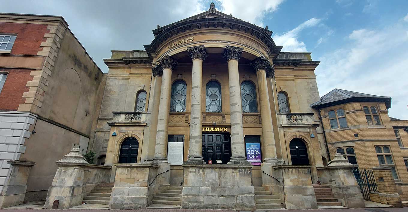
A grade II listed former Congregationalist church, built in 1858 and converted to a nightclub in the 1980s.
Probably built by Architects Poulton and Woodman from Cotswold stone ashlar over brick with pinkish-red brick to the rear. The building features a pyramidal slate roof with finial and right stack with cornice and pots.
Contstructed on a rectangular on plan with apse, in the Classical style, the church has a single tall storey, described to front facade as two storeys, and three bays with outer wings.
The facade is stepped twice with central break forward, central bowed tetrastyle Corinthian portico with Doric pilasters to responds, surmounted by pediment with acroteria. Columns stand on a tall plinth interrupted by a flight of horseshoe steps to a central entrance. The entrance has a twelve-panel double doors with a panelled overlight in Caernarvon-arched surround with cornice on scrolled corbel brackets. A continuous band over with panels with lozenge motif below round-arched windows with circular glazing bars, with imposts, architraves and keystones.
The outer bays feature large piers with pyramidal caps on to the street frontage and flights of steps to six-panel doors with blind fanlights in tooled architraves with keystone, pulvinated frieze and cornice surmounted by balustrade with bulbous balusters. The upper stage has round-arched windows with imposts, architraves and keystones. The wings have Caernarvon-arched openings, the left with a 4-panel door, and the right has a replacement door with panels over. A continuous cornice with acanthus modillions, parapet with cornice.
Created: 11 June 2021 Edited: 29 November 2023
Former Congregationalist Church at Worcester
Local History around Former Congregationalist Church at Worcester
There are some historic monuments around including:
Worcester city centrePowick BridgeDovecote at Hawford GrangeEdgar Tower entrance to the Cathedral CloseCivil War fieldwork at Tamar Close, WorcesterCity walls: section S of The Butts, extending 150ft (50m) between Angel Place and Bath CottageCity walls: section extending 85ft (30m) along W side of Talbot StreetSt Alban's ChurchCity walls: section extending 90ft (30m) under the E walls of Nos 2-5, No 1 Court, New StreetRemains of Guesten HallWestern range of monastic buildings of the Cathedral PrioryChurchyard cross in St Mary the Virgin's churchyardDisc barrow 400m SSE of Common FarmCity walls: section extending 130ft (40m) from the back of No 27 New Street to Windsor RowEnclosure W of Church FarmHawford Roman campEnclosure 110yds (100m) N of St Bartholomew's ChurchDisc barrow 400m south of Common FarmMedieval fishponds and ridged cultivation remains, east of Grimley villageCity walls: section S of The Butts, extending 100ft (30m) E from Rack AlleyCity walls: section extending 130ft (40m) between Charles Street and Portland PlaceFort RoyalCity walls: section extending 50ft (15m) between Windsor Row and Nash's PassageMotte castle, moated site, and medieval agricultural remains at Crookbarrow FarmDisc barrow 500m south of Common FarmCity walls: section extending 280ft (90m) W and SW of Clare StreetRefectory of St Mary's Priory in Cathedral CloseGrimley churchyard crossMoated monastic grange and fishpond complex at Middle Battenhall Farm, 450m north of Upper Battenhall FarmMoated site at Earl's Court.


