Cloughton
Cloughton
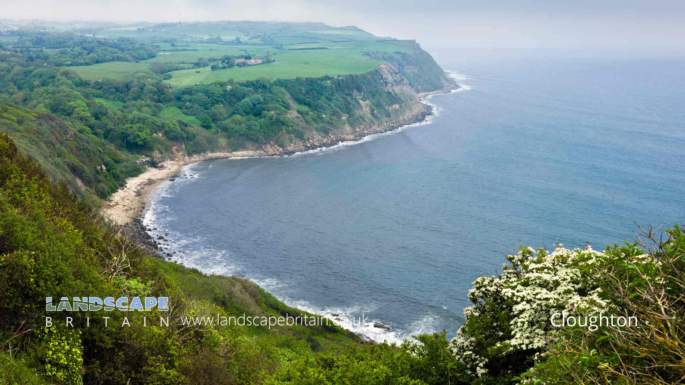
Cloughton is a small village located in the Scarborough district of North Yorkshire, England. Nestled within the stunning landscapes of the North York Moors National Park, it presents a perfect blend of history, natural beauty, and tranquility.
The history of Cloughton can be traced back to the Domesday Book of 1086, where it was mentioned as “Clactune.” Over the centuries, the village has retained much of its traditional charm. It’s characterized by picturesque stone cottages, a historic church, and beautifully maintained gardens that add to its rustic allure.
One of the key landmarks in Cloughton is St. Mary’s Church, an Anglican church that stands as a testament to the village’s historical roots. This church, with its ancient architecture, not only serves the spiritual needs of the community but also attracts history enthusiasts and visitors interested in ecclesiastical architecture.
The surrounding countryside offers an array of outdoor activities. Walking trails meander through the moors, providing opportunities for hiking, bird watching, and nature photography. The nearby North Sea coast, just a short distance away, adds another dimension to Cloughton’s appeal. Here, visitors can enjoy the rugged coastline, with its cliffs and beaches, which are ideal for coastal walks and seaside excursions.
In terms of amenities, Cloughton maintains a quaint village atmosphere. It has a few local pubs and eateries, offering a taste of traditional Yorkshire hospitality and cuisine. These establishments are not just places to dine but are social hubs where locals and visitors alike can mingle in a friendly environment.
Cloughton also serves as a gateway to explore the broader attractions of North Yorkshire. Its proximity to Scarborough means that visitors can easily access the larger town’s facilities and attractions, such as the historic Scarborough Castle, the bustling seafront, and the Stephen Joseph Theatre, known for its association with the playwright Alan Ayckbourn.
Overall, Cloughton is a charming village that offers a peaceful retreat in the heart of North Yorkshire. Its blend of history, natural beauty, and close-knit community makes it a delightful destination for those seeking a quieter, more authentic experience of English village life.
Created: 7 January 2024 Edited: 26 March 2024
Cloughton
Local History around Cloughton
There are some historic monuments around including:
Round barrow 730m north west of Three Lords' StonesSquare barrow in Broxa Forest, 285m west of Swarth HoweRound barrow 300m south west of Church Road FarmRound barrow 200m north of Keepers CottageRound barrow 150m south of Thirley Beck FarmRound barrow 20m west of Beacon FarmRuins and below ground remains of St Mary's medieval churchMedieval dyke known as Green DikeCup and ring marked rock 570m south west of Brickyard CottageSquare barrow in Broxa Forest, 580m south east of WhisperdalesRound barrow 1200m NW of Beacon FarmRound barrow 520m north west of Keepers CottageTwo segments of a prehistoric linear boundary 530m north and 200m north east of Beacon FarmRound barrow in Hodgson Moor Plantation, 510m north east of Linglands FarmRound cairn on Inn Moor, 290m south west of Beacon FarmMedieval dyke known as War DikeRound barrow 190m west of Moorland HouseRound barrow in Raincliffe Woods, 420m north of Osborne LodgeTwo round barrows known as Beacon Howes, 250m south of FairviewBowl barrow 300m north east of Beacon FarmSmall stone circle on Standingstones Rigg, 720m north west of Linglands FarmRound barrow on Surgate Brow 290m west of Surgate Brow FarmRound barrow 120m west of Kirkless FarmRound barrow known as one of the Three Howes, 780m WNW of Teydale FarmCup and ring marked rock 630m south west of Brickyard CottageThe Thieves' Dikes: prehistoric linear boundaries and associated featuresRound barrow 1350m NW of Beacon FarmCross dyke in Cloughton Plantations, 550m and 890m north east of Gowland FarmSquare barrow in Broxa Forest, 720m south west of Surgate Brow FarmRound barrow known as Burnt HowePost-medieval dovecote 40m south of Cloughton HallRound cairn in Harwood Dale Forest, 540m south west of Teydale FarmRound barrow on Flockrake Noddle, 550m SSW of Silpho Brow FarmRound barrow 485m south west of Stoupe Brow FarmRound barrow 370m south east of Rudda CottagesCup and ring marked rock 620m south west of Brickyard CottageRound cairn on Cowgate Rigg, 790m south west of Teydale FarmRound barrow 100m north of Church Road FarmRound barrow in Cloughton Plantations, 740m north west of The HulleysRound barrow 200m south west of Church Road FarmRound barrow on Surgate Brow known as Swarth HoweRound barrow beside Lady Grace's RideRound barrow known as Hunter HoweRound barrow 360m north east of Brooklands FarmRound barrow on Reasty Hill Top 820m south east of BreckenhurstRound barrow known as one of the Three Howes, 890m WNW of Teydale FarmRound cairn on Cowgate Rigg, 925m north east of Moor Cottage FarmRound barrow 920m south west of Silpho Brow FarmRound barrow on Coverdale Moor, 470m south of North Stile CottageRound barrow on Silpho Brow, 740m west of Silpho Brow FarmSquare barrow in Broxa Forest, 440m south of Swarth HoweRound barrow on Pye Rigg End known as Pye Rigg HoweCairnfield on Standingstones Rigg, including a cup and ring marked rock 780m and 800m north west of Linglands FarmFour round barrows 520m west of Brickyard CottageSkell Dikes: a prehistoric linear boundary with two associated round barrows and an adjoining pit alignmentRound barrow on Suffield Moor, 750m south of Silpho Brow FarmStone hut circle and iron working site on Holm Slack, 300m south of The HulleysTwo round barrows known as Rudda Howes, 400m north west of Rudda FarmRound barrow 30m north east of Old Mill HouseThree barrows at Seamer Beacon and the ruins of Baron Albert's TowerRound barrow known as one of the Three Howes, 820m WNW of Teydale FarmRound barrow 160m north of Beacon FarmThree round barrows 620m WSW of Brickyard CottageRound barrow 60m west of Beacon FarmRound barrow on Inn Moor, 390m west of Beacon FarmRound barrow 360m west of Tofta FarmWorld War II Radar station 600m east of Bent Rigg FarmRound cairn on Suffield Moor, 540m north west of Beacon FarmBowl barrow 1300m north of Betton FarmHagworm Hill round barrowScarborough Castle: Iron Age settlement, Roman signal station, Anglo-Scandinavian settlement and chapel, C12 enclosure castle and C18 batteryRound barrow 1100m NW of Beacon FarmRound barrow on Reasty Hill Top 840m south east of BreckenhurstRound cairn on Cowgate Rigg, 870m north of Brooklands FarmTwo linear earthworks on Row Brow which extend into Raincliffe WoodsCup and ring marked rock 590m south west of Brickyard CottageRound cairn on Pye Rigg 600m SSE of Pye Rigg HoweRound barrow on Coverdale Moor, 530m south of North Stile CottageRound barrow cemetery 440m west of Brickyard CottageRound barrow 680m north west of Three Lords' StonesCairnfield 540m north west of Linglands FarmCup and ring marked rock 615m south west of Brickyard Cottage.


