Tytherington
Tytherington is a Village in the county of Wiltshire.
Tytherington postcode: BA12 7DX
There are great places to visit near Tytherington including some great historic monuments, ancient sites, historic buildings, country parks, lakes and villages.
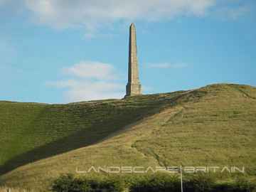
Tytherington has some unmissable historic monuments nearby like Lansdowne Monument, Cherhill White Horse, and Avebury.
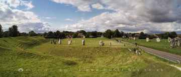
Avebury, West Kennet Long Barrow, The Sanctuary, and Silbury Hill are some of Tytherington best ancient sites to visit near Tytherington.
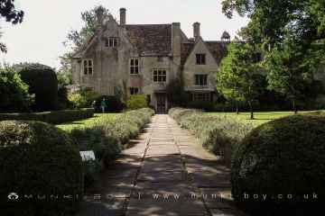
Places near Tytherington feature a number of interesting historic buildings including Avebury Manor.
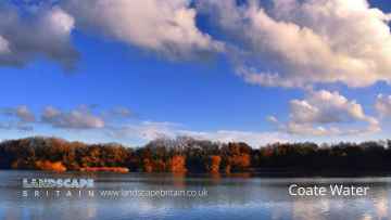
The area close to Tytherington boasts some of the best country parks including Coate Water Country Park.
Don't miss Coate Water's lakes if visiting the area around Tytherington.
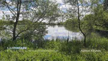
Tytherington is near some unmissable villages like Ashton Keynes,
Tytherington History
There are some historic monuments around Tytherington:
- Long barrow 300m north-east of Albany Place
- Bowl barrow 300m east of Boyton Field Barn
- Bowl barrow 200m south-west of Keysley Farm
- Bowl barrow on the summit of Cop Heap
- Lock up 20m south of Little London Cottage in the High Street
- Earthwork enclosure in Penning Wood, 290m NE of Penning
- Enclosure and linear earthworks between Bishopstrow Down and South Down Sleight
- Cross ridge dyke on Warminster Down
- Bell barrow on Parsonage Down, 1.3km south east of Lord's Hill Farm
- Bowl barrow: one of three round barrows on Four Hundred Down
- Knook Castle hillfort and associated prehistoric and Romano-British landscape
- Bowl barrow north of White Horse Farm
- Round barrow east of South Down Sleight
- Bowl barrow: one of two round barrows south-east of Tinhead Hill Farm
- Rabbit warren 580m and 660m south east of Fitzroy Farm
- Codford Circle hilltop enclosure
- Enclosure south-east of White Horse Farm
- Two cross ridge dykes 710m and 790m east of Wellhead Farm
- Bowl barrow 700m south-west of Keysley Farm
- Part of a prehistoric field system on Codford Down
- Linear earthwork on Knook Down
- Boundary feature 700m south-west of The Plantation, West Lavington Down
- Linear boundary on Bidcombe Down and Whitepits Down
- Three bowl barrows north of South Down Sleight
- Pillow mound on Knook Down
- Bowl barrow 540m north of Woodbine Barn
- Middle Hill round barrow
- Bowl barrow on Arn Hill Down, 450m east of New Farm
- Bowl Barrow: one of a dispersed group of five barrows adjacent to the Imber-Warminster track
- Long barrow on Cold Kitchen Hill
- Bowl barrow: one of three round barrows on Thirteen Hundred Down
- King Barrow: a long barrow 100m north of Bishopstrow House
- Rough Barrow, round barrow, south of Sealland Cross
- Bowl barrow 500m south-east of Eastleigh Court
- Bowl barrow on Keysley Down, 250m west of the A350 Warminster-Shaftesbury Road
- Bowl barrow: one of three round barrows on Thirteen Hundred Down
- Romano-British village N of Stockton Wood
- Round barrow south-west of Knook Barrow, long barrow
- Bowl barrow 880m north east of Field Barn Farm
- Bowl barrow 1110m south east of St Michael's Church
- Bowl barrow west of Breakheart Bottom
- Battlesbury Camp Monuments: hillfort, settlement, cemetery, barrows, enclosure, and field systems
- Bowl barrow north of Dirtley Wood
- Bowl barrow: one of a group of dispersed barrows south-east of Norton Plantation
- Bowl barrow 560m north east of Lord's Hill Farm
- Earthwork enclosure in Great Ridge wood, 350m north east of Point Pond
- Cross dyke 870m north west of Burton Farm
- Bowl barrow in High Park on south facing slope of Fonthill Down
- Iron Age settlement on Cow Down, 990m north west of Haycombe Hill Farm
- Bowl barrow 500m south of Upton Scudamore
- Bowl barrow: one of three round barrows on Four Hundred Down
- Section of Roman road on Pertwood Down
- Bowl Barrow: one of a group of dispersed barrows south-east of Norton Plantation
- Bowl barrow: one of a group of dispersed barrows south-east of Norton Plantation
- Two round barrows in Chaddenwick Furze
- Knook barrow, long barrow
- Scratchbury Hill Monuments: Iron age hillfort, round barrows and enclosures
- Colloway Clump long barrow
- Strip lynchets south of Westdown Farm
- Bell barrow on Rook Hill, 200m west of Pertwood Wood
- Two of a dispersed group of five barrows adjacent to the Imber-Warminster track
- Bowl barrow: one of two round barrows south-east of Tinhead Hill Farm
- Middlehill settlement and associated cultivation earthworks.
- Robin Hood's Bower earthwork enclosure in Southleigh Wood
- Bowl barrow 850m north west of Lower Pertwood Farm
- Combe lynchet system on Oxendean Down
- Bowl barrow 300m south of Eastleigh Court
- Saucer barrow above Boar's Bottom
- Two saucer barrows 250m west of John's Planting
- Strip lynchet system east of Cotley Hill Woods
- Bowl barrow on Littlecombe Down
- Bowl barrow 350m west of Mount Pleasant
- Pair of bowl barrows 1050m NNW of Pertwood Wood
- Sherrington Castle mound: motte castle east of Sherrington Manor
- Bowl barrow: one of a group of dispersed barrows south-east of Norton Plantation
- Bowl barrow: one of three round barrows on Thirteen Hundred Down
- Field system on Codford Down
- Strip lynchet system north of Cotley Hill
- Bowl barrow south-west of Knapp Down
- Round barrow on the south side of Cotley Hill
- Long barrow on Keysley Down, 1020m NNE of Chapel Field Barn
- Bowl barrow immediately east of Bishopstrow House
- Romano-British village on Tytherington Hill
- Bowl barrow 130m south-west of North End Farm
- The Knoll: a bell barrow 300m west of Manor Farm
- Bowl barrow 445m south west of East Farm
- Bell barrow 350m north of Haydon Farm
- Bowl barrow on edge of Dirtley Wood
- West Hill long barrow
- Motte and double ringwork east of Bishopstrow Farm
- Bowl barrow on Oxendean Down
- Bowl barrow on South Down Sleight
- Norton Down long barrow
- Barrow 1/4 mile (400m) NW of Willoughby Hedge
- Round barrow SW of Parsonage Down
- Bowl barrow 40m south of Buckler's Wood
- Middleton Down long barrow
- Long barrow on Knook Down
- Enclosure and Romano-British settlement north-west of Imber
- Bowl barrow 700m south east of Field Barn
- Upton Great Barrow: a bell barrow in East Barrow Belt
- Long barrow 250m east of Polebridge Farm
- Henge monument 350m north-east of Long Ivor Farm
- Romano-Celtic temple 300m south west of Keysley Farm
- Round Barrow on Summer Down
- Corton long barrow
- Bowl barrow 400m west of Vicarage Barn
- Bowl barrow 1020m north west of White Farm
- Bratton Camp Iron Age hillfort, the Westbury White Horse, barrows and trackways on Bratton Down
- Iron Age earthwork enclosure on Mancombe Down
- Long barrow in Barrow Clump, Stockton Down
- Bowl barrow: one of three round barrows on Four Hundred Down
- Oxendean Down long barrow
- Bowl's Barrow, long barrow
- Strip lynchets south of Bigbury Wood
- Bowl barrow 730m south of Greater Lane Farm
- Barrow on The Warren
- Scrubbed Oak enclosure and linear boundary earthwork
- Strip lynchets immediately south west of Woodcombe Cleve
- Bowl barrow on Cold Kitchen Hill, 910m north east of Seagram's Barn
- Regular aggregate field system and double lynchet trackway 640m south east and 460m east of Dee Barn
- Bowl barrow: one of a dispersed group of five barrows adjacent to the Imber-Warminster track
- Bowl barrow 1480m east of Keysley Farm
- Queen's barrow: a bowl barrow in Queen's Barrow Plantation
- Moated site 400m east of Penleigh House
- Roman site in Upper Holt, Teffont Magna
- A pair of bowl barrows 225m south east of Boreham Mill
- Bowl barrow: one of a group of dispersed barrows south-east of Norton Plantation
- Long barrow south-west of Imber
- Hill Deverill medieval settlement
- Bowl barrow south-east of The Crott
- Roman Villa at Brixton Deverill
- Round barrow on the summit of Cotley Hill
- Long barrow on Pertwood Down, 1400m north-west of Lower Pertwood
- Bowl barrow to the north of Long Bottom, 1.6km north east of Hammersmith
- Bowl barrow 270m south west of Norton Bavant House
- The Bake and Wylye Down milestones
- Bowl barrow 735m SSE of Kingston Dairy
- Bowl Barrow, part of the round barrow cemetery south of Codford Down
- Round barrow cemetery to the south of Codford Down
- Bowl barrow: one of a group of dispersed barrows south-east of Norton Plantation
- Bowl barrow 85m north of Bishopstrow House
- Bowl barrow south of Biss Farm, Upton Scudamore
- Bowl barrow 800m south east of Fitzroy Farm
- Strip lynchet system west of Patcombe Hill
- Bowl barrow 500m north of Starveall
- Bowl barrow 400m west of Mount Pleasant
- Medieval strip lynchets 280m west of Hill Barn
- Oval barrow on Keysley Down, 1040m NNE of Chapel Field Barn
- Long barrow 250m east of Boyton Field Barn
- Medieval settlement and associated field systems west of Brook Farm
- Round barrow NE of Sheephouse Farm
- Bowl Barrow: one of a dispersed group of five barrows adjacent to the Imber-Warminster track