Preshute
Preshute is a Town in the county of Wiltshire.
There are great places to visit near Preshute including some great historic monuments, ancient sites, historic buildings, country parks, lakes and villages.
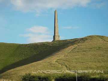
Preshute's best nearby historic monuments can be found at Lansdowne Monument, Cherhill White Horse, and Avebury.
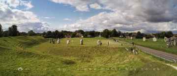
Preshute has some unmissable ancient sites nearby like Avebury, West Kennet Long Barrow, The Sanctuary, and Silbury Hill.
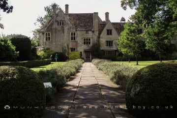
Don't miss Avebury Manor's historic buildings if visiting the area around Preshute.
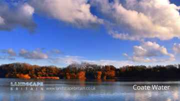
The area close to Preshute boasts some of the best country parks including Coate Water Country Park.
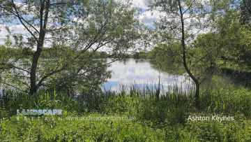
Places near Preshute feature a number of interesting lakes including Coate Water.
Places near Preshute feature a number of interesting villages including Ashton Keynes.
Preshute History
There are some historic monuments around Preshute:
- Bowl barrow 40m north west of East Kennett long barrow forming part of a cemetery
- Bowl barrow 800m south-east of Barbury Barn
- Bowl barrow 800m south-east of Ogbourne St Andrew Farm
- Disc barrow at Easton Clump
- Group of round barrows on Rough Hill
- Bowl barrow forming part of a Bronze Age cemetery 400m north-east of West Kennett Farm on Overton Hill
- Field system and earthwork enclosure on Burderop Down
- Bell barrow 200m north of Rockley Plantation
- Two bowl barrows 820m north of Rockley Manor: part of the Rockley Plantation barrow cemetery
- Bowl barrow 900m south west of the junction of the Ridgeway and Green Street, forming part of a round barrow cemetery on Avebury Down
- East Croft Coppice earthwork
- Bowl barrow 630m north east of Wick Bottom Barn
- Barbury Castle Farm deserted Medieval village
- Earthwork enclosure 950m SSE of Manor Farm
- Sharpridge field system
- West Kennet Avenue and an earthwork bank east of West Kennett Farm
- East Kennett long barrow, 600m south of East Kennett church
- Earthwork NW of New Town Farm
- Bowl barrow 800m north-east of Hackpen Barn
- Three Roman burial mounds, a Bronze Age bowl barrow, a pagan Saxon inhumation cemetery and a short length of Roman road on Overton Hill.
- Withy Copse ditch
- Bowl barrow 450m south-west of Savernake Lodge
- Prehistoric to post-medieval settlement, cultivation, industrial and funerary remains on Fyfield, Overton and Manton Downs
- Saucer barrow: part of a barrow cemetery west of Barbury Castle
- Bowl barrow 400m south-east of Culley's Farm Cottages
- Bowl barrow 275m west of Square Copse: part of the Square Copse barrow cemetery
- Bowl barrow 400m north-west of Aldbourne Warren Farm
- Martinsell Hill camp
- Bowl barrow 50m north east of East Kennett long barrow forming part of a cemetery
- Bowl barrow 850m WNW of Dudmore Lodge
- Lewisham Castle
- Three confluent round barrows 580m west of the Ridgeway, forming part of a Bronze Age round barrow cemetery on Avebury Down
- Barrow on Coombe Down, 1070yds (980m) NE of Upper Poughcombe
- Dam of King's fishpond
- Bell barrow 350m south-west of Barbury Barn
- Bowl barrow in The Belt, 350m north east of Hill Barn
- Disc barrow on Burderop Down, 1km north-east of Upper Herdswick Farm
- Two bowl barrows 680m north of Upper Herdswick Farm, Barbury Down
- Group of four round barrows 500m south-east of Avebury Down Barn, forming part of a Bronze Age round barrow cemetery on Avebury Down
- Langdean stone circle
- Bowl barrow 50m south of The Sanctuary on Overton Hill, forming part of the Seven Barrow Hill round barrow cemetery
- Easton Clump settlement
- Medieval settlement and prehistoric field system 520m north east and 760m east of Snap Farm
- Iron Age enclosure on Overton Hill, 600m north west of North Farm
- Village settlement on Barton Down
- Bowl barrow 70m north of Rockley Plantation
- Bowl barrow 750m south-east of Barbury Castle Farm
- Bowl barrow and a saucer barrow 200m north of Rockley Plantation
- Bowl barrow 120m west of East Kennett long barrow forming part of a cemetery
- Bell barrow 300m south-east of Avebury Down Barn forming part of a Bronze Age round barrow cemetery on Avebury Down
- Devil's Den long barrow, 600m east of White Acre
- Bowl barrow 50m south-east of the `Sanctuary' forming part of the Overton Hill round barrow cemetery.
- Two bowl barrows 400m south of Whitecomb Plantation
- Round barrow 750yds (690m) SE of Smeathe's Plantation
- Banjo enclosure 480m south west of Cheldene
- Barrow on Coombe Down, 930yds (830m) WSW of St George's Church
- Barrow on Smeathe's Ridge
- Knap Hill camp near Alton Priors
- Bowl barrow on Sugar Hill
- Medieval settlement remains at Overtown
- Group of four round barrows 300m north west of the junction between the Ridgeway and Green Street on Avebury Down
- Barbury Castle: a hillfort and bowl barrow
- Bowl barrow east of the Ridgeway forming part of the Overton Hill Bronze Age round barrow cemetery.
- Swanborough Tump
- Bowl barrow 70m north of Green Street and east of the Avebury henge monument
- Adam's Grave: a long barrow on Walker's Hill
- Bowl barrow 175m west of Square Copse: part of the Square Copse barrow cemetery
- Black Field Roman site
- Settlement and field system on Milton Hill (Fyfield Down)
- Pair of round barrows 400m west of the Ridgeway, forming part of a round barrow cemetery situated on Avebury Down
- Bell barrow 75m west of Red Shore
- Romano-British kilns, Column Ride, Savernake Forest
- Bowl barrow 690m north of Rockley Manor: part of the Rockley Plantation barrow cemetery
- Bowl barrow 1km north-east of Avebury and 70m north of Green Street
- Round barrow on Easton Down
- Bowl barrow 300m east of Ivy House Farm
- Three bowl barrows: part of a barrow cemetery west of Barbury Castle
- Bowl barrow 770m south west of the junction of the Ridgeway and Green Street, forming part of a round barrow cemetery on Avebury Down
- Three bell barrows and a pillow mound 400m south-west of Knap Cottage
- Romano-British kilns 150yds (135m) SSW of Tottenham House
- Bowl barrow on Sugar Hill
- Whitefield Hill ditch
- Bowl barrow 620m north of Rockley Manor: part of the Rockley Plantation barrow cemetery
- Bowl barrow 200m south of Green Street and 1100m east of the Avebury henge monument, forming part of a round barrow cemetery on Avebury Down
- Bowl barrow 400m south-east of Cadley Vicarage
- Earthwork enclosure and dewpond 490m north of Barbury Castle
- Earthwork W of New Town Farm
- Bowl barrow 650m ESE of New Barn, between Avebury Down and Monkton Down
- Moated site at Puthall Farm
- Linear earthwork in Savernake Forest, S of Great Lodge Bottom
- Bowl barrow 750m north of Rockley Manor: part of the Rockley Plantation barrow cemetery
- Bell barrow and adjacent bowl barrow on Marlborough Common, 120m east of Wootton Bassett Road
- Bowl barrow 150m north of Half Moon Wood
- Two enclosures on Winterbourne Down
- Bowl barrow 375m east of Wick Bottom Barn
- Group of six round barrows forming part of a Bronze Age cemetery 400m north-east of West Kennett Farm
- Two earthwork enclosures and a linear earthwork 625m north of Barbury Castle
- Wick Down Farm earthwork
- Linear barrow cemetery on Hackpen Hill
- Wansdyke: section from S of Furze Hill to Marlborough-Pewsey road
- West Kennett Farm palisaded enclosures
- Camp on Forest Hill
- Sharpridge earthworks
- Ditch 530yds (484m) SW of Stitchcombe Farm
- Bowl barrow 200m north of East Kennett long barrow forming part of a cemetery
- Bowl barrow 880m north of Rockley Manor: part of the Rockley Plantation barrow cemetery
- Bowl barrow 870m ESE of New Barn on Monkton Down
- Bowl barrow immediately west of the Ridgeway, 400m north east of its junction with Green Street
- Bowl barrow 700m south west of Liddington Warren Farm
- The Sanctuary, Overton Hill
- Medieval settlement remains immediately west of The Vicarage
- Enclosure on Ogbourne Down
- Three bowl barrows 600m south-west of Knap Cottage
- Saucer barrow 620m north of New Barn: Part of a barrow cemetery on Monkton Down
- Bowl barrow 750m east of New Barn
- Six bowl barrows 560m north of New Barn: part of a barrow cemetery on Monkton Down
- Bowl barrow 50m north of Barrow Farm
- Castle mound
- Bowl barrow 500m north-west of Berwick Bassett Clump
- Ogbourne Maizey Down round barrow
- Bowl barrow 300m south-east of Walker's Plantation
- Bowl barrow 1km west of Sheppard's Farm Dairy
- Bowl barrow 1450m south of Barbury Castle Farm
- Crowdown Clump earthwork (Godsbury)
- Bowl barrow 850m north west of North Farm
- Medieval settlement, cultivation remains and boundary 550m north west of Upham Hall
- Group of five round barrows north-east of the Sanctuary: part of the Overton Hill round barrow cemetery.
- Bell barrow forming part of a round barrow cemetery 400m north-east of West Kennett Farm on Overton Hill
- Church Hill earthwork
- Long barrow in Barrow Copse
- Preshute Down field system
- Bowl barrow 500m west of The Row
- Giant's Grave (Martinsell Hill)
- Group of barrows on Draycott Hill
- The Giant's Grave round barrow cemetery
- Penning bell barrow 600m east of Avebury Down Barn
- Barrow 350yds (320m) E of Smeathe's Plantation, Ogbourne Down
- Pair of round barrows forming part of the Bronze Age round barrow cemetery 400m north-east of West Kennett Farm
- Earthworks on Marlborough Common
- Wansdyke: section 610yds (560m) NW of Wernham Farm to 250yds (230m) SW of New Buildings
- Two bowl barrows 400m east of Cadley Vicarage
- Mound in churchyard
- Two bowl barrows in Shipley Bottom
- Two round barrows W of New Town Farm
- 'Giant's Grave' long barrow on Milton Hill
- Barrow on Avebury Down, S of track from Avebury
- Bowl barrow 200m east of East Kennett long barrow forming part of a barrow cemetery
- Bowl barrow 880m north east of Lower Upham Farm
- Five bowl barrows 600m north-east of Brimslade Farm Cottages: part of the Square Copse barrow cemetery