Pitton
Pitton is a Village in the county of Wiltshire.
Pitton postcode: SP5 1EE
There are great places to visit near Pitton including some great historic monuments, ancient sites, historic buildings, country parks, lakes and villages.
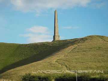
Pitton's best nearby historic monuments can be found at Lansdowne Monument, Cherhill White Horse, and Avebury.
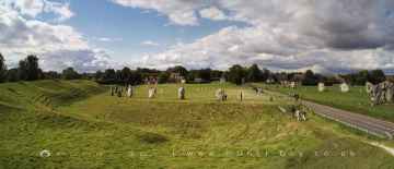
There are a several good ancient sites in the Pitton area like Avebury, West Kennet Long Barrow, The Sanctuary, and Silbury Hill.
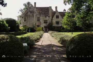
Avebury Manor is a great place to visit close to Pitton if you like historic buildings.
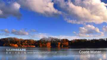
Pitton is near some unmissable country parks like Coate Water Country Park,
Lakes to visit near Pitton include Coate Water.
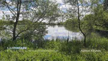
There are a several good villages in the area around Pitton like Ashton Keynes.
Pitton History
There are some historic monuments around Pitton:
- Bowl barrow 100m north of the A303 on Countess Farm
- Bowl barrow 650m ESE of Manor Farm: one of a group of round barrows on Porton Down
- Circular earthwork
- Two bowl barrows and a levelled barrow 460m north east of Normanton House on Amesbury Down
- Bronze Age enclosure and linear boundary earthwork on Boscombe Down East
- Medieval pottery kilns, Milford Farm
- Vespasian's Camp
- West Dean Roman villa
- Bowl barrow 450m ENE of Manor Farm: one of a group of round barrows on Porton Down
- Lynchets at Southmill Hill
- Bowl barrow 250m north of the A303 on Countess Farm
- Long barrow, Winterbourne
- Saucer barrow 400m north east of the sports ground: one of a group of round barrows north west of Idmiston Down
- Bowl barrow 130m WSW of Andover Lodge: part of a round barrow cemetery in Barrow Field Clumps, Cholderton Park
- Clarendon Palace
- Bowl barrow 680m SSE of the southern corner of Moll Harris's Clump: one of a group of round barrows on Porton Down
- Bowl barrow 320m north east of Straight Walk Plantation: one of a group of round barrows south of Hampshire Gap
- Bowl barrow 750m NNE of Easton Down Farm
- Bowl barrow immediately south of the embankment of a disused railway, within Boscombe Down Airfield, 870m south east of The Pennings
- The Giant's Chair bell barrow
- Castle Copse camp
- The Moot: a ringwork and bailey, earlier Roman settlement remains and later garden earthworks immediately east of the River Avon
- Enclosure NW of Downbarn West
- Wick Down round barrow
- Churchyard cross
- Ratfyn Barrow
- Bell barrow 300m ENE of the sports ground: one of a group of round barrows north west of Idmiston Down
- Two bowl barrows 200m north of the A303 on Countess Farm
- Round barrow cemetery 250m east of Straight Walk Plantation
- Roman earthwork
- Two bowl barrows 265m south of the southern corner of Moll Harris's Clump: part of a group of round barrows on Porton Down
- Bell barrow 650m east of the Pennings, Earl's Farm Down
- Linear boundary earthwork 250m west of Stockport
- Bowl barrow 530m SSW of the southern corner of Moll Harris's Clump: one of a group of round barrows on Porton Down
- The Mount round barrow
- Clearbury Ring
- Three bell barrows 300m north-east of New Barn, Earl's Farm Down
- Village cross
- Bowl barrow at the east end of Earl's Farm Down
- Barrow cemetery 730m north of Hampshire Gap
- Ogbury camp
- Bell barrow 250m NNE of the sports ground: one of a group of round barrows north west of Idmiston Down
- Linear boundary earthwork on Amesbury Down west of Stock Bottom
- Flint mines, linear boundary and two bowl barrows at Martin's Clump, Porton Down
- Harnham Bridge
- Disc barrow and pillbox within Boscombe Down airfield, 520m south east of the Officers' Mess
- Long barrow 500m west of Croft Farm
- Bowl barrow 320m west of Vespasian's Camp
- Bowl barrow 200m north of the A303 on Countess Farm
- Three round barrows 100m north west of Andover Lodge: part of a round barrow cemetery in Barrow Field Clumps, Cholderton Park
- West Dean Roman villa
- 'Ende Burgh' long barrow
- Three ditched bowl barrows south of Andover Lodge: part of a round barrow cemetery in Barrow Field Clumps, Cholderton Park
- Bowl barrow 340m WSW of Andover Lodge: part of a round barrow cemetery in Barrow Field Clumps, Cholderton Park
- Two bowl barrows 380m north east of Straight Walk Plantation: part of a group of round barrows south of Hampshire Gap
- Wilbury House round barrow
- Bowl barrow 250m south of Martin's Clump
- Bowl barrow 250m south east of Tower Hill
- Iron Age fort in Ashley's Copse
- Stonehenge, the Avenue, and three barrows adjacent to the Avenue forming part of a round barrow cemetery on Countess Farm
- Bronze Age enclosure and two bowl barrows 520m north east of Moll Harris's Clump on Idmiston Down
- Long barrow and adjoining bowl barrow, 250m south of Martin's Clump
- Bowl barrow 370m east of Manor Farm: one of a group of round barrows on Porton Down
- Two bowl barrows 200m south of Laundry Bungalows
- Bell barrow and bowl barrow 500m NNW of Long Orchard
- City rampart E of Council House
- Bowl barrow 260m SSW of Laundry Bungalows
- Odstock Copse earthwork
- Quarley Hill camp
- Bowl barrow 795m WSW of Franklin's Well
- Bell barrow, three bowl barrows and gas testing trenches on Idmiston Down
- Roman road between A30 main road and Winterslow Corner
- Bowl barrow 780m NNE of Hampshire Gap
- Bowl barrow on the Amesbury/Bulford Boundary north of the A303
- Pond barrow 480m west of Olddown Barn on Amesbury Down
- Tithe barn, Roche Old Court
- Round barrow E of Downbarn West
- Barrows forming part of a cemetery, 320m north west of The Pheasant Hotel
- Horse Barrow
- Three bowl barrows 200m east of Manor Farm: part of a group of round barrows on Porton Down
- Bowl barrow 260m SSE of the southern corner of Moll Harris's Clump: one of a group of round barrows on Porton Down
- Fussell's long barrow
- Round barrow cemetery in New Plantation 590m ESE of Amesbury Junction
- Clearbury Down round barrow
- Bowl barrow 260m north of the A303 on Countess Farm
- Bowl barrow 950m east of New Barn, Earl's Farm Down
- Two bowl barrows 400m west of Easton Down Farm: part of a group of round barrows south of Easton Down
- Three bowl barrows 220m west of Vespasian's Camp
- Roman villa at East Grimstead
- Section of Roman road by Upper and Lower Noad's Copse
- Bowl barrow on Earl's Farm Down within Boscombe Down Airfield, 620m south west of the covered reservoir
- Bowl barrow 80m north of the A303, north east of Vespasian's Camp
- Bowl barrow within Boscombe Down Airfield, 160m south east of The Rifle and Pistol Club
- Two disc barrows and two bowl barrows 900m north of Moll Harris's Clump on Idmiston Down
- The Giant's Grave long barrow
- Bowl barrow 200m south west of Andover Lodge: part of a round barrow cemetery in Barrow Field Clumps, Cholderton Park
- Bowl barrow 535m SSW of the southern corner of Moll Harris's Clump: one of a group of round barrows on Porton Down
- Bowl barrow 150m north of the A303 on Countess Farm
- Figsbury Ring
- Bowl barrow 50m west of the Battery Hill triangulation point
- Bell barrow 800m east of New Barn, Earl's Farm Down
- Gomeldon deserted village
- Bowl barrow 440m SSW of the southern corner of Moll Harris's Clump: one of a group of round barrows on Porton Down
- Bell barrow, bowl barrow and section of hollow way 600m NNW of Long Orchard
- Three bowl barrows 250m west of Andover Lodge: part of a round barrow cemetery in Barrow Field Clumps, Cholderton Park
- Long barrow 140m WSW of the Battery Hill triangulation point
- Queensberry Bridge
- Iron Age hillfort in Ashley's Copse
- Bowl barrow 375m WNW of Easton Down Farm: part of a group of round barrows south of Easton Down
- Newton Barrows, a round barrow cemetery on Earl's Farm Down
- The Poultry Cross
- Templeman's Farm round barrow
- Bowl barrow 125m north-east of South View Farm
- Bell barrow 550m east of New Barn, Earl's Farm Down
- Bowl barrow 340m east of Stockport
- Triple bell barrow 530m north of Field Barn on Amesbury Down
- Woodbury ancient villages
- Bowl barrow 140m north of the A303 on Countess Farm
- A pond barrow and a bowl barrow 200m south east of St Mary's Church forming outliers to a round barrow cemetery at Winterbourne Gunner
- Two disc barrows and a bell barrow, 400m east of the Pennings, Earl's Farm Down
- Milford Hill Bridge