Laverstock
Laverstock is a Village in the county of Wiltshire.
Laverstock postcode: SP1 1PF
There are great places to visit near Laverstock including some great historic monuments, ancient sites, historic buildings, country parks, lakes and villages.
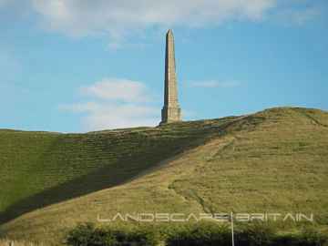
There are a number of historic monuments near Laverstock including Lansdowne Monument, Cherhill White Horse, and Avebury.
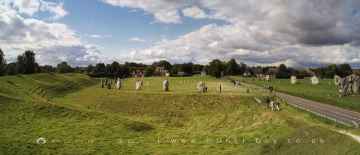
Avebury, West Kennet Long Barrow, The Sanctuary, and Silbury Hill are some of Laverstock best ancient sites to visit near Laverstock.
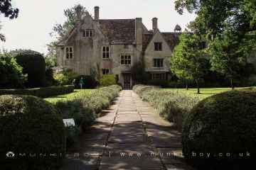
The area close to Laverstock boasts some of the best historic buildings including Avebury Manor.
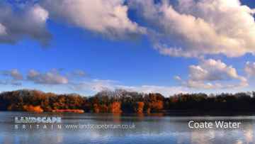
The area around Laverstock's best country parks can be found at Coate Water Country Park.
The area around Laverstock's best lakes can be found at Coate Water.
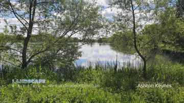
Don't miss Ashton Keynes's villages if visiting the area around Laverstock.
Laverstock History
There are some historic monuments around Laverstock:
- Linear boundary from south east of Winterbourne Stoke crossroads to south west of The Diamond on Wilsford Down
- Enclosure NW of Downbarn West
- Bowl barrow 470m south east of Druid's Head Farm
- Long barrow in Round Clump
- Giant's Grave: a long barrow 400m north-west of Down Farm
- Long barrow, Winterbourne
- Two bowl barrows 265m south of the southern corner of Moll Harris's Clump: part of a group of round barrows on Porton Down
- Ogbury camp
- Bowl barrow on Earl's Farm Down within Boscombe Down Airfield, 620m south west of the covered reservoir
- The Moot: a ringwork and bailey, earlier Roman settlement remains and later garden earthworks immediately east of the River Avon
- Harnham Bridge
- A pond barrow and a bowl barrow 200m south east of St Mary's Church forming outliers to a round barrow cemetery at Winterbourne Gunner
- Newton Barrows, a round barrow cemetery on Earl's Farm Down
- Three bowl barrows on the southern edge of Luxenborough Plantation
- Ruined church of SS Mary and Nicholas
- Long barrow 700m north-west of Tenantry Farm
- Bowl barrow within Boscombe Down Airfield, 160m south east of The Rifle and Pistol Club
- Rockbourne Down, Spring Pond enclosure
- Churchyard cross
- Horse Barrow
- Linear boundary earthwork 250m west of Stockport
- Triple bell barrow 530m north of Field Barn on Amesbury Down
- Wick Down round barrow
- Grim's Ditch
- 'Ende Burgh' long barrow
- Two bowl barrows 700m south of Springbottom Farm buildings
- Whitsbury hillfort
- Bowl barrow 440m SSW of the southern corner of Moll Harris's Clump: one of a group of round barrows on Porton Down
- Bowl barrow 100m north of Rox Hill Clump
- Bowl barrow 250m south of Westfield Farm buildings
- Linear boundary earthwork on Amesbury Down west of Stock Bottom
- Bowl barrow 50m west of the Battery Hill triangulation point
- Duck's Nest: a long barrow on Rockbourne Down
- Group of barrows on North Hill Down
- City rampart E of Council House
- Churchyard cross
- Bowl barrow 50m south west of Rox Hill Clump
- Bowl barrow 400m south east of Longbarrow Cross Roads, east of A360
- Bell barrow 300m ENE of the sports ground: one of a group of round barrows north west of Idmiston Down
- Bowl barrow forming part of Normanton Down round barrow cemetery
- Bowl barrow 430m north west of Northdown Barn
- Heale Hill round barrows and earthworks
- Three bowl barrows 150m south of Normanton Down round barrow cemetery
- Two disc barrows and two bowl barrows 900m north of Moll Harris's Clump on Idmiston Down
- Bowl barrow 340m east of Stockport
- Bowl barrow 530m SSW of the southern corner of Moll Harris's Clump: one of a group of round barrows on Porton Down
- Grans barrow: a long barrow 880m west of Down Farm
- Clearbury Ring
- Bell barrow 250m NNE of the sports ground: one of a group of round barrows north west of Idmiston Down
- Two round barrows 300m south of Normanton Down round barrow cemetery
- Gomeldon deserted village
- Bowl barrow 100m south east of the southern edge of The Diamond south of the A303
- Bowl barrow 700m north of Springbottom Farm
- Deserted medieval village, a bowl barrow, and part of a prehistoric field system opposite Lake House in Lake Bottom
- Bowl barrow forming part of the Normanton Down round barrow cemetery
- Bowl barrow 200m WNW of Lake House
- Bowl barrow 200m east of Lake Down round barrow cemetery north of Rox Hill
- Barrow in Wilton Park
- Newton Barrow
- The Giant's Chair bell barrow
- Ten round barrows forming the Lake Down round barrow cemetery and a section of linear boundary crossing Lake Down
- Bowl barrow 680m SSE of the southern corner of Moll Harris's Clump: one of a group of round barrows on Porton Down
- Roman road between A30 main road and Winterslow Corner
- Disc barrow forming part of the Normanton Down round barrow cemetery
- The Giant's Grave long barrow
- Bowl barrow 400m south of Normanton Gorse
- Henge monument 300m south of Longbarrow Cross Roads, east of A360
- Pond barrow 480m west of Olddown Barn on Amesbury Down
- Bowl barrow 250m south west of Longbarrow Cross Roads, west of A360
- Long barrow 140m WSW of the Battery Hill triangulation point
- Medieval pottery kilns, Milford Farm
- Two barrows NW of Little Down
- Milford Hill Bridge
- Two bowl barrows and a levelled barrow 460m north east of Normanton House on Amesbury Down
- Group of barrows W of Hooklands Plantation
- Templeman's Farm round barrow
- Bell barrow north east of Westfield Farm and 150m south of Wilsford round barrow cemetery
- Old Sarum
- Earthwork W of Woodford Clump
- Romano-British settlement at Stratford sub Castle
- Knap barrow: a long barrow 900m west of Down Farm
- Disc barrow and pillbox within Boscombe Down airfield, 520m south east of the Officers' Mess
- Lake Barrow Group, North Kite earthwork enclosure, four sections of linear boundary, and a bowl barrow within the North Kite
- Bowl barrow 450m east of The Diamond south of the A303
- Bowl barrow 540m south east of Druid's Head Farm
- Mizmaze on Breamore Down
- Ten bowl barrows, five disc barrows, a bell barrow, a pond barrow and a saucer barrow forming the Wilsford round barrow cemetery
- Long barrow 350m south west of the Normanton Down round barrow cemetery
- Bowl barrow 535m SSW of the southern corner of Moll Harris's Clump: one of a group of round barrows on Porton Down
- Three bowl barrows 200m east of Manor Farm: part of a group of round barrows on Porton Down
- Seven bowl barrows and a pond barrow forming a round barrow cemetery 200m north of The Diamond on Wilsford Down
- Bowl barrow forming part of a round barrow cemetery 350m north of Springbottom Farm buildings on Wilsford Down
- Woodbury ancient villages
- Odstock Copse earthwork
- Fussell's long barrow
- Figsbury Ring
- Bowl barrow 450m north of Springbottom Farm
- Bowl barrow 370m east of Manor Farm: one of a group of round barrows on Porton Down
- Bowl barrow immediately south of the embankment of a disused railway, within Boscombe Down Airfield, 870m south east of The Pennings
- Bowl barrow on Homington Down, 725m south of Tottens Farm
- Bowl barrow 300m north west of Lake House
- Long barrow on Little Toyd Down, 760m south west of Grims Lodge Farm
- Packhorse bridge
- Bronze Age enclosure and two bowl barrows 520m north east of Moll Harris's Clump on Idmiston Down
- Long barrow on Wilsford Down 300m north of The Diamond
- Village cross
- Long barrow 600yds (550m) SE of Vanity
- Six bowl barrows forming the greater part of a round barrow cemetery on Wilsford Down 350m north of Springbottom Farm buildings
- Bowl barrow 450m ENE of Manor Farm: one of a group of round barrows on Porton Down
- Bowl barrow 650m ESE of Manor Farm: one of a group of round barrows on Porton Down
- Bowl barrow 120m south of Normanton Down round barrow cemetery
- Saucer barrow 400m north east of the sports ground: one of a group of round barrows north west of Idmiston Down
- Bowl barrow on Little Toyd Down, 650m south west of Grims Lodge Farm
- Bowl barrow forming part of a round barrow cemetery 350m north of Springbottom Farm buildings on Wilsford Down
- Section of a linear boundary from 350m north east of Westfield Farm on Lake Down to Lake Bottom
- Bowl barrow 260m SSE of the southern corner of Moll Harris's Clump: one of a group of round barrows on Porton Down
- Round barrow E of Downbarn West
- Bowl barrow south of Normanton Gorse on the southern edge of Normanton Down
- Two bowl barrows 700m north west of Normanton Down House
- The Poultry Cross
- Clearbury Down round barrow
- Ancient cultivation terraces
- Clarendon Palace
- Roman earthwork
- Bowl barrow 250m north west of Lake House
- Bell barrow, three bowl barrows and gas testing trenches on Idmiston Down
- Lynchets at Southmill Hill
- Round barrow SE of Cowdown Farm