


Elveden is a Village in the county of Suffolk.
There are great places to visit near Elveden including some great fens, nature reserves, historic buildings, villages and historic monuments.
There are a several good fens in the area around Elveden like Lopham Fen.
There are a several good nature reserves in the area around Elveden like Lopham Fen.
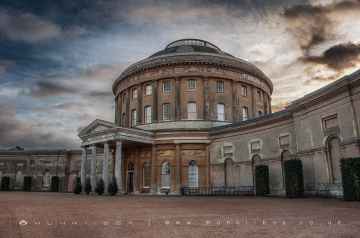
There are a number of historic buildings near to Elveden including Ickworth.
Villages to visit near Elveden include Elveden.
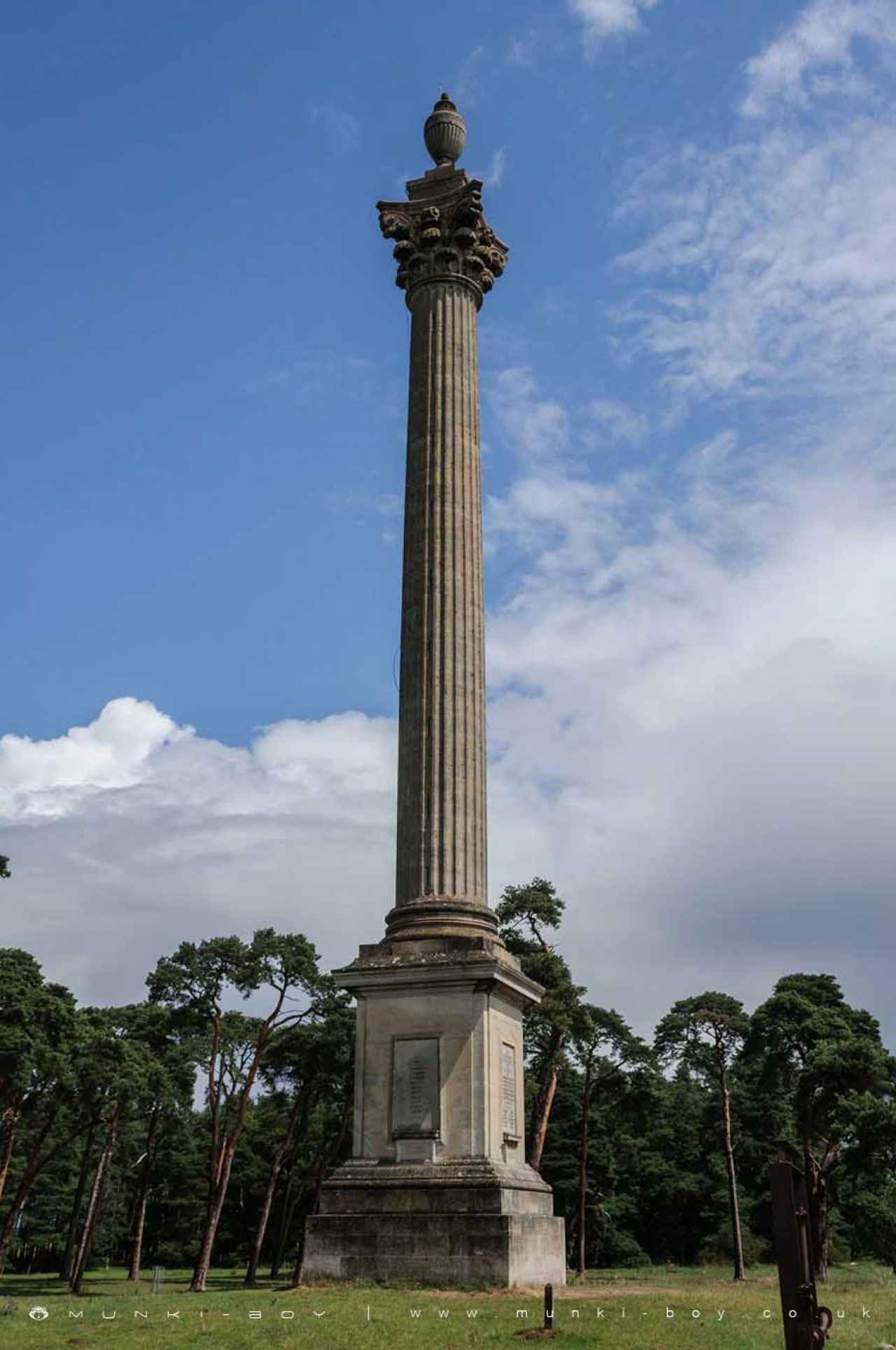
Elveden is near some unmissable historic monuments like Elveden Monument,
Elveden History
There are some historic monuments around Elveden:
- Site of Saxon town: plot on E side of Mill Lane 200ft (60m) N of Nunthorpe House
- Site of Saxon town: primary school grounds, Hilary Road
- Devil's Dyke (Fossdyke or Fendyke)
- Bowl barrow 380m south west of Santon House
- Site of Saxon town: Nuns' Bridges open space
- Site of Saxon town: Bury Road allotments
- Priory of the Canons of the Holy Sepulchre and part of Saxon town
- Bowl barrow known as John Mann's Clump
- Cavenham Bridge
- Bowl barrow 100m south east of Woodcock Cottage
- Bell barrow known as White Hill
- Bowl barrow on north west edge of Gibson's Slip, 220m north west of Gate Lodge
- An Iron Age religious site and associated enclosures on Gallows Hill, Thetford, immediately to the north of Fison Way industrial estate
- Bowl barrow known as Traveller's Hill tumulus
- Thetford Warren Lodge
- Bowl barrow 230m south west of Little Lodge Farm
- Melford Bridge
- Bowl barrow 580m north east of The Lodge, Brandon
- Bowl barrow known as Blood Hill with associated remains of a boundary bank
- Bank and ditch NE of London Road
- Site of St Ethelred's Church and adjoining area to south
- Three bowl barrows and a ring ditch 850m and 750m north east of Neville House Farm
- Bowl barrow known as Hill of Health, Brockley Corner
- Round barrow called Cuckoo Hill
- Castle Hill: motte and bailey castle, Iron Age earthwork enclosure and site of Augustinian friary
- Five bowl barrows 590m north east of Bernersfield Farm
- Bowl barrow known as How Hill, east of Heronfield Belt
- Two bowl barrows 560m east of Emily's Wood
- Bowl barrow 780m south west of Bernersfield Farm
- Roman building E of Fengate Farm
- Bowl barrow in the garden of The Old Mill
- Leylands Farm Romano-British site, Hockwold
- Site of Saxon town including site of St John's churchyard on playing fields
- Red Castle medieval ringwork, church and Saxon settlement remains
- Area of Saxon town N of Red Castle
- Grimes Graves, including round barrow in Grimes Graves Plantation
- Santon moated site and associated medieval settlement
- Pepper Hill bowl barrow, 400m north east of Mill Farm
- Mickle Hill
- Bowl barrow in Dixon's Covert
- Site of St Helen's Church with adjacent earthworks and holy well
- Bowl barrow 650m south east of Telegraph Plantation
- Atomic bomb store on Thetford Heath
- Tutt Hill barrow, near Thetford
- Thetford Cluniac priory
- Two Pickett-Hamilton forts at Honington airfield, 750m and 1.25km south west of Broomhill Cottages
- Bowl barrow 720m north east of East Farm
- Blackfriars
- Site of Saxon town: car park to N of Anchor Hotel
- Two bowl barrows on Troston Heath, one known as Black Hill
- Site of town ditch: Icknield Way allotments
- Civil War sconce near Farthing Bridge
- Middle Saxon occupation on Chequer Meadow
- Weeting Castle moated site and 12th century manor house with post-medieval ice house
- Bowl barrow 510m south east of Bernersfield Farm
- Settlement site W of Hengrave mill
- Bowl barrow in the King's Forest, 1.3km north east of Wideham Barn
- Roman villa SW of Weatherhill Farm
Places to see near Elveden

Lakes near Elveden
Rivers near Elveden
- Lark - Fynn (d/s confluence)
- Shottisham Mill River
- Earl Soham Watercourse
- Lark
- Deben (u/s Brandeston Bridge)
- Byng Brook
- Deben (Brandeston Bridge - Melton)
- Bucklesham Mill River
- Fynn
- Potsford Brook
- Chediston Watercourse
- Hundred River
- Butley River
- Leiston Beck
- Fromus
- Easton Broad
- Alde
- Blyth (Huntingfield tributary)
- Black Ditch (East Suffolk)
- Wang
- Wenhaston Watercourse
- Lothingland Hundred
- Blyth (d/s Halesworth)
- Alde - Ore (d/s confluence)
- Minsmere Old River
- Blyth (u/s Halesworth)
- Blyth (Laxfield - Hevingham Hall)
- Ore
- Blyth (Hevingham Hall - d/s Halesworth)
- Blyth (New Reach through Halesworth)
- Tang
- Wattisham Watercourse
- Jordan (East Suffolk)
- Somersham Watercourse
- Rattlesden River (d/s Gt. Finborough)
- Gipping (u/s Stowmarket)
- Great Finborough Watercourse
- Gipping (d/s Stowmarket)
- Coddenham Watercourse
- Haughley Watercourse
- Gipping (through Stowmarket)
- Rattlesden River (u/s confluence with Gt. Finborough)
- Belstead Brook
- Spixworth ( and Dobbs) Beck
- Bure (Horstead Mill to St Benet's Abbey)
- East Ruston Stream
- Thurne
- North Walsham and Dilham Canal (disused)
- Mermaid Stream
- Bure (u/s confluence with Scarrow Beck)
- Smallburgh Watercourse
- Ant (Dilham to R. Bure)
- King's Beck
- Bure (Scarrow Beck to Horstead Mill)
- Scarrow Beck
- Muck Fleet
- Hevingham Watercourse
- New Cut
- Starston Brook
- Waveney (u/s Frenze Beck)
- Waveney (Ellingham Mill - Burgh St. Peter)
- Waveney (R Dove - Starston Brook)
- Waveney (Frenze Beck to Dove)
- Metfield Stream
- Dove trib - Finningham
- Dove
- Frenze Beck
- Waveney (Starston Brook - Ellingham Mill)
- Tributary of Upper Waveney
- Dove trib - Eye
- Broome Beck
- Chickering Beck
- Tributary of Waveney
- The Beck
- Mendlesham Stream
- Dickleburgh Stream
- Buckenham Stream
- Stow Bedon Stream
- Hopton Brook
- Little Ouse (Hopton Common to Sapiston Confl)
- Larling Brook
- Pakenham Stream
- Thelnetham Brook
- Little Ouse (Thelnetham to Hopton Common)
- Sapiston River
- Whittle
- Stowlangtoft Stream
- Stanton Tributary
- Little Ouse River
- Little Ouse (Sapiston Confluence to Nuns' Br)
- Thet (DS Swangey Fen)
- Sapiston
- Thet (US Swangey Fen)
- Little Ouse (US Thelnetham)
- Cut-off Channel
- Old West River
- Ely Ouse (South Level)
- Cavenham Stream
- Lark (Hawstead to Abbey Gardens)
- Lee Brook
- Lark downstream of Mill Street Bridge
- Lark (US Hawstead)
- Culford Stream
- Hawstead Tributary
- Kennett-Lee Brook
- Linnet
- Tuddenham Stream
- Kennett - Lee Brook
- Lark (Abbey Gardens to Mildenhall)
- Wrabness Brook
- Glem - Lower
- Chad Brook
- Glem - Upper
- Bumpstead Brook
- Brett
- Old River Brett
- Stour Brook
- Stour (u/s Wixoe)
- Lavenham Brook
- Stutton Brook
- Stour (d/s R. Brett)
- Chilton Brook
- Bildeston Brook
- Belchamp Brook
- Box
- Ramsey River
- Stour (Lamarsh - R. Brett)
- Stour (Wixoe - Lamarsh)
- Eastwood Brook
- Crouch (A129 - Wickford)
- Roach
- Crouch (d/s Wickford)
- Rettendon Brook
- Noblesgreen Ditch
- Crouch (Upper) - u/s A129
- Prittle Brook


