Strathblane
Strathblane is a Village in the county of Stirling.
Strathblane postcode: G63 9BE
There are great places to visit near Strathblane including some great cities and historic monuments.
Stirling is one of Strathblane's best, nearby cities to visit in Strathblane.
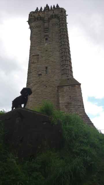
Wallace Monument is a great place to visit close to Strathblane if you like historic monuments.
Strathblane History
There are some historic monuments around Strathblane:
- Cochno, cup and ring marked stone 115m SW of Silver Firs Prehistoric ritual and funerary: cupmarks or cup-and-ring marks and similar rock art SM716
- Antonine Wall, field boundary S of Boclair to Crow Hill Roman: Antonine Wall SM7480
- Harvieston,deserted village E of Secular: settlement, including deserted, depopulated and townships SM3394
- Antonine Wall and Military Way, 515m N of Crofthead Cottage Roman: Antonine Wall SM7551
- Woodend,motte Secular: motte SM2239
- Antonine Wall and fortlet, 950m W to 335m ENE of Cleddens Roman: Antonine Wall SM6836
- Antonine Wall, Ferguston Muir to New Kilpatrick Cemetery Roman: Antonine Wall SM7340
- Craigmaddie House, fort and castle 140m E of Prehistoric domestic and defensive: fort (includes hill and promontory fort); Secular: castle SM1749
- Dunmore,fort Prehistoric domestic and defensive: fort (includes hill and promontory fort) SM2575
- Antonine Wall, Summerston to River Kelvin Roman: Antonine Wall SM7497
- Antonine Wall, New Kilpatrick Cemetery Roman: Antonine Wall SM7341
- Antonine Wall, Iain Road to path N of Westbourne Crescent Roman: Antonine Wall SM6899
- Forth and Clyde Canal: Cleveden Road - Bishopbriggs Golf Course Industrial: inland water SM6773
- Antonine Wall, NE corner of Balmuildy Road to Cawder House access Roman: Antonine Wall SM7548
- Dumgoyach,standing stones 410m SE of Prehistoric ritual and funerary: standing stone SM2536
- Broadgate,mound 200m S of Prehistoric ritual and funerary: mound (ritual or funerary) SM4765
- Fintry,motte 400m WSW of Fintry Bridge Secular: motte SM2229
- Antonine Wall, Cawder House access road to canal towing path Roman: Antonine Wall SM7550
- Antonine Wall, 270m S of Buchley to 25m SW of Buchley Lodge Roman: Antonine Wall SM7547
- Forth and Clyde Canal: Blairdardie Road - Netherton Farm Industrial: inland water SM6775
- High Blochairn,cairn 180m WSW of Prehistoric ritual and funerary: cairn (type uncertain) SM2539
- Forth and Clyde Canal: Duntreath Avenue - Blairdardie Road Industrial: inland water SM6776
- Dunbeg,fort 700m W of Fintry Bridge Prehistoric domestic and defensive: fort (includes hill and promontory fort) SM5681
- Kettlehill,dun Prehistoric domestic and defensive: dun SM2190
- Antonine Wall, Peel Glen Road to Castlehill Roman: Antonine Wall SM6839
- Antonine Wall, Crow Hill to Balmore Road Roman: Antonine Wall SM7479
- Queen's View, burnt mound 500m S of Catythirsty Well Prehistoric domestic and defensive: burnt mound SM7001
- Antonine Wall, Cleddans Burn to Peel Glen Road Roman: Antonine Wall SM6838
- Knochraich,standing stone 340m NW of Prehistoric ritual and funerary: standing stone SM2696
- Bearsden Station,Roman bath-house 400m NE of Roman: Antonine Wall SM90334
- Forth and Clyde Canal: Linnvale - Duntreath Avenue Industrial: inland water SM6777
- Forth and Clyde Canal: Glasgow Branch Industrial: inland water SM6771
- Antonine Wall,Bearsden,Roman fort Roman: Antonine Wall SM3662
- Mugdock Castle,Milngavie Secular: castle SM2805
- Antonine Wall, Antonine Road to Rosslyn Road Roman: Antonine Wall SM6898
- Antonine Wall, 120m NE of Balmuildy Cottages to 270m S of Buchley Roman: Antonine Wall SM7543
- Woodhead House Secular: castle SM6252
- Forth and Clyde Canal: Bishopbriggs Golf Course Industrial: inland water SM6772
- Quinlochmore, fort 450m E of Catythirsty Well Prehistoric domestic and defensive: fort (includes hill and promontory fort) SM7000
- Antonine Wall, Roman temporary camp 450m W of Buchley Farm Roman: Antonine Wall SM3203
- Antonine Wall, River Kelvin to 120m NE of Balmuildy Cottages Roman: Antonine Wall SM7542
- Forth and Clyde Canal: Netherton Farm - Cleveden Road Industrial: inland water SM6774
- Antonine Wall, New Kilpatrick Cemetery to field boundary S of Boclair Roman: Antonine Wall SM7342
- Antonine Wall, Balmore Road to Summerston Roman: Antonine Wall SM7496