Cowie
Cowie is a Village in the county of Stirling.
Cowie postcode: FK7 7AW
There are great places to visit near Cowie including some great cities and historic monuments.
The area close to Cowie boasts some of the best cities including Stirling.
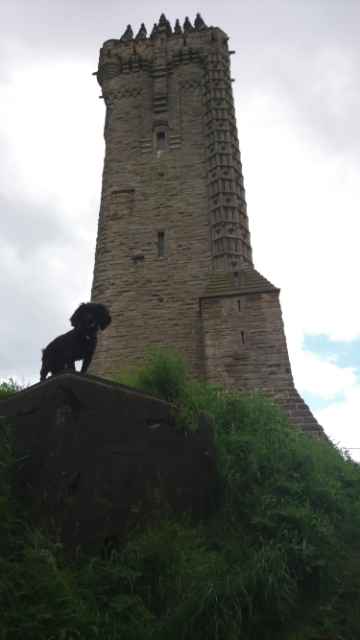
Don't miss Wallace Monument's historic monuments if visiting the area around Cowie.
Cowie History
There are some historic monuments around Cowie:
- Airth Old Church,church,Airth Castle Ecclesiastical: church SM2228
- Antonine Wall, W and E of Watling Lodge, Tamfourhill Roman: Antonine Wall SM90016
- Tullibody,old parish church Ecclesiastical: church SM626
- Carr's Hill,fort,Torwood Prehistoric domestic and defensive: fort (includes hill and promontory fort) SM1731
- Sauchinford Cottages,ring ditch 300m SSE of Prehistoric domestic and defensive: house SM6479
- Stirling,Argyll Lodging,house Secular: house SM90286
- Sauchinford Cottages, palisaded enclosure 100m ENE of Prehistoric domestic and defensive: palisaded enclosure SM6548
- Pendreich,cairn 1000m ENE of Prehistoric ritual and funerary: cairn (type uncertain) SM2537
- Sauchie Tower, tower and house Secular: tower SM629
- Alloa Glass Works,glass cone Industrial: glass SM3746
- Antonine Wall, 80m SW of Woodhouse Eaves to Underwood Cottage Roman: Antonine Wall SM7739
- Calderfield, enclosure 150m SW of Prehistoric domestic and defensive: enclosure (domestic or defensive) SM6543
- Antonine Wall, 495m WSW and 125m SE of Bonnyside House Roman: Antonine Wall SM8207
- Antonine Wall, Rough Castle to Lime Road, and field system Prehistoric domestic and defensive: field or field system; Roman: Antonine Wall SM8244
- Antonine Wall, Watling Lodge fortlet, Tamfourhill, Falkirk Roman: Antonine Wall SM8453
- Wester Carmuirs,Roman camp 640m SE of Roman: camp SM3188
- Stirling Castle Secular: castle SM90291
- Plean Cottages,palisaded enclosure 350m SSE of Prehistoric domestic and defensive: palisaded enclosure SM6480
- Antonine Wall, Milnquarter, Roman temporary camp 240m SE of Roman: Antonine Wall SM3242
- Myot Hill,fort Prehistoric domestic and defensive: fort (includes hill and promontory fort) SM2381
- West Plean Colliery No.3 Pit,coke ovens Industrial: coal SM4151
- Abbey Craig,fort Prehistoric domestic and defensive: fort (includes hill and promontory fort) SM2542
- Wester Carmuirs, enclosures 50m E of Prehistoric domestic and defensive: palisaded enclosure SM6414
- Antonine Wall, Seabegs Wood, rampart, ditch and Military Way Roman: Antonine Wall SM90014
- Househill,enclosure and part of Roman camp 250m SSW of Prehistoric domestic and defensive: enclosure (domestic or defensive); Roman: camp SM6483
- Antonine Wall, Dalnair to Seabegs Wood, including fortlet and camp Roman: Antonine Wall SM7742
- Logie Old Church, church and churchyard 30m SE of Garden Cottage Crosses and carved stones: tombstone; Ecclesiastical: church SM2798
- Antonine Wall, Rough Castle fort, annexe and Military Way Roman: Antonine Wall SM90013
- Fairy Knowe,cairn,Hill of Airthrey Prehistoric ritual and funerary: cairn (type uncertain) SM2543
- Castle Law,fort 400m SW of summit of Dumyat Prehistoric domestic and defensive: fort (includes hill and promontory fort) SM2182
- Doghillock, dun 700m N of Prehistoric domestic and defensive: dun SM6929
- Torwood or Tappoch,broch Prehistoric domestic and defensive: broch SM1738
- Wester Carmuirs, ring ditch 500m NW of Carmuirs West Junction Prehistoric domestic and defensive: house SM6415
- Bruce's Castle Secular: castle SM2531
- Common Hill,homestead Prehistoric domestic and defensive: homestead SM1732
- Hawk Hill cairn Prehistoric ritual and funerary: cairn (type uncertain) SM6914
- Camelon,Roman forts Roman: fort SM1746
- Plean Farm,palisaded enclosure 150m NE of Prehistoric domestic and defensive: palisaded enclosure SM6482
- Hills of Dunipace, dovecote and remains of house 200m NE of Secular: doocote, dovecote, pigeon loft SM5378
- Stirling, town wall & bastion & Port Street Bastion at 44 Bastion Wynd Secular: bastion SM1754
- Pendreich,standing stone 1280m NE of Prehistoric ritual and funerary: standing stone SM2545
- King's Park,cup & ring mark Prehistoric ritual and funerary: cupmarks or cup-and-ring marks and similar rock art SM2540
- Antonine Wall, 160m ENE to 155m NW of St Joseph's Church Roman: Antonine Wall SM12606
- Gallamuir,enclosure 300m SE of Prehistoric domestic and defensive: enclosure (domestic or defensive) SM3948
- Antonine Wall and motte, 75m SW of Antonine Primary School Roman: Antonine Wall; Secular: motte SM12373
- Knock Hill,fort 150m NE of summit Prehistoric domestic and defensive: fort (includes hill and promontory fort) SM6478
- Station House, Roman temporary camp 200m SE of Roman: Antonine Wall SM6542
- Alloa,old parish church Ecclesiastical: church SM625
- Forth and Clyde Canal: Auchinstarry Farm - Castlecary Industrial: inland water SM6766
- Antonine Wall, 300m NW of Milnquarter Roman: Antonine Wall SM12374
- Yellowcraig Wood,homestead 370m N of Prehistoric domestic and defensive: homestead SM2586
- Darnbogue, palisaded enclosure 200m SW of Prehistoric domestic and defensive: palisaded enclosure SM7018
- Parkmill, cross slab 150m NE of 2 Carnach Crosses and carved stones: cross slab SM3016
- Castleton,cup & ring marked rocks NW of Prehistoric ritual and funerary: cupmarks or cup-and-ring marks and similar rock art SM4381
- Antonine Wall, 80m WSW of Seabegs Place Roman: Antonine Wall SM7744
- Plean Farm,ring ditch 800m SE of Prehistoric domestic and defensive: house SM6481
- Airthrey Castle,standing stone 280m SE of Prehistoric ritual and funerary: standing stone SM1730
- Cambuskenneth Abbey, Cambuskenneth Crosses and carved stones: sculptured stone (not ascribed to a more specific type); Ecclesiastical: abbey; Secular: bell tower SM90055
- Forth and Clyde Canal: Castlecary - M9 Motorway Industrial: inland water SM6768
- Wester Carmuirs, ring ditch settlement 450m SSW of Prehistoric domestic and defensive: house SM6413
- Antonine Wall, 170m NNW to 305m NE of Falkirk High School Roman: Antonine Wall SM8828
- Stirling, Royal Gardens including King's Knot Secular: garden SM90288
- Kippenross House,burial mound 400m NNW of Prehistoric ritual and funerary: mound (ritual or funerary) SM4502
- Stirling, Mar's Wark, uncompleted residence Secular: house SM90289
- Braes,fort 130m WNW of Prehistoric domestic and defensive: fort (includes hill and promontory fort) SM456
- Antonine Wall, Lime Road to Tamfourhill Roman: Antonine Wall SM8251
- Lochlands Roman camps Roman: camp SM4259
- Union Canal, River Avon to Greenbank Industrial: inland water SM8952
- Stirling Old Bridge Secular: bridge SM90290
- Pendreich, cairn 200m NE of Prehistoric ritual and funerary: cairn (type uncertain) SM7022
- Stirling, remains of former bridge to N of Stirling Old Bridge Industrial: bridge, viaduct, aqueduct; Secular: bridge SM8264
- Windmill,dovecot,New Sauchie Industrial: mill, factory SM4163
- Pendreich,two cairns 960m ENE of Prehistoric ritual and funerary: cairn (type uncertain) SM2544
- Hill of Dunipace, motte & burial ground Ecclesiastical: burial ground, cemetery, graveyard; Secular: motte SM3420
- Tor Wood,Roman road Roman: road SM2217