

Millhouses
Millhouses is a Town in the county of South Yorkshire.
Millhouses postcode: S7 2QL
There are great places to visit near Millhouses including some great towns, cities, shopping centres and airports.
The area around Millhouses's best towns can be found at Wath-upon-Dearne.
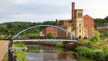
Millhouses's best nearby cities can be found at Sheffield, and Doncaster.
The area around Millhouses boasts some of the best shopping centres including Meadowhall, and Frenchgate Centre.
Doncaster Sheffield Airport is one of Millhouses's best, nearby airports to visit in Millhouses.
Millhouses History
There are some historic monuments around Millhouses:
- Two ring cairns at Ciceley Low, 500m ESE of Parson House Farm
- Abbeydale Works
- Roman Ridge: section 600yds (550m) long between Jenkin Lane (now Road) and Tylers Street
- Cairnfield, field system and ring cairn 1300m NNW of Newbridge Farm
- Cairnfield, linear clearance and ring cairn 720m north west of Moor Edge Farm
- Castle Hill motte and bailey castle
- Wayside cross west of Fox Lane
- Hoffman Kiln between Aizlewood Road and Cutts Terrace
- Stone circle on Ash Cabin Flat, 560m north east of Reservoir Cottages
- Cairn 500m west of Newbridge Farm
- Wayside cross in Shillito Wood
- The Shepherd Wheel
- Ring cairn and cairn on Ramsley Moor, 850m north east of Ramsley Lodge
- Waymarker and clapper bridge 130m south of Barbrook Bridge
- Cairnfield 400m north east of Ramsley Lodge
- Cairnfield and embanked stone circle 550m east of Barbrook Reservoir
- Bower Spring cementation furnace
- Cairnfield 860m north east of Ramsley Lodge
- Cairn 400m north west of Newbridge Farm
- Roman Ridge: section 180yds (160m) long on SE slopes of Wincobank Hill
- Lead smelting site on Bole Hill, west of Bolehill Lodge
- File factory, 11 High Street
- Manor Lodge
- Cairnfield, field system and ring cairn 650m east of Moorside Farm
- Former Sanderson's Darnall Steelworks and Don Valley Glassworks, Darnall Road
- Coke ovens, 120m north east of Summerley House
- Roman Ridge: section 400yds (370m) long from Hill Top Lane to Little Common Lane
- Wayside and boundary cross known as Lady's Cross
- Wincobank slight univallate hillfort and World War II anti-aircraft gun and searchlight emplacement
- Village settlement and barrows E of Gardom's Edge
- Cementation furnace, Hoyle Street
- Castle Hill motte and bailey castle, High Bradfield
- Lead mill on north bank of Bar Brook, 80m east of confluence with Sandyford Brook
- Lead smelting site on Ramsley Moor, 600m south west of Foxlane Farm
- Mousehole Forge, Malin Bridge
- Little Matlock rolling mill immediately south and east of Olive Terrace
- Cairnfield 320m north of Saltersitch Bridge, Eastern Moors
- Cairnfield 615m west of Moor Edge Farm
- Cairnfield 1400m north west of Clod Hall Farm
- Roman Ridge: SE of Hill Top (section 700yds (660m) long, Meadowhall Road to Hill Top)
- Prehistoric landscape on Big Moor and Ramsley Moor
- Standing cross at the Church of St Mary
- Holmesfield moated site and headland
- Cup and ring marked rock 740m east of Park Head House
- Romano-British field system and settlement at Wheata Wood
- Lead smelt mill in Linacre Wood, 160m east of Lower Linacre Reservoir dam
- Beauchief Abbey Premonstratensian monastery: inner precinct and three fishponds
- Standing cross at the Church of St James, Norton
- Cairn 1500m north west of Newbridge Farm
- Willow Garth moated site and fishpond, Ecclesfield
- Wayside cross west of Saltersitch Bridge
- Cairnfield 180m north east of Ramsley Lodge
- Wayside cross known as Whibbersley Cross
Places to see near Millhouses
Lakes near Millhouses
Canals near Millhouses
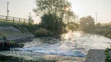
Rivers near Millhouses
- Kearsley Bk
- Porter from Source to River Sheaf
- Car Brook from Source to River Don
- Hooton Brook from Source to River Don
- Sheaf from Source to River Don
- Don from River Loxley confl to River Don Works
- Don from River Rother to River Dearne
- Greasbrough Dike from Source to River Don
- Blackburn Brook from Source to River Don
- Don from River Dearne to Mill Dyke
- Don from River Don Works to River Rother
- Hoyle Mill Stream from Source to River Went
- New Fleet Drain from source to R Went
- Went from Hoyle Mill Stream to Blowell Drain
- Frickley Beck from Source to Ea Beck
- Went from Source to Hoyle Mill Stream
- Ea Beck from the Skell to River Don
- Ea Beck from the Skell to River Don
- Ea Beck from Frickley Beck to the Skell
- Bentley Mill Stream
- Blowell Drain from Source to the Went
- Went from Blowell Drain to the River Don
- The Skell from Source to Ea Beck
- Womersley Beck from Source to Blowell Drain
- Don from Mill Dyke to River Ouse
- Swinefleet Warping Drain Source to River Ouse
- Ea Beck from Source to Frickley Beck
- Bramwith Drain from Source to River Don
- Dodworth Dyke from Source to River Dove
- Grimethorpe Dike from Source to River Dearne
- Silkstone Beck from Source to Cawthorne Dyke
- Dearne from Cawthorne Dyke to Lundwood STW
- Cudworth Dyke from Source to River Dearne
- Ings/Carr/Thurnscoe Dikes from Source to Dearne
- Bentley Brook from Source to River Dearne
- Dearne from Lundwood to River Dove
- Dearne from Bentley Brook to Cawthorne Dyke
- Rockley Dike from Source to River Dove
- Dearne from Source to Bentley Brook
- Dearne Darfield STW to River Don
- Cawthorne Dyke from Source to River Dearne
- Dove from Source to River Dearne
- Knoll Beck from Source to River Dearne
- Owler Beck from Source to River Calder
- Oakenshaw Beck from Source to River Calder
- Choke Churl Bk from Source to River Calder
- Chald from Source to River Calder
- Batley Beck from Source to River Calder
- Spen Beck from Source to River Calder
- Smithy Brook from Source to River Calder
- Calder from River Colne to River Chald
- Calder from River Chald to River Aire


