Brompton
Brompton is a Village in the county of Shropshire.
Brompton postcode: SY5 6LE
There are great places to visit near Brompton including some great towns, rivers and streams, castles, ruins, villages, historic buildings and shopping centres.
Brompton has some unmissable towns nearby like Clun, Shrewsbury, and Telford.
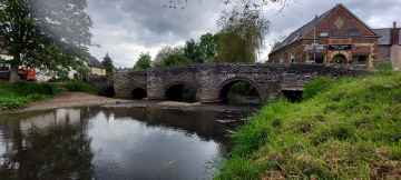
There are a number of rivers and streams near to Brompton including River Clun.
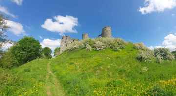
Clun Castle, and Acton Burnell Castle are some of Brompton best castles to visit near Brompton.
There are a number of ruins near Brompton including Clun Castle, and Acton Burnell Castle.
Places near Brompton feature a number of interesting villages including Acton Burnell.
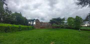
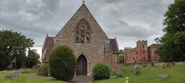
There are a several good historic buildings in the area around Brompton like Church of Saint Mary at Acton Burnell.
Telford Centre is a great place to visit close to Brompton if you like shopping centres.
Brompton History
There are some historic monuments around Brompton:
- Dovecote at Chirbury Hall Farm
- Bowl barrow on Hergan Hill, 530m north west of Myndtown
- Offa's Dyke: Cwm Section
- Pentre Camp
- Offa's Dyke: Section NE of Welshpool-Churchstoke Road
- Motte castle at the south end of East Dudston hamlet
- Offa's Dyke: Section from Road Junction near Drewin to County Boundary
- Offa's Dyke: section one mile 750yds (2290m) from Dudston Covert to a point 300yds (274m) N of Lack Brook Also in Powys: Wales
- Mound & Bailey Castle
- Offa's Dyke: Section W of Court House Farm
- Montgomery Medieval Town, Kerry Gate Extra Mural Settlement
- Motte and bailey castle 150m north east of Wilmington
- Offa's Dyke: Section from Cwm By-Road to Hem Road
- Offa's Dyke: section 1600yds (1460m) long, N from St John the Baptist's Church to River Unk
- Three Roman camps NW of Brompton Mill including tumulus and section of Offa's Dyke
- Bowl barrow 1km south east of Hopton Bank
- Hen Domen Pre-Conquest Fields
- Mount Pleasant Enclosure
- Offa's Dyke: section 430yds (390m) in length S of Chirbury-Montgomery road
- Cefn Llan Hillfort
- Motte castle 100m north of Wotherton Hall
- Site E of Plas-Llwyn (revealed by aerial photography)
- Calcot Camp
- Offa's Dyke: section 400m east of Cwm Farm
- Offa's Dyke: Section from point 90m S of Chirbury Road to S Boundary of Nant-Cribau Park
- Offa's Dyke: two sections running 400yds (370m) S of Camlad Stream Also in Powys: Wales
- Small enclosed settlement on Castle Idris, 400m south west of Penrhiew Lodge
- Henfron Moated Site
- Mellington Hill Round Barrow
- Hen Domen Mound & Bailey Castle
- Camp S of Old Hall Sarn
- Standing stone 350yds (320m) SE of Whitcott Keysett
- Caer-Din
- Corndon Hill Round Cairns
- Bowl barrow on Acton Bank, 170m north of Acton House
- Colstey Bank Iron Age enclosure
- Offa's Dyke: section NW of Ditches Farm Also in Powys: Wales
- Forden Gaer Roman Site
- Bishop's Moat Mound & Bailey Castle
- Simon's Castle
- Upper Short Ditch Also in Powys: Wales
- Offa's Dyke: Section from North Lodge, Leighton Park to Old Quarry S of Green Wood
- Motte castle adjacent to The Mount cottage
- Lower Min-y-Llyn Castle Mound
- Round Barrow on Saddle to E of Corndon Hill
- Nant-Cribau Castle Mound
- Dyffryn Lane Ring Ditches & Pit Alignments (Formerly Dyffryn Lane Round Barrow)
- Montgomery Castle
- The Lower Short Ditch
- Hyssington Mound & Bailey Castle
- Caer-Din Ring: a small enclosed Iron Age or Romano-British settlement, an adjacent ancient field boundary, round barrow and cultivation remains
- Upper Short Ditch
- Offa's Dyke: section 575m north west of Myndtown
- Offa's Dyke; Brompton Bridge section extending from Brompton Bridge to Mellington Hall Lodge
- Offa's Dyke: section 175m east of Cefn Bronydd
- Ringwork and cultivation remains 260m west of St Michael's Church
- Motte castle 400m north east of Upper Gwarthlow Farm
- Bicton motte and bailey castle
- Mitchell's Fold stone circle, standing stone and cairn 280m south west of Mitchell's Fold
- Nant-Cribau Moated House Site
- Offa's Dyke: section 400yds (370m) long S of Rownal Covert
- Wantyn Dyke
- Lower Short Ditch (Northern Part)
- Offa's Dyke: section 2/3 mile (1170m) long, N from southern boundary of Rownal Covert
- Upper Aldress Moated Site
- Small enclosed Iron Age or Romano-British settlement and adjacent cultivation remains, 450m north west of Cwm Farm
- Motte and bailey castle and line of Offa's Dyke adjacent to Brompton Mill
- Maen Beuno
- Offa's Dyke: Mellington Hall Section Extending from Mellington Hall Lodge to Lower Cwm
- Roundton Hillfort
- Small enclosed settlement in Knuck Wood
- Llwynderw Round Barrow
- Town Bank & Ditches
- Offa's Dyke: Section from Dudston Covert, Lymore to Lack Brook, Churchstoke
- Moated site and fishponds 250m south west of Middleton Farm
- Motte and bailey castle 80m south east of Hockleton Farm
- Montgomery Medieval Town, Part adjacent to Westmead, School Lane
- Offa's Dyke: section 430m north east of Middle Knuck Farm
- Ffridd Faldwyn Camp
- Small enclosed settlement on Fron, 340m west of St John's Church
- Caerbre
- Castle Ring: a large univallate hillfort, 600m south east of Meadowtown Farm
- Offa's Dyke: section 1/2 mile (800m) long, SE from county boundary to River Unk Also in Powys: Wales