Llanfaredd
Llanfaredd is a Village in the county of Powys.
Llanfaredd postcode: LD2 3UG
There are great places to visit near Llanfaredd including some great waterfalls, mountains, caves and ancient sites.
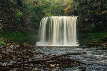
The area around Llanfaredd features a number of interesting waterfalls including Sgwd Yr Eira, Sgwd Isaf Clun Gwyn, Sgwd Y Pannwr, and Dan Yr Ogof Waterfalls.
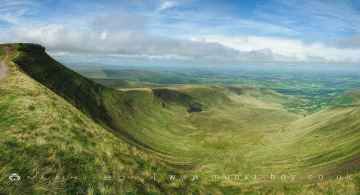
Llanfaredd has some unmissable mountains nearby like Corn Du, and Pen y Fan.
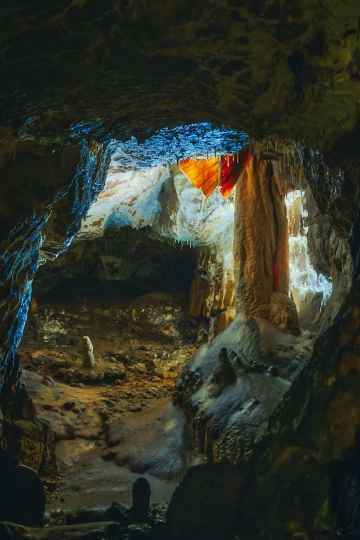
There are a number of caves near to Llanfaredd including Dan Yr Ogof.
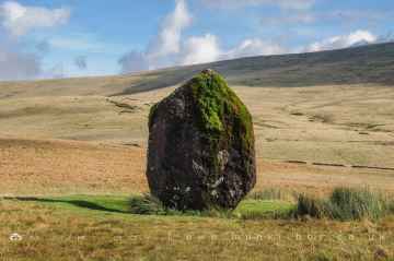
Ancient Sites to visit near Llanfaredd include Maen Llia Standing Stone.
Llanfaredd History
There are some historic monuments around Llanfaredd:
- Earthwork 100m N of Caer Du, Howey
- Aberedw Castle Mound
- Cefn Clawdd Cairn
- Gwenddwr Deserted Village
- Bongam Bank Round Barrows
- Gwernfach round cairn
- Cwm Berwyn Camp
- Cefn Corast Deserted Rural Settlement
- Castell Cae-Maerdy Castle Mound
- Pant Purlas Round Barrow
- Caer Du
- Aberedw Hill Deserted Rural Settlement
- Castle Mound 400m N of Cefnige
- Castle Bank ring cairn
- Bryntwppa stone row
- Blaenhenllan round cairn
- Caer Beris
- The Mount Mound & Bailey Castle, Hundred House
- Colwyn Castle
- Llanbedr Hill Cist Cairn
- Llandrindod Wells Roman road
- Cefn Wylfre Deserted Rural Settlement
- Carneddau round cairns
- The Gaer hillfort
- Two Cooking Mounds 350m W of Llwynceubren, Howey
- Castle Earthwork 200m S of Coed Caeau
- Ring Cairn on Waun Gunllwch
- Court stone row
- Fforest Wood Mound & Bailey Castle
- Upper House Platform House
- Ffrwd standing stone
- Castle Bank Hillfort
- Standing Stone E of Llangoed Wood
- Builth Castle
- Bank House Medieval Settlement
- Cilberllan ring cairn
- Cwmhindda Deserted Rural Settlement
- Broomy Hill, standing stone on S
- Llwyn-y-wrach standing stone
- Cwmbrith Round Cairn
- Broomy Hill, standing stone on N
- Gwaun Ymryson Round Cairn
- Coed Chwefri Vickers Machine Gun Emplacement
- Cefnllys Castle
- Carneddau Round Cairn
- Aberedw Castle
- Nant Brook Enclosure
- Carreg-Wiber Bank Earthwork
- Little Hill Round Barrows
- Roman Earthworks S of Llandrindod Wells
- Cefn Clawdd Cairn (East)
- Carneddau, round cairn on N end of
- Gelli Hill Round Barrow
- Broomy Hill standing stone
- Court standing stone
- Pawl Hir Ring Cairn
- Dol-y-Fan Round Cairn
- Twyn y Post Cairns
- Aberedw Hill Round Barrows
- Roman Fortlet (revealed by aerial photography), Disserth
- Cornelau Uchaf Enclosure
- Caer Einon Camp
- Cwmblaenerw Enclosed Long Hut
- Garnfawr Deserted Rural Settlement
- Gilwern Hill round cairn
- Hundred House round barrow
- Carneddau, cairn on N end of
- Pen-y-bont Standing Stone
- Cwm standing stone
- Cefnllys Medieval Settlement and Field Systems
- Cwmblaenerw House Platforms
- Twyn y Garth Round Barrows
- Penarth Mount Castle Mound
- Neuadd-Glan-Gwy Standing Stone
- Cwrt Llechryd moated site
- Banc y Celyn Stone Circle
- Gelli Hill Stone Circle
- Crickadarn Camp
- Pant y Rhiw Medieval Settlement
- Upper House round cairns
- Caer Fawr Medieval Settlement
- Graig Camp
- Hendy Long Hut
- Llandrindod Common Roman Practice Camps
- Gilwern Hill, round cairn on NE of
- Carneddau, standing stone to SSW of
- Cwm-berwyn round cairn
- Llwyn-Ceubren Round Barrow