Hyssington
Hyssington is a Village in the county of Powys.
Hyssington postcode: SY15 6AT
There are great places to visit near Hyssington including some great waterfalls, mountains, caves and ancient sites.
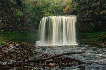
Waterfalls to visit near Hyssington include Sgwd Yr Eira, Dan Yr Ogof Waterfalls, Sgwd Isaf Clun Gwyn, and Sgwd Y Pannwr.
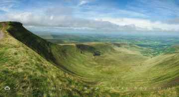
There are a several good mountains in the Hyssington area like Corn Du, and Pen y Fan.
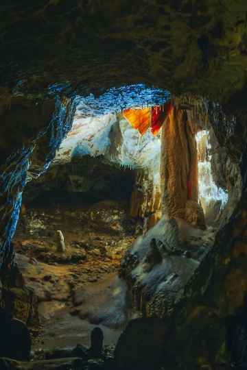
Don't miss Dan Yr Ogof's caves if visiting the area around Hyssington.
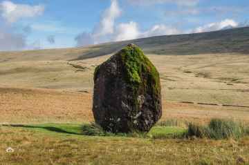
Don't miss Maen Llia Standing Stone's ancient sites if visiting the area around Hyssington.
Hyssington History
There are some historic monuments around Hyssington:
- Billings Ring large univallate hillfort
- Small enclosed settlement in Knuck Wood
- Offa's Dyke: Cwm Section
- Small enclosed Iron Age settlement at Leigh Wood, 180m south of Leigh Hall
- Ringwork and cultivation remains 260m west of St Michael's Church
- Hyssington Mound & Bailey Castle
- Moated site and fishponds 250m south west of Middleton Farm
- Hardwick castle motte and bailey castle 140m WSW of Hardwick Hall
- Roveries Hill Camp slight univallate hillfort 400m north east of The Roveries
- Round cairn south of Cranberry Rock, 460m north east of Bog Cottage
- Offa's Dyke: Section from Road Junction near Drewin to County Boundary
- Corndon Hill Round Cairns
- Three Roman camps NW of Brompton Mill including tumulus and section of Offa's Dyke
- Offa's Dyke: Mellington Hall Section Extending from Mellington Hall Lodge to Lower Cwm
- Upper Aldress Moated Site
- Offa's Dyke: section one mile 750yds (2290m) from Dudston Covert to a point 300yds (274m) N of Lack Brook Also in Powys: Wales
- Mellington Hill Round Barrow
- Offa's Dyke: Section from Dudston Covert, Lymore to Lack Brook, Churchstoke
- Round cairn on Stiperstones, 350m SSW of the Devil's Chair
- Dovecote at Chirbury Hall Farm
- Small enclosed Iron Age or Romano-British settlement and adjacent cultivation remains, 450m north west of Cwm Farm
- Motte and bailey castle and line of Offa's Dyke adjacent to Brompton Mill
- Calcot Camp
- Bowl barrow 390m south east of Stanley Cottage
- Castle Ring: a large univallate hillfort, 600m south east of Meadowtown Farm
- Linley Hill Camp
- Bowl barrow 320m south of Pitcholds
- Roundton Hillfort
- Roman villa at Linley Hall
- Mitchell's Fold stone circle, standing stone and cairn 280m south west of Mitchell's Fold
- Motte castle 400m north east of Upper Gwarthlow Farm
- Motte castle 100m south west of Lady House Farm
- Pentre Camp
- Tower keep castle at Lower Lea
- Snailbeach lead mine
- Offa's Dyke: section 175m east of Cefn Bronydd
- Bowl barrow on Round Hill, 200m west of The Napp
- Offa's Dyke: section 1/2 mile (800m) long, SE from county boundary to River Unk Also in Powys: Wales
- Snailbeach new smeltmill, 350m north east of Green Acres
- Offa's Dyke: section 400m east of Cwm Farm
- Offa's Dyke: section NW of Ditches Farm Also in Powys: Wales
- Moated site at Leigh Hall
- Roman Gravels lead mine
- Wagbeach adit portal, 630m and 640m south of Hogstow Mill
- Bury Ditches, a small multivallate hillfort on the summit of Sunnyhill
- Caerbre
- Motte and bailey castle with associated remains of a medieval village and ridge and furrow cultivation, 200m west of St Peter's Church
- Motte and bailey castle and bishops' palace
- Settlement remains of Blakemoorflat
- Motte castle 100m north of Wotherton Hall
- Engine house at Ladywell lead mine, 850m north west of Shelve Farm
- Motte and bailey castle 150m north east of Wilmington
- Bowl barrow on Acton Bank, 170m north of Acton House
- Caer-Din
- Hoarstone stone circle and two round cairns 400m north west of Holly Cottage
- Offa's Dyke: section 1600yds (1460m) long, N from St John the Baptist's Church to River Unk
- Motte and bailey castle 100m west of Holy Trinity Church
- Colstey Bank Iron Age enclosure
- Settlement remains of Blakemoorgate
- Bishop's Moat Mound & Bailey Castle
- Bowl barrow at The Napp
- Offa's Dyke: section 430m north east of Middle Knuck Farm
- Bowl barrow at Eaton Farm
- Offa's Dyke; Brompton Bridge section extending from Brompton Bridge to Mellington Hall Lodge
- Motte castle adjacent to The Mount cottage
- Simon's Castle
- Round cairn on Stiperstones, 150m south of Manstone Rock.
- Trelystan Church House Round Barrows
- Castle Ring: a large univallate hillfort on Oak Hill, 600m south east of Crows Nest Farm
- Motte and bailey castle 80m south east of Hockleton Farm
- Ritton Castle: a slight univallate hillfort and a ringwork and bailey castle
- Round barrow S of Linley Hall
- Bowl barrow on Hergan Hill, 530m north west of Myndtown
- Motte castle and associated settlement remains 150m NNW of Lower Down Farm
- Ringwork on Whitsburn Hill, 310m south west of Whitsburn Cottage
- Tor cairn on Stiperstones, 130m SSE of Manstone Rock.
- Slight univallate hillfort 600m north of Roveries House
- Tankerville lead mine
- Round Barrow on Saddle to E of Corndon Hill
- Motte castle at Colebatch, 100m north of Lagden
- Site S of Bagbury (revealed by aerial photography)
- Motte castle 50m north of Village Farm
- Offa's Dyke: section 575m north west of Myndtown
- Round cairn 38m NE of OS triangulation pillar on Manstone Rock