Cascob
Cascob is a Village in the county of Powys.
Cascob postcode: LD8 2NT
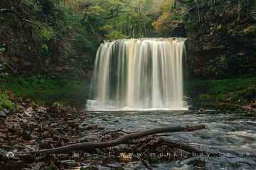
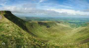
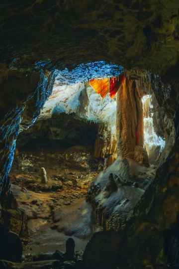
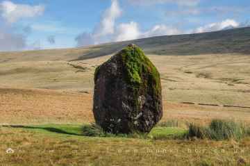
There are great places to visit near Cascob including some great waterfalls, mountains, caves and ancient sites.
There are a number of waterfalls near Cascob including Sgwd Yr Eira, Sgwd Isaf Clun Gwyn, Sgwd Y Pannwr, and Dan Yr Ogof Waterfalls.
Cascob's best nearby mountains can be found at Corn Du, and Pen y Fan.
Don't miss Dan Yr Ogof's caves if visiting the area around Cascob.
Maen Llia Standing Stone is a great place to visit close to Cascob if you like ancient sites.
Cascob History
There are some historic monuments around Cascob:
- Offa's Dyke: section 90m south of Brynorgan
- Roman Fort E of Hindwell Farm
- Gilwern Brook round barrow
- New Radnor Medieval Town: South West Quadrant
- Worsell Wood cairn cemetery
- Rhos-crug hut platform (E)
- Offa's Dyke: Section extending 2143m S from The Firs, Rhos-y-Meirch
- Glog Camp
- Three Roman Camps (revealed by aerial photography) NE of Walton
- Hindwell palisaded enclosure
- Barland Motte and Bailey
- Old Radnor Castle
- Black Mixen, round barrow to NW of
- Mound and Bailey Castle 495m NW of Ditch Hill Bridge
- Discoed Castle Mound
- Offa's Dyke: Section extending 200m S to Pool House, Rhos-y-Meirch
- Town Bank and Ditch
- The Four Stones
- Castell Foel-Allt
- Standing Stone 400m ENE of Four Stones
- Mynachdy Moated Enclosure
- Churchyard cross in St Mary the Virgin's churchyard
- Bowl barrow 160m north of Mellin-y-Grogue
- Offa's Dyke: Section extending 202m from River Teme to West Street
- Bryn y Castell
- Hindwell Farm Round Barrows
- Mound 150yds (140m) N of church
- Burfa Camp
- Castle Nimble
- Black Mixen round barrow
- Castle Twts
- Offa's Dyke: section 650m east of Cwm-sanaham
- Great Rhos round barrow
- Offa's Dyke: Rushock Hill section, extending 1630yds (1490m) E to Kennel Wood
- The Whimble Barrow
- Kinnerton Castle Mound
- Castle Ring
- Rhos-crug Hill settlement
- Beacon Hill Round Barrows
- Twiscob Moated Site
- Womaston Castle Mound
- Churchyard cross in St Michael's churchyard
- Mound & Bailey Castle 360m ESE of St Peter's Church
- Knighton Mound & Bailey Castle
- Offa's Dyke: section 400m north and 170m east of Selley Hall
- Offa's Dyke: section 890m north west and 320m west of Little Selley
- Two Round Barrows NE of Harpton Court
- Offa's Dyke: Section from Ditchyeld Bridge to County Boundary
- Round Barrow Near Pennant Pound
- Short Ditch near Beacon Lodge
- Bronze Age Round Barrows on Whinyard Rocks
- Offa's Dyke: Section extending through Great Ffrydd Wood 1693m S to footpath leading to Woodhouse Lane
- Radnor Castle
- Water-break-its-neck promontory fort
- Offa's Dyke: section 475m north east of Nether Skyborry
- Mound & Bailey Castle, Bleddfa
- Offa's Dyke: Section from Whitton-Presteigne Road to River Lugg
- Llanfihangel Hill round barrow
- Ednol Chapel
- Cnwclas Castle
- New Radnor: Interior of Medieval Town
- Offa's Dyke: Section extending 380m from Burfa
- Knapp Farm Mound
- Offa's Dyke: Section from Granner Wood to Burfa
- Offa's Dyke: Section extending 1125m SW to Gilfach Wood
- Bowl barrow 300m south of Skyborry
- Cae-Banal Castle Mound
- Red Hill Bronze Age Barrows
- Offa's Dyke: Section extending 165m S to Fildas Place and thence from Mill stream to Frydd Wood
- Norton Mound And Bailey Castle
- Offa's Dyke: section S of Riddings Brook on Herrock Hill
- Offa's Dyke: Section extending 1960m from Yew Tree Farm to Quarries NE of Granner Wood
- Cwm Bwch round barrow pair