Buttington
Buttington is a Village in the county of Powys.
Buttington postcode: SY21 8HA
There are great places to visit near Buttington including some great waterfalls, mountains, caves and ancient sites.
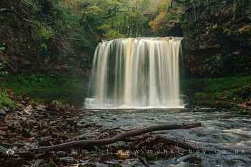
The area around Buttington boasts some of the best waterfalls including Sgwd Yr Eira, Dan Yr Ogof Waterfalls, Sgwd Isaf Clun Gwyn, and Sgwd Y Pannwr.
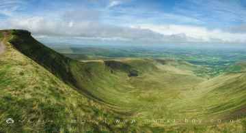
Mountains to visit near Buttington include Corn Du, and Pen y Fan.
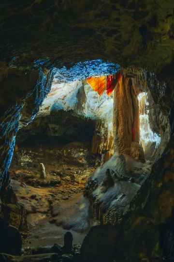
Dan Yr Ogof is a great place to visit close to Buttington if you like caves.
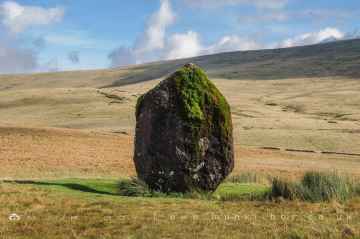
The area around Buttington's best ancient sites can be found at Maen Llia Standing Stone.
Buttington History
There are some historic monuments around Buttington:
- Black Bank Camp
- Motte and bailey castle 150m north east of Wilmington
- Small enclosed Iron Age settlement and a length of an adjacent hollow way, 350m north west of Beechfield
- Coed y Dinas Round Barrow
- Tan y Clawdd Camp
- Domen Castell Mound and Bailey Castle
- Lower Min-y-Llyn Castle Mound
- Collfryn Enclosure & Field System
- Dyffryn Lane Ring Ditches & Pit Alignments (Formerly Dyffryn Lane Round Barrow)
- Beacon Ring Camp (Caer Digoll)
- Offa's Dyke: Section NE of Welshpool-Churchstoke Road
- Cursus, Llwyn-Wron (revealed by aerial photography)
- Motte and bailey castle 80m south east of Hockleton Farm
- Maen Beuno
- Cefn y Castell
- Offa's Dyke: Section from Cwm By-Road to Hem Road
- Offa's Dyke: Section extending 760m N from centre of Goppas Wood to Hope By-Road
- Railway Transfer Dock at Welshpool
- Offa's Dyke: Section from North Lodge, Leighton Park to Old Quarry S of Green Wood
- Motte castle adjacent to The Mount cottage
- Crowther's Coppice Camp
- Gaer Fawr
- Offa's Dyke: Section W of Court House Farm
- Moated site and fishponds 250m south west of Middleton Farm
- Site E of Plas-Llwyn (revealed by aerial photography)
- Breiddin Hill Camp
- Nant-Cribau Castle Mound
- Rhysnant Hall Castle Mound
- Offa's Dyke: two sections running 400yds (370m) S of Camlad Stream Also in Powys: Wales
- Offa's Dyke: Sections extending 675m S from centre of Goppas Wood
- Mound & Bailey Castle
- Bryngwyn Wood Camp
- Camp & Fields on New Pieces, Breiddin Hill
- Llandrinio Bridge
- Nant-Cribau Moated House Site
- Mount in Powis Castle Park
- Plas yn Dinas
- Hen Domen Mound & Bailey Castle
- Offa's Dyke: section 2/3 mile (1170m) long, N from southern boundary of Rownal Covert
- Hen Domen
- Camp 350m NW of Varchoel Hall (revealed by aerial photography)
- Offa's Dyke: Section extending 3000m SE to Bele Brook, Llandrinio
- Powis Castle Park Mound
- Offa's Dyke: Pentre Section
- Offa's Dyke: Section at Pentre Farm
- Mitchell's Fold stone circle, standing stone and cairn 280m south west of Mitchell's Fold
- Knaps Barrows
- Llwynderw Round Barrow
- Strata Marcella Abbey
- Ringwork and cultivation remains 260m west of St Michael's Church
- Motte castle 100m north of Wotherton Hall
- Hen Domen Pre-Conquest Fields
- Trelystan Church House Round Barrows
- Round Barrow 225m SE of Clwyd-yr-onen
- Forden Gaer Roman Site
- Guilsfield Moated Site
- Dovecote at Chirbury Hall Farm
- Offa's Dyke: South of School House
- Castle Ring: a large univallate hillfort, 600m south east of Meadowtown Farm
- Two bowl barrows 290m north of Upper House Farm
- Offa's Dyke: Section from point 90m S of Chirbury Road to S Boundary of Nant-Cribau Park
- Bryn Mawr Camp