


Liss
Liss is a Town in the county of Hampshire.
There are great places to visit near Liss including some great cities, villages, lakes, towns, historic buildings, shopping centres and airports.
Liss's best nearby cities can be found at Portsmouth, and Winchester.
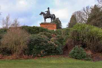
The area around Liss boasts some of the best villages including Southwick, and Milford-on-Sea.
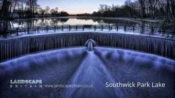
There are a several good lakes in the area around Liss like Southwick Park Lake.
There are a several good towns in the Liss area like Aldershot, Lymington, Gosport, Basingstoke, and Southampton.
Fort Blockhouse is a great place to visit close to Liss if you like historic buildings.
Shopping Centres to visit near Liss include The Malls - Basingstoke, and Westquay.
Airports to visit near Liss include Southampton Airport, and Blackbushe Airport.
Liss History
There are some historic monuments around Liss:
- Ruined church
- Deserted medieval village at Colemore
- Harting Beacon: a hilltop enclosure, Anglo-Saxon burial mound and telegraph station on Beacon and Pen Hills
- Medieval moated site in Parlour Copse
- Torberry hillfort
- Bowl barrow on Goldrings Warren
- Bowl barrow 250m north-west of Fitzhall Lodge: part of Fitzhall Heath round barrow cemetery
- Bofors Gun Emplacement at the former Bordon Camp
- Trotton Bridge
- Bowl barrow 100m south-east of Hogmoor Lodge
- Bell barrow 300m north east of the Club House on Petersfield Heath Common, part of the Petersfield Heath Group
- Two bowl barrows 380m south of Wenham Cottage: part of West Heath Common round barrow cemetery
- Bowl barrow 230m south east of the Club House on Petersfield Heath Common, part of the Petersfield Heath Group
- Round barrow cemetery 780m south west of Amherst House, Bordon Camp
- A deserted medieval village and post-medieval farm buildings, 1.4km north-west of Yew Tree Cottage
- Twin bowl barrow 660m east of the Club House on Petersfield Heath Common, part of the Petersfield Heath Group
- Walldown enclosures
- Saucer barrow 220m south of the Club House on Petersfield Heath Common, part of the Petersfield Heath Group
- Bowl barrow 220m WNW of Fitzhall Lodge: part of Fitzhall Heath round barrow cemetery
- Multiple cross dyke on Harting Downs, 570m east of Down Place
- Bell barrow 50m south of Gunsite
- Two bowl barrows 270m south of Oakhanger Road
- Bowl barrow and two saucer barrows 440m south east of the Club House on Petersfield Heath common, part of the Petersfield Heath Group
- Three bowl barrows on Trotton Common
- Two bowl barrows on Iping Common, 350m south west of Crowshole Farm
- Deserted medieval village
- Bowl barrow 280m WNW of Fitzhall Lodge: part of Fitzhall Heath round barrow cemetery
- Bowl barrow north west of Telegraph House
- Bowl barrow 400m south of Trottsford Farm
- Three bowl barrows on Ramsdean Down
- The Vandalian Tower, Up Park
- Durford Bridge
- Two bowl barrows 300m south east of the Club House on Petersfield Heath Common, part of the Petersfield Heath Group
- Bowl barrow on Weavers Down, 630m NNW of Allington Cottage
- Bowl barrow 180m north east of Foxcombe House
- Cross dyke on West Harting Down, 650m south west of Foxcombe Farm
- Selborne Priory
- Bowl barrow 50m south of Hogmoor Lodge
- Roman road at Chapel Common
- The Devil's Jumps round barrow cemetery
- Bowl barrow 490m south of the Club House on Petersfield Heath Common, part of the Petersfield Heath Group
- Earthwork on Farther Commons
- Medieval settlement at Hartley Mauditt
- Two bowl barrows 150m south east of the Club House on Petersfield Heath Common, part of the Petersfield Heath Group
- Hillfort on King John's Hill
- Disc barrow 460m south of the Club House on Petersfield Heath Common, part of the Petersfield Heath Group
- River Wey aqueduct, Headley Park
- Bowl barrow 240m east of the Club House on Petersfield Heath Common, part of the Petersfield Heath Group
- Romano-British and Iron Age buildings, field system and hollow ways in the southern part of Holt Down Plantation
- Three bowl barrows, 980m east of Woolmer Pond Cottage
- Hammer Wood hillfort
- Bowl barrow 820m ESE of Woolmer Pond Cottage
- Durford Abbey
- Bowl barrow on Treyford Hill
- Three disc barrows on Longmoor Common, 250m north west of the church
- Bowl barrow on Linch Down
- Mansio at Weston's Farm
- Romano-British village
- Roman earthworks on Stoner Hill, Ridge Hanger
- Two bowl barrows and a saucer barrow 360m south of the Club House on Petersfield Heath Common, part of the Petersfield Heath Group
- Bowl barrow 160m south of the Club House on Petersfield Heath Common, part of the Petersfield Heath Group
- A hilltop enclosed by Iron Age cross dykes, an associated field system and Bronze Age barrows at Butser Hill
- Disc barrow 310m east of the Club House on Petersfield Heath Common, part of the Petersfield Heath Group
- River Wey aqueduct, Bramshott Court
- Twin bowl barrow 325m south east of the Club House on Petersfield Heath Common, part of the Petersfield Heath Group
- Bowl barrow 520m north of Fitzhall: part of Fitzhall Heath round barrow cemetery
- River Wey aqueduct, Radford Bridge, Liphook
- Habin Bridge
- Bowl barrow on Weavers Down, 850m NNE of Wylds Farm
- Four bowl barrows on Weavers Down, 650m north west of The Sanctuary
- Bowl barrow on Long Down, 920m north east of Sewage Works at Longmoor Camp
- Bowl barrow 190m north east of the Club House on Petersfield Heath Common, part of the Petersfield Heath Group
- Bowl barrow on Didling Hill
- Round barrow cemetery, Roman road and hollow ways 200m south west of Woolmer Cottages
- Round barrow cemetery on Woolmer Down, 540m south of Woolmer Pond Cottage
- Three bowl barrows, 230m north of Sewage Works at Longmoor Camp
- Roman villa at Stroud, site near Petersfield
- Bowl barrow on Trotton Common, 500m south of Trotton Nurseries
Places to see near Liss


Lakes near Liss
Canals near Liss
Rivers near Liss
- Teffont
- Hampshire Avon (Upper) d/s Nine Mile River confl
- Nadder Trib (Swallowcliffe)
- Nadder (Middle)
- Linford Brook
- Hampshire Avon (Upper) u/s Nine Mile River confl
- Ripley Brook
- Ebble (Upper)
- Till (Hampshire Avon)
- Nadder (Headwaters)
- Clockhouse Stream
- Bisterne Stream
- Bourne (Hampshire Avon)
- Sem
- Ashford Water (Allen River)
- Etchilhampton Water
- Nine Mile River
- Wylye (Headwaters)
- Wylye (Middle)
- Wylye Trib (The Were or Swan)
- Ebble
- Ditchend Brook
- Hampshire Avon (West)
- Mude
- Chitterne Brook
- Nadder (Upper)
- Nadder (Lower)
- Sweatfords Water
- Wylye Trib (Heytesbury Stream)
- Hampshire Avon (East) and Woodborough Stream
- Huckles Brook
- Dockens Water
- Sleep Brook
- Hampshire Avon (Lower)
- Fonthill Stream
- Wylye (Lower)
- Hampshire Avon (East) and Deane Water
- Fovant Brook
- Penwood Stream
- Enborne (downstream A34 to Burghclere Brook)
- Lower Enborne
- Middle Kennet (Marlborough to Hungerford)
- Shalbourne (source to Kennet at Hungerford)
- Kingsclere Brook (Source to Enborne)
- Inkpen Stream (source to Kennet)
- Holy Brook
- Earlstone Stream and Burghclere Brook (source to Enborne)
- Winterbourne
- Froxfield Stream
- Clayhill Brook
- Enborne (Burghclere Brook to Kingsclere Brook)
- Upper Dun
- Og
- Kennet (Lambourn confluence to Enborne confluence)
- Kennet and Holy Brook
- Middle Kennet (Hungerford to Newbury)
- Upper Kennet to Marlborough
- Burghfield Brook
- Aldbourne
- Baughurst Brook
- West End Brook (tributary of Foudry Brook)
- Silchester Brook
- Lambourn (Source to Newbury)
- Enborne (Source to downstream A34)
- Foudry Brook (West End Brook to M4)
- Kennet and Avon Canal and Dun above Hungerford
- Ecchinswell Brook (source to Enborne)
- Vyne Stream
- Hart (Elvetham to Hartley Wintney)
- Cove Brook
- Whitewater
- Loddon (Swallowfield to River Thames confluence)
- Barkham Brook
- Loddon (Sherfield on Loddon to Swallowfield)
- Blackwater (Aldershot to Cove Brook confluence at Hawley)
- Blackwater (Bramshill to River Loddon confluence at Swallowfield)
- Emm Brook
- Blackwater (Hawley to Whitewater confluence at Bramshill)
- Fleet Brook
- Lyde
- Hart (Crondall to Elvetham)
- Bow Brook (Bramley to Sherfield Green)
- Twyford Brook
- Loddon (Basingstoke to River Lyde confluence at Hartley Wespall)
- Bow Brook (Pamber End to Bramley)
- Loddon (Hartley Wespall to Sherfield on Loddon)
- Domsey Brook
- Virley Brook
- Blackwater (Combined Essex)
- Pant
- Brain


