


Grateley
Grateley is a Town in the county of Hampshire.
There are great places to visit near Grateley including some great cities, towns, airports, villages, historic buildings, shopping centres and lakes.
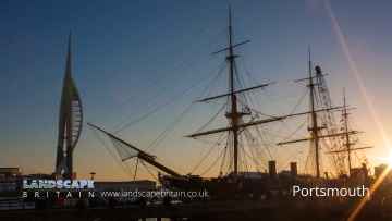
Grateley has some unmissable cities nearby like Portsmouth, and Winchester.
The area around Grateley features a number of interesting towns including Aldershot, Lymington, Gosport, Basingstoke, and Southampton.
Airports to visit near Grateley include Blackbushe Airport, and Southampton Airport.
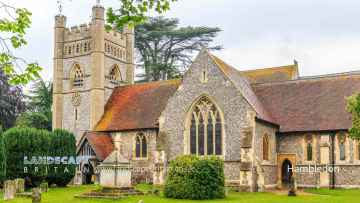
Hambledon, Southwick, and Milford-on-Sea are some of Grateley best villages to visit near Grateley.
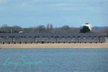
Grateley is near some unmissable historic buildings like Fort Blockhouse,
There are a number of shopping centres near Grateley including The Malls - Basingstoke, and Westquay.
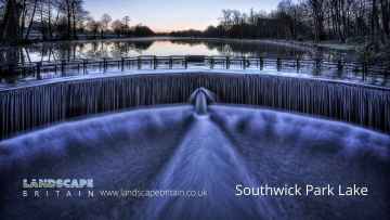
The area close to Grateley boasts some of the best lakes including Southwick Park Lake.
Grateley History
There are some historic monuments around Grateley:
- Long barrow 500m west of Croft Farm
- Sidbury Hill and associated monuments
- Bell barrow 250m NNE of the sports ground: one of a group of round barrows north west of Idmiston Down
- Section of Roman road by Upper and Lower Noad's Copse
- Wilbury House round barrow
- Bell barrow 300m ENE of the sports ground: one of a group of round barrows north west of Idmiston Down
- Seven Barrows: a barrow cemetery west of Clarendon Hill Reservoir
- Hydraulic pillbox on Middle Wallop Aerodrome
- Two bowl barrows 380m north east of Straight Walk Plantation: part of a group of round barrows south of Hampshire Gap
- Bowl barrow: one of a group of eight round barrows in Milston Down Wood
- Bowl barrow 125m north-east of South View Farm
- Bowl barrow: one of a group of eight round barrows in Milston Down Wood
- Two bowl barrows 90m south of Hill Lodge: part of a group of round barrows on Broughton Hill
- Three of a group of eight round barrows in Milston Down Wood
- Bell barrow, bowl barrow and section of hollow way 600m NNW of Long Orchard
- Bowl barrow 700m south east of Waters Down Farm
- Bowl barrow 535m SSW of the southern corner of Moll Harris's Clump: one of a group of round barrows on Porton Down
- Bowl barrow south-west of Sunnyhill Copse
- Bowl barrow south-east of Sidbury Hill
- Long barrow and two bowl barrows, 400m north of Chattis Hill House
- Iron Age fort in Ashley's Copse
- Bowl barrow: one of three round barrows south-west of Sun Plantation
- The Weather Hill multiperiod landscape and associated linear earthworks
- Bowl barrow 400m south of Waters Down Farm
- Barrows forming part of a cemetery, 320m north west of The Pheasant Hotel
- Long barrow: one of two long barrows east of Milston Down
- Bowl barrow 530m SSW of the southern corner of Moll Harris's Clump: one of a group of round barrows on Porton Down
- Long barrow and adjoining bowl barrow, 250m south of Martin's Clump
- Round barrow north-west of Halter's Hole
- Bowl barrow 20m south west of Hill Lodge: one of a group of round barrows on Broughton Hill
- Bowl barrow 370m east of Manor Farm: one of a group of round barrows on Porton Down
- Enclosure, probably unfinished, west of Sun Plantation
- Two of four round barrows on Hare Warren
- Round barrow cemetery 250m east of Straight Walk Plantation
- Boundary earthwork on Lamb Down
- Three round barrows 100m north west of Andover Lodge: part of a round barrow cemetery in Barrow Field Clumps, Cholderton Park
- Bronze Age enclosure and linear boundary earthwork on Boscombe Down East
- Round barrow cemetery in New Plantation 590m ESE of Amesbury Junction
- Bowl barrow: one of a dipsersed group of barrows on Beacon Hill/Bulford Down
- Bowl barrow 200m south west of Andover Lodge: part of a round barrow cemetery in Barrow Field Clumps, Cholderton Park
- Bowl barrow: one of four round barrows on Hare Warren
- Long barrow 50m north-east of Down Farm
- Ludgershall village cross
- Roman road immediately south east of Buckholt Farm
- Bronze Age enclosure and two bowl barrows 520m north east of Moll Harris's Clump on Idmiston Down
- Long barrow: one of two long barrows east of Milston Down
- Bowl barrow: one of three round barrows west of The Belt
- Iron Age hillfort in Ashley's Copse
- Round barrow east of Milston Down
- Bowl barrow 340m WSW of Andover Lodge: part of a round barrow cemetery in Barrow Field Clumps, Cholderton Park
- Bowl barrow in Windy Dido, 250m west of Horseshoe Meadow Farm
- Snail Down barrow cemetery and associated monuments.
- Beach Barrow
- Two bowl barrows 400m west of Easton Down Farm: part of a group of round barrows south of Easton Down
- Danebury Hill camp
- Long Barrow 350m south-east of Nutbane
- Foxcott deserted medieval village
- Bowl barrow 450m ENE of Manor Farm: one of a group of round barrows on Porton Down
- Two round barrows west of Hougoumont Farm
- Linear earthwork NW of Sidbury camp
- Boundary earthwork across Dunch Hill Golf Course
- Tithe barn, Roche Old Court
- A group of sixteen round barrows on Cow Down
- Three ditched bowl barrows south of Andover Lodge: part of a round barrow cemetery in Barrow Field Clumps, Cholderton Park
- Bowl barrow: one of three round barrows west of The Belt
- Bowl barrow 440m SSW of the southern corner of Moll Harris's Clump: one of a group of round barrows on Porton Down
- Bowl barrow 260m SSE of the southern corner of Moll Harris's Clump: one of a group of round barrows on Porton Down
- Enclosure on Everleigh Down, south-west of Snail Clump
- Roman earthwork
- Site of fortified manor
- Roman buildings on Lambourne's Hill
- Bowl barrow 680m SSE of the southern corner of Moll Harris's Clump: one of a group of round barrows on Porton Down
- Bowl barrow 260m SSW of Laundry Bungalows
- Quarley Hill camp
- Three bowl barrows 250m west of Andover Lodge: part of a round barrow cemetery in Barrow Field Clumps, Cholderton Park
- Bowl barrow 780m NNE of Hampshire Gap
- Bell barrow and bowl barrow 500m NNW of Long Orchard
- Boundary feature south of Clarendon Hill Reservoir
- Bowl barrow 130m WSW of Andover Lodge: part of a round barrow cemetery in Barrow Field Clumps, Cholderton Park
- Bowl barrow: one of four round barrows on Hare Warren
- Bowl barrow 90m west of Hill Lodge: one of a group of round barrows on Broughton Hill
- Long barrow 125m north-west of Waters Down Farm
- Bowl barrow 250m south of Martin's Clump
- Boundary earthwork running south from Dunch Hill, through Brigmerston Plantation and Milston Down.
- Saucer barrow 400m north east of the sports ground: one of a group of round barrows north west of Idmiston Down
- Bowl barrow 375m WNW of Easton Down Farm: part of a group of round barrows south of Easton Down
- Long barrow 350m south-west of Down Farm
- Deserted village (site of)
- Two disc barrows and two bowl barrows 900m north of Moll Harris's Clump on Idmiston Down
- Section of boundary earthwork east of Sidbury Hill
- Bowl barrow north east of Andover Plantation
- Bell barrow, three bowl barrows and gas testing trenches on Idmiston Down
- Bury Hill camp
- Bowl barrow 795m WSW of Franklin's Well
- Long barrow 450m south-west of Down Farm
- Bowl barrow 345m east of Old Rectory
- Two bowl barrows 265m south of the southern corner of Moll Harris's Clump: part of a group of round barrows on Porton Down
- Bowl barrow: one of three round barrows west of The Belt
- Devil's ditch: boundary earthwork
- Bowl barrow: one of a group of eight round barrows in Milston Down Wood
- Bowl barrow: one of a group of eight round barrows in Milston Down Wood
- Linear earthwork 500yds (460m) S of Sidbury camp
- Boundary earthwork and associated bowl barrow on Windmill Hill
- Roman villa 500yds (460m) SW of Clanville House
- Long barrow, Winterbourne
- Boundary earthwork across the Bulford Ranges
- Bowl barrow 750m NNE of Easton Down Farm
- Two bowl barrows 200m south of Laundry Bungalows
- Bowl barrow 250m south east of Tower Hill
- Barrow cemetery 730m north of Hampshire Gap
- Flint mines, linear boundary and two bowl barrows at Martin's Clump, Porton Down
- Bowl barrow: one of a group of eight round barrows in Milston Down Wood
- Bowl barrow 320m north east of Straight Walk Plantation: one of a group of round barrows south of Hampshire Gap
- Bowl barrow 650m ESE of Manor Farm: one of a group of round barrows on Porton Down
- Ludgershall Castle, a medieval ringwork and castle, Ludgershall
Places to see near Grateley
Lakes near Grateley
Canals near Grateley
Rivers near Grateley
- Teffont
- Hampshire Avon (Upper) d/s Nine Mile River confl
- Nadder Trib (Swallowcliffe)
- Nadder (Middle)
- Linford Brook
- Hampshire Avon (Upper) u/s Nine Mile River confl
- Ripley Brook
- Ebble (Upper)
- Till (Hampshire Avon)
- Nadder (Headwaters)
- Clockhouse Stream
- Bisterne Stream
- Bourne (Hampshire Avon)
- Sem
- Ashford Water (Allen River)
- Etchilhampton Water
- Nine Mile River
- Wylye (Headwaters)
- Wylye (Middle)
- Wylye Trib (The Were or Swan)
- Ebble
- Ditchend Brook
- Hampshire Avon (West)
- Mude
- Chitterne Brook
- Nadder (Upper)
- Nadder (Lower)
- Sweatfords Water
- Wylye Trib (Heytesbury Stream)
- Hampshire Avon (East) and Woodborough Stream
- Huckles Brook
- Dockens Water
- Sleep Brook
- Hampshire Avon (Lower)
- Fonthill Stream
- Wylye (Lower)
- Hampshire Avon (East) and Deane Water
- Fovant Brook
- Penwood Stream
- Enborne (downstream A34 to Burghclere Brook)
- Lower Enborne
- Middle Kennet (Marlborough to Hungerford)
- Shalbourne (source to Kennet at Hungerford)
- Kingsclere Brook (Source to Enborne)
- Inkpen Stream (source to Kennet)
- Holy Brook
- Earlstone Stream and Burghclere Brook (source to Enborne)
- Winterbourne
- Froxfield Stream
- Clayhill Brook
- Enborne (Burghclere Brook to Kingsclere Brook)
- Upper Dun
- Og
- Kennet (Lambourn confluence to Enborne confluence)
- Kennet and Holy Brook
- Middle Kennet (Hungerford to Newbury)
- Upper Kennet to Marlborough
- Burghfield Brook
- Aldbourne
- Baughurst Brook
- West End Brook (tributary of Foudry Brook)
- Silchester Brook
- Lambourn (Source to Newbury)
- Enborne (Source to downstream A34)
- Foudry Brook (West End Brook to M4)
- Kennet and Avon Canal and Dun above Hungerford
- Ecchinswell Brook (source to Enborne)
- Vyne Stream
- Hart (Elvetham to Hartley Wintney)
- Cove Brook
- Whitewater
- Loddon (Swallowfield to River Thames confluence)
- Barkham Brook
- Loddon (Sherfield on Loddon to Swallowfield)
- Blackwater (Aldershot to Cove Brook confluence at Hawley)
- Blackwater (Bramshill to River Loddon confluence at Swallowfield)
- Emm Brook
- Blackwater (Hawley to Whitewater confluence at Bramshill)
- Fleet Brook
- Lyde
- Hart (Crondall to Elvetham)
- Bow Brook (Bramley to Sherfield Green)
- Twyford Brook
- Loddon (Basingstoke to River Lyde confluence at Hartley Wespall)
- Bow Brook (Pamber End to Bramley)
- Loddon (Hartley Wespall to Sherfield on Loddon)
- Domsey Brook
- Virley Brook
- Blackwater (Combined Essex)
- Pant
- Brain


