


Damerham
Damerham is a Town in the county of Hampshire.
There are great places to visit near Damerham including some great cities, villages, lakes, towns, historic buildings, shopping centres and airports.
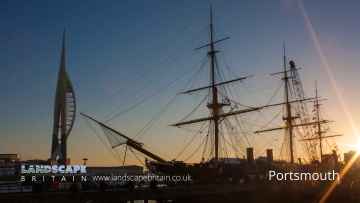
Damerham has some unmissable cities nearby like Portsmouth, and Winchester.
Southwick, and Milford-on-Sea are great places to visit near Damerham if you like villages.
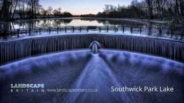
Southwick Park Lake is one of Damerham's best, nearby lakes to visit in Damerham.
Towns to visit near Damerham include Aldershot, Lymington, Gosport, Basingstoke, and Southampton.
Don't miss Fort Blockhouse's historic buildings if visiting the area around Damerham.
There are a number of shopping centres near Damerham including The Malls - Basingstoke, and Westquay.
Damerham has some unmissable airports nearby like Southampton Airport, and Blackbushe Airport.
Damerham History
There are some historic monuments around Damerham:
- Castle mound (or Castle Hill)
- Giant's Grave: a long barrow 400m north-west of Down Farm
- Packhorse bridge
- Earthworks S of Knighton Hill Buildings
- Long barrow 600yds (550m) SE of Vanity
- Long barrow south-west of Vernditch Chase
- Bowl barrow 210m north east of the junction of Grim's Ditch and Bokerley Dyke on Blagdon Hill
- Three associated linear earthworks on Martin Down
- Bowl barrow 270m north of Grim's Ditch, near Tidpit Common
- Sandalholme pottery works
- Long barrow on Little Toyd Down, 760m south west of Grims Lodge Farm
- Grim's Ditch: Old Lodge Copse to Toyd Clump
- A linear earthwork north east of West Woodyates Manor: part of the `Bokerley Line'
- Boundary banks on Rye Hill and in Maldry Wood
- Two sections of a linear earthwork north of West Woodyates Manor: part of the `Bokerley Line'
- Knighton Hill round barrow
- Stephen's Castle, a bowl barrow 720m east of Eastworth Farm
- Knoll Camp hillfort, cross dyke, linear earthwork and hollow ways near Damerham Knoll
- Bowl barrow 290m north east of the junction of Bokerley Dyke and a linear earthwork on Martin Down
- Bowl barrow 520m south of Ordnance Survey triangulation pillar in Ringwood Forest
- Bowl barrow on Ashley Heath, 510m south east of Duncombe Lodge
- Two bowl barrows in Plumley Wood, 1020m and 1060m south east of decoy pond, on Cranborne Common
- Ring ditch on Blackheath Down 650m south west of North Allenford Farm
- Barrows in and near St Giles Park
- Three adjoining linear earthworks and three bowl barrows north of Bokerley Dyke on Martin Down
- Grim's Ditch
- Soldier's Ring
- Field system on Stoke Down
- Clearbury Ring
- Bronze Age and Romano-British enclosure on Martin Down, east of Bokerley Junction
- Roman road along the south side of Vernditch Chase: part of the Roman road between Sorviodunum (Old Sarum) and Vindocladia (Badbury)
- Bowl barrow on Redman's Hill 450m south west of Bridge Farm
- Camp at Nine Yews
- Faulston pigeon house
- Bowl barrow 240m north east of Martin's Farm Bungalow
- Bowl barrow on the eastern part of Ashley Heath, 660m north west of Ashley Lodge
- Rockbourne Roman villa
- Two linear earthworks, two barrows and Iron Age and Romano-British settlements on Tidpit Common Down
- Bokerley Dyke, and a section of Grim's Ditch, a section of a medieval boundary bank, and two bowl barrows on and north west of Martin Down
- Bowl barrow 120m north east of the junction of Grim's Ditch and Bokerley Dyke on Blagdon Hill
- Knap barrow: a long barrow 900m west of Down Farm
- Bowl barrow 520m north east of the shoulder angle of Bokerley Dyke on Martin Down
- Medieval manorial buildings (uninhabited parts)
- Bowl barrow cemetery and a cross dyke on Horton Common 800m south of Bridge Farm
- Barrows in Salisbury Plantation
- Part of Dorset Cursus
- Bury Orchard ditch
- Potteries at Prairie Farm
- Bowl barrow on Pistle Down, 800m north east of Burrows Farm
- Bowl barrow 330m north of Grim's Ditch, near Tidpit Common
- Clearbury Down round barrow
- Bowl barrow 90m north east of Monmouth's Ash Farm
- Two bowl barrows 200m north of Grim's Ditch, near Tidpit Common
- Bowl barrow 250m north east of Monmouth's Ash Farm
- Bowl barrow on Homington Down, 725m south of Tottens Farm
- Four bowl barrows 865m north east of Squirrel's Corner
- Two linear earthworks in Vernditch Chase
- Long barrows and group of round barrows on Bokerly Down
- Bowl barrow on Mount Ararat, 550m east of Burrows Farm
- Two bowl barrows in Plumley Wood, 800m and 850m south of decoy pond, on Cranborne Common
- Roman road north east of Vernditch Chase: part of the Roman road between Sorviodunum (Old Sarum) and Vindocladia (Badbury)
- Long barrow 700m north-west of Tenantry Farm
- Duck's Nest: a long barrow on Rockbourne Down
- Celtic fields on Pentridge Down
- St Michael's Priory
- Long Barrow 800m north-west of Paradise
- Grans barrow: a long barrow 880m west of Down Farm
- Round barrow 860yds (786m) SE of Knighton Hill Buildings
- Barrow W of village
- Long barrow 700m west of Bride's Farm
- Rockbourne Down, Spring Pond enclosure
- Vernditch Chase long barrow
- Croucheston Down Barn round barrow
- Bowl barrow in Plumley Wood, 630m east of decoy pond, on Cranborne Common
- Fordingbridge Bridge
- Round barrow cemetery and two associated enclosures, 550m west of Wimborne Lodge, associated with the Knowlton Circles
- Bowl barrow 45m south west of Bowldish Pond
- Barrows N of St Giles Park
- Penbury Knoll camp on Pentridge Hill
- Long barrow in Round Clump
- Barrow on Pentridge Down
- Bowl barrow 350m east of the shoulder angle of Bokerley Dyke on Martin Down
- Two bowl barrows in Watchmoor Wood 270m and 290m south west of Ashley Lodge
- Round barrow cemetery south of New Barn Farm, associated with the Knowlton Circles
- Bowl barrow on Little Toyd Down, 650m south west of Grims Lodge Farm
- Barrow 30yds (27m) E of Dorset Cursus
- Odstock Copse earthwork
- Marleycombe Hill earthworks
- Length of deer park bank and ditch at Alderholt
- A linear earthwork and two bowl barrows east of Bokerley Dyke on Blagdon Hill
- Knowle Hill round barrow
- Knighton Roman road (stretching from Reddish Gore to reservoir)
- Wick Down round barrow
- The Giant's Grave long barrow
- Two round barrows S of Cranborne Farm
- Knighton Hill earthwork
- Bowl barrow 90m south west of Reservoir Cottage
- Mizmaze on Breamore Down
- Bowl barrow 620m south of Ordnance Survey triangulation pillar in Ringwood Forest
- Oval barrow on Pistle Down, 1010m north east of Stephen's Castle
- Long barrow 3/4 mile (1200m) SW of St Rumbold's Church
- Two bowl barrows on Mount Ararat, 865m and 910m north east of Stephen's Castle
- Whitsbury hillfort
- Bowl barrow 230m north east of Ebblake Bridge
- Two bowl barrows 445m south-west of Ordnance Survey triangulation pillar in Ringwood Forest
Places to see near Damerham

Lakes near Damerham
Canals near Damerham
Rivers near Damerham
- Teffont
- Hampshire Avon (Upper) d/s Nine Mile River confl
- Nadder Trib (Swallowcliffe)
- Nadder (Middle)
- Linford Brook
- Hampshire Avon (Upper) u/s Nine Mile River confl
- Ripley Brook
- Ebble (Upper)
- Till (Hampshire Avon)
- Nadder (Headwaters)
- Clockhouse Stream
- Bisterne Stream
- Bourne (Hampshire Avon)
- Sem
- Ashford Water (Allen River)
- Etchilhampton Water
- Nine Mile River
- Wylye (Headwaters)
- Wylye (Middle)
- Wylye Trib (The Were or Swan)
- Ebble
- Ditchend Brook
- Hampshire Avon (West)
- Mude
- Chitterne Brook
- Nadder (Upper)
- Nadder (Lower)
- Sweatfords Water
- Wylye Trib (Heytesbury Stream)
- Hampshire Avon (East) and Woodborough Stream
- Huckles Brook
- Dockens Water
- Sleep Brook
- Hampshire Avon (Lower)
- Fonthill Stream
- Wylye (Lower)
- Hampshire Avon (East) and Deane Water
- Fovant Brook
- Penwood Stream
- Enborne (downstream A34 to Burghclere Brook)
- Lower Enborne
- Middle Kennet (Marlborough to Hungerford)
- Shalbourne (source to Kennet at Hungerford)
- Kingsclere Brook (Source to Enborne)
- Inkpen Stream (source to Kennet)
- Holy Brook
- Earlstone Stream and Burghclere Brook (source to Enborne)
- Winterbourne
- Froxfield Stream
- Clayhill Brook
- Enborne (Burghclere Brook to Kingsclere Brook)
- Upper Dun
- Og
- Kennet (Lambourn confluence to Enborne confluence)
- Kennet and Holy Brook
- Middle Kennet (Hungerford to Newbury)
- Upper Kennet to Marlborough
- Burghfield Brook
- Aldbourne
- Baughurst Brook
- West End Brook (tributary of Foudry Brook)
- Silchester Brook
- Lambourn (Source to Newbury)
- Enborne (Source to downstream A34)
- Foudry Brook (West End Brook to M4)
- Kennet and Avon Canal and Dun above Hungerford
- Ecchinswell Brook (source to Enborne)
- Vyne Stream
- Hart (Elvetham to Hartley Wintney)
- Cove Brook
- Whitewater
- Loddon (Swallowfield to River Thames confluence)
- Barkham Brook
- Loddon (Sherfield on Loddon to Swallowfield)
- Blackwater (Aldershot to Cove Brook confluence at Hawley)
- Blackwater (Bramshill to River Loddon confluence at Swallowfield)
- Emm Brook
- Blackwater (Hawley to Whitewater confluence at Bramshill)
- Fleet Brook
- Lyde
- Hart (Crondall to Elvetham)
- Bow Brook (Bramley to Sherfield Green)
- Twyford Brook
- Loddon (Basingstoke to River Lyde confluence at Hartley Wespall)
- Bow Brook (Pamber End to Bramley)
- Loddon (Hartley Wespall to Sherfield on Loddon)
- Domsey Brook
- Virley Brook
- Blackwater (Combined Essex)
- Pant
- Brain


