


Bowes
Bowes is a Village in the county of County Durham.
There are great places to visit near Bowes including some great waterfalls, towns, country parks and airports.
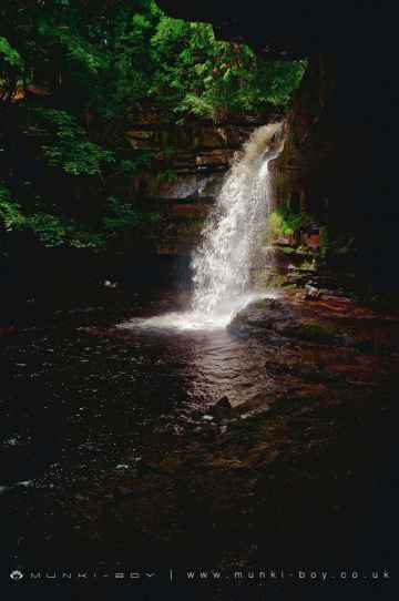
Summerhill Force is one of Bowes's best, nearby waterfalls to visit in Bowes.
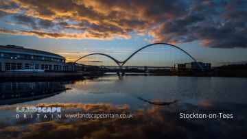
The area around Bowes boasts some of the best towns including Stockton-on-Tees, and Middleton-in-Teesdale.
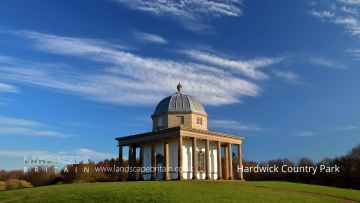
Hardwick Country Park is one of Bowes's best, nearby country parks to visit in Bowes.
Teesside International Airport is a great place to visit close to Bowes if you like airports.
Bowes History
There are some historic monuments around Bowes:
- A rock with a cup and a groove, in the south west corner of Scale Knoll Allotment, 790m south east of Far East Hope, Barningham Moor
- Barnard Castle: ringwork, shell keep castle, chapel and dovecote
- The Christening Stone, 160m east of Doe Park
- Cup marked rock 100m north of West Loups's, Cotherstone Moor
- How Tallon round barrow and cup marked stones
- Cup marked rocks and cairnfield at Bracken Heads, 380m north east of Folly Head
- A carved rock with at least 12 cups, 560m north of Brier Dykes, Baldersdale
- Scargill fortified house, medieval settlement and associated field system
- Prehistoric enclosure on the west side of Scale Knoll Gill, 400m WSW of Haythwaite, Barningham Moor
- Barnard Castle Bridge
- Cairn south of Cross Gill, 645m south east of Black Hill Gate, Barningham Moor
- Cairnfield partly enclosed by a bank, on the east side of Woodclose Gill, Scale Knoll Allotment, Barningham Moor, 550m south of Hurst Hill
- Cup and groove marked rock 450m WNW of Howgill Grange, Baldersdale
- A cup marked rock with 13 cups and a groove, on a knoll in Scale Knoll Allotment, 700m north east of Black Hill Gate, Barningham Moor
- Cairnfield on Ravock, 880m north west of Rovegill House
- A carved rock between The Stang Forest boundary wall and Woodclose Gill, 750m south east of Far East Hope, Barningham Moor
- A rock with cups and rings in Scale Knoll Allotment, 790m WSW of Haythwaite, Barningham Moor
- A cairn and a rubble bank in Scale Knoll Allotment, 510m WSW of Haythwaite, Barningham Moor
- Cairnfield on the north east slope of Ravock, Bowes Moor
- Cup ring and groove marked rock outcrop at Toby Wall, 260m north east of West Loups's, Cotherstone Moor
- Cup and ring marked rock on Goldsborough Rigg, Cotherstone Moor, 860m south east of Pitcher House
- Carved rock, cist and cairnfield 580m west of Hindon Edge
- Roman aqueduct, prehistoric field systems, cairnfield, enclosure and round cairn on Ravock
- A cairn on a knoll east of Woodclose Gill, in Scale Knoll Allotment, 785m north east of Black Hill Gate
- Four carved rocks on Blake Hill, 520m NNW of Hill Gill Farm, Baldersdale
- Four areas of carving on a rock outcrop 200m south west of The Rigg
- A cairn and a carved rock west of Cowclose Gill, in Scale Knoll Allotment, 460m west of Haythwaite, Barningham Moor
- Cup and groove marked rock 590m north of Brier Dykes, Baldersdale
- Cup and groove marked rock on Goldsborough Rigg, Cotherstone Moor, 920m south east of Pitcher House
- The Blakethwaite Dams
- A cairn, a carved rock, and a rubble bank, in the south west corner of Scale Knoll Allotment, 800m south east of Far East Hope, Barningham Moor
- Carved rock with one cup and four grooves 260m south west of The Rigg
- Cairnfield on Ravock, 600m south east of Ravock Castle, Bowes Moor
- Late prehistoric ditched, scarp-edge settlement 400m south-south-west of East Mellwaters farmhouse
- Medieval chapel 350m south east of Castle Farm
- Carved rocks in Stobgreen Plantation
- Rock with one cup on Goldsborough Rigg, Cotherstone Moor, 860m north west of West Loups's
- Roman shrine on Scargill Moor
- Cup marked rock on the summit of the hill, 420m west of Howgill Grange
- A prehistoric carved rock with four cups 620m north of Brier Dykes, Baldersdale
- A cairn, east of Scale Knoll Allotment, 260m south west of Haythwaite, Barningham Moor
- Cotherstone Castle
- Cup and ring marked rock 80m south of West Loups's, Cotherstone Moor
- A cup and groove marked rock, east of Woodclose Gill, 645m north east of Black Hill Gate, Barningham Moor
- Deepdale Bridge
- Roman signal station 190m north west of Vale House Farm
- A cairn on the summit of a knoll, in the southwest corner of Scale Knoll Allotment,800m south east of Far East Hope, Barningham Moor
- Prehistoric enclosure 530m and a rubble bank 500m east of Haythwaite in Scale Knoll Allotment, Barningham Moor
- Carved bedrock with cups and grooves 170m south east of The Rigg
- Cup, ring and groove marked rock 310m west of East Loups's, Cotherstone Moor
- Bowes Castle
- Cup and ring marked rock on Goldsborough Rigg, Cotherstone Moor, 870m south south east of Pitcher House
- Cairn near the summit of a low ridge, 850m south west of Cocker Stake Nook, Hope Moor
- Three prehistoric carved rocks on Goldsborough Rigg, Cotherstone Moor, 860m SSE Pitcher House
- A carved rock with one cup, at the east side of Woodclose Gill, in Scale Knoll Allotment, 500m north east of Black Hill Gate, Barningham Moor
- Carved rock in West Pasture 385m south west of The Rigg
- Carved rock and prehistoric enclosure on west side of Scale Knoll Gill, 410m south west of Haythwaite, Barningham Moor
- Roman Fort (Lavatrae)
- Cup and ring marked rock on Cotherstone Moor 520m north west of East Loups's
- Cairn on a prominent knoll and cairnfield to its south east on Ravock, Bowes Moor
- Prehistoric defended settlement 500m north west of West Holme House
- Cup and ring marked rock 130m south west of West Loups's, Cotherstone Moor
- A rock with three grooves and five cups with rings, in Scale Knoll Allotment, 800m WSW of Haythwaite, Barningham Moor
- Ring cairn on Goldsborough, Cotherstone Moor, 840m south of Pitcher House
- Area of carved bedrock 120m south of The Rigg
- Three cairns on Ravock, Bowes Moor, 830m north east of Ravock Castle
- Arkle Beck stone circle
- Cup, ring and groove marked rock on Kearton Rigg, 430m south of West Loups's, Cotherstone Moor
- Ring cairn at the northern end of Scale Knoll Allotment, 750m WNW of Haythwaite
- Cairn on the north side of Ravock, Bowes Moor, 600m west of West Stoney Keld
- A palisaded hilltop enclosure, a carved rock and a small enclosure, 480m north west of Brier Dykes, Baldersdale
- A Roman period native settlement, prehistoric carved rock and an iron smelting site on Knott Hill, 750m south of Stone Cross
- Cairn at West Moor Bottom, Mudbeck
- Ring cairn and adjacent round cairn on Low Moor, 460m NNW of High Eskeleth
- Two carved rocks east of West Pasture, 335m south west of The Rigg
- Cup marked rock outcrop at the base of a wall 120m east of East Loups's, Cotherstone Moor
- Prehistoric settlement and associated remains including carved rocks and a stone circle 400m north west of How Tallon Cairn, Barningham Moor
- Late prehistoric walled settlement 200m south-south-east of East Mellwaters farmhouse
- Two adjacent ring cairns on Low Moor, 310m north west of High Eskeleth
- Romano-British settlement site to the east and south-east of East Mellwaters farmhouse
- Medieval farmstead and two prehistoric carved rocks at West Loup's
- Cup, ring and groove marked rock 170m south west of West Loups's, Cotherstone Moor
- Carved rocks, cairnfield and rubble banks on the terrace south of Scale Knoll Allotment, immediately east of Black Hill Gate, Barningham Moor
- A carved rock and boulder walling, near the south wall of Scale Knoll Allotment, 500m north east of Black Hill Gate
- A cairn and a carved rock on a prominent knoll, south of the road from Barningham to East Hope, 690m WSW of Haythwaite, Barningham Moor
- Cairn on a low ridge on the east side of Ravock, Bowes Moor, 860m west south west of West Stoney Keld
- Cairn on the summit of Arndale Hill, Hope Moor
- Cup and groove marked rock on the south bank of Scaletree Gill, 560m north west of Park House Farm, Baldersdale
- Carved rock north of Washbeck Green, 570m south of Haythwaite, Barningham Moor
- Rock with many cup marks on the east bank of How Beck, 450m north west of West Loups's, Cotherstone Moor
Places to see near Bowes
Lakes near Bowes
Rivers near Bowes
- Croxdale Beck from Source to Wear
- Old Durham Beck from Source to Pittington Beck
- Twizell Burn from Source to Cong Burn
- Valley Burn from Source to Wear
- Blackdene Burn to confluence with Wear
- Pittington Beck from Coalford to Old Durham Beck
- Brancepeth Beck from Source to Wear
- South Burn to confluence with Wear
- Hendon Coastal Area
- Cong Burn from Source to Twizell Burn
- Old Durham Beck from Chapman Beck to Wear
- Cong Burn from Twizell Burn to Wear
- Lumley Park Burn from Source to Herrington Burn
- Wear DS of Lumley Park Burn to Tidal Limit
- Lumley Park Burn from Herrington Burn to R Wear
- Wear from Gaunless to Browney
- Wear from Croxdale Beck to Lumley Park Burn
- Herrington Burn from Source to Lumley Park Burn
- Deerness from Source to Hedleyhope Burn
- Browney from Source to Pan Burn
- Smallhope Burn from Source to Browney, Stocke
- Deerness from Hedleyhope Burn to Browney
- Browney from Pan Burn to Smallhope Burn
- Browney from Deerness confl to Wear
- Pan Burn Catchment (Trib of River Browney)
- Hedleyhope Burn from Source to Deerness
- Browney from Smallhope Burn Deerness confl
- Westernhope Burn from Source to Wear
- Ireshope Burn
- Wear from Middlehope Burn to Houselop Beck
- Swinhope Burn from Source to Wear
- Kilhope Burn from Source to Wear
- Burnhope Burn from Source to Wear
- Wear from Wearhead to Middlehope Burn, Iresho
- Stanhope Burn from Source to Wear
- Waskerley Beck from Source to Wear
- Middlehope Burn from Source to Wear
- Rookhope Burn from Source to Wear
- Bollihope Burn from Source to Wear
- Crimdon Beck from Source to Sea
- Hawthorn Burn from Source to North Sea
- Dalton Beck to North Sea
- Castle Eden Burn from Source to North Sea
- Castle Eden Burn from Source to North Sea
- Gaunless from Source to Hummer Beck
- Hummer Beck from Source to Gaunless
- Gaunless from Hummer Beck to Wear
- Wear from Beechburn Beck to Gaunless
- Wear from Houselop Beck to Beechburn Beck
- Bedburn Beck from Source to Euden Beck
- Houselop Beck from Source to Wear
- Beechburn Beck (Trib of Wear)
- Euden Beck Catchment (Trib of Bedburn Beck)
- South Grain Beck from Source to Bedburn Beck
- Linburn Beck from Source to Wear
- Harthorpe Beck (Trib of Bedburn Beck)
- Bedburn Beck from Euden Beck to Wear
- Horsleyhope Burn Catchment (Trib of Derwent)
- Nookton Burn from Source to River Derwent
- Pont Burn Catchment (trib of Derwent)
- Derwent from Nookton Burn to Burnhope Burn
- Derwent from Source to Nookton Burn
- Derwent from Burnhope Burn to River Tyne
- Burnhope Burn from Source to River Derwent
- Don from Source to Tidal Limit
- New Burn (Trib of Tyne)
- Blaydon Burn
- Ouse Burn from Source to Tyne
- Brierdene Burn from Source to North Sea
- Wallsend Burn (Trib of Tyne)
- Team from Source to Tyne
- Devils Water from Rowley Burn to Tyne
- Stocksfield Burn Catchment (trib of Tyne)
- March Burn Catchment (trib of Tyne)
- Red Burn (Trib of Tyne)
- Horsley to Throckley Area (Tyne N Bank)
- Tyne from Watersmeet to Tidal Limit
- Rowley Burn Catchment (Trib of Devils Water)
- Cor Burn Catchment (Trib of Tyne)
- West Dipton Burn from Source to Devil's Water
- Devils Water from Source to Rowley Burn
- Stanley Burn Catchment (trib of Tyne)
- Whittle Burn Catchment (trib of Tyne)
- Woodham Burn from Source to Rushyford beck
- Skerne form Woodham Burn to Demons Beck
- Upper Cocker Beck Catchment (trib of Skerne)
- Skerne from Carrs to Woodham Burn
- Skerne from Demons Beck to Tees
- Woodham Burn from Rushyford Beck to the Skerne
- Skerne from Source to Carrs
- Dene Beck Catchment (trib of Skerne)
- Carrs from Source to Skerne
- Rushyford Beck from Source to Woodham Burn
- Greta from Source to Sleightholme Beck
- Sleightholme Beck from Source to Greta
- Clow Beck from Barton Beck to Tees
- Greta from Sleightholme Beck to Eller Beck
- Tees from Percy Beck to River Greta
- Barton Beck from Source to Clow Beck
- Piercebridge Beck from Source to Tees
- Percy Beck Catchment (Trib of Tees)
- Greta from Eller Beck to Gill Beck
- Sudburn Beck from Source to Langley Beck
- Tees from River Greta to River Skerne
- Greta from Gill Beck to River Tees
- Deepdale Beck from Source to River Tees
- Langley Beck from Source to Sudburn Beck
- Aldbrough Beck from Source to Clow Beck
- Eller Beck from Source to River Greta
- Aldbrough Beck from Forcett Park Catch to Clow Bk
- Langley Bk and Westholme Bk frm Sudburn Bk to Tees
- Mary Wild Beck from Source to Clow Beck
- Gill Beck from Source to Greta
- Nidd from Ashfoldside Beck to Birstwith
- Nidd from Howstean Beck to Ashfoldside Beck
- Howstean Beck from Source to River Nidd
- Nidd from Source to Howstean Beck
- Ashfoldside Beck to River Nidd
- Darley Beck Catchment (Trib of Nidd)
- Fell Beck/Far Beck Catch (Trib of Nidd)
- Nidd from Oak Beck to Low Bridge on Briggate (Knaresborough)
- Crimple Beck from Park Beck to River Nidd
- Nidd from Crimple Beck to River Ouse
- Oak Beck Catchment (Trib of Nidd)
- Nidd from Low Bridge on Briggate (Knaresborough) to Crimple Beck
- Thornton Beck Catch (Trib of Nidd)
- Crimple Beck from Source to Park Beck
- Nidd from Burstwith to Oak Beck
- Gundrifs Beck (trib of Nidd)
- Park Beck Catch (trib of Crimple Beck)


