Newtyle
Newtyle is a Village in the county of Angus.
Newtyle postcode: PH12 8TX
There are great places to visit near Newtyle including some great towns, ruins, lakes, nature reserves, woodlands and historic monuments.
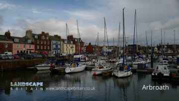
The area around Newtyle features a number of interesting towns including Arbroath, Kirriemuir, Forfar, Montrose, Monifieth, Carnoustie, and Brechin.
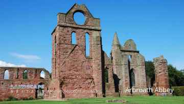
Places near Newtyle feature a number of interesting ruins including Arbroath Abbey.
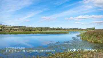
Don't miss Loch of Kinnordy's lakes if visiting the area around Newtyle.
The area around Newtyle's best nature reserves can be found at Loch of Kinnordy.
Woodlands to visit near Newtyle include Loch of Kinnordy.
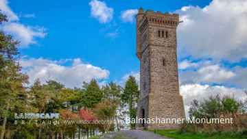
The area around Newtyle's best historic monuments can be found at Balmashanner Monument.
Newtyle History
There are some historic monuments around Newtyle:
- Braideston,enclosures 350m SE of Prehistoric domestic and defensive: enclosure (domestic or defensive) SM6352
- Kinalty,barrow 800m ESE of Prehistoric ritual and funerary: barrow SM6310
- Hurly Hawkin, enclosure, broch and souterrain 80m S of Prehistoric domestic and defensive: broch SM140
- Kettins Kirkyard,cross slab Crosses and carved stones: cross slab SM154
- Glenbran, ring fort 590m SE of Prehistoric domestic and defensive: ring fort SM7303
- Invergowrie, enclosure 150m SW of TA Centre Prehistoric domestic and defensive: enclosure (domestic or defensive) SM6517
- Eassie Old Church and cross slab Crosses and carved stones: cross slab; Ecclesiastical: church SM90125
- West Mains, cairn 700m NNE of Prehistoric ritual and funerary: cairn (type uncertain) SM6591
- Kinpurney Hill, fort Prehistoric domestic and defensive: fort (includes hill and promontory fort); Secular: tower SM3219
- Macbeth's Stone, standing stone Prehistoric ritual and funerary: standing stone SM2408
- Grangemount, unenclosed settlement 350m SSW of Prehistoric domestic and defensive: settlement SM7699
- Pitcrocknie,standing stone 400m W of Prehistoric ritual and funerary: standing stone SM1575
- Barry Hill, fort Prehistoric domestic and defensive: fort (includes hill and promontory fort) SM1591
- Barrows, 180m SW of Falcon Stone Prehistoric ritual and funerary: barrow SM6504
- Gourdie, stone circle 850m S of Prehistoric ritual and funerary: stone circle or ring SM128
- Castleward,burial mound 800m NW of Wester Denoon Prehistoric ritual and funerary: cairn (type uncertain) SM4742
- West Nevay,burial mound 1800m S of Prehistoric ritual and funerary: mound (ritual or funerary) SM4697
- Shanzie Farm,standing stone 400m N of Prehistoric ritual and funerary: standing stone SM1580
- Castlehill, barrows 210m SE of Prehistoric ritual and funerary: barrow SM7307
- Dron Chapel Ecclesiastical: cathedral SM5592
- Pictish symbol-bearing cross-slab, Kinnaird Mausoleum (formerly Rossie Church) Crosses and carved stones: symbol stone SM1658
- Jordanstone, unenclosed settlement SW of Prehistoric domestic and defensive: settlement SM7261
- Milton of Ruthven,ring ditch 250m NE of Prehistoric domestic and defensive: house SM6298
- Cardean, Roman fort 230m NW of Cardean Mill Roman: fort SM2306
- Carlinwell, standing stone 120m ENE of Mayfield Prehistoric ritual and funerary: standing stone SM4315
- Unenclosed settlement 260m ESE of Gray Cottage Prehistoric domestic and defensive: souterrain, earth-house SM6509
- Kinalty,cursus 500m E of Prehistoric ritual and funerary: cursus/bank barrow SM6309
- Unenclosed settlement, 315m E of Dovecot Cottage Prehistoric domestic and defensive: hut circle, roundhouse SM6508
- Newmill,ring ditch 600m SW of Prehistoric domestic and defensive: house SM6353
- Bridgend of Ruthven,souterrain SW of Prehistoric domestic and defensive: souterrain, earth-house SM6334
- Wallace Tower Secular: tower SM5436
- Selvie,ring ditch and pit enclosure 500m NE of Prehistoric domestic and defensive: house SM6350
- Meigle,rectangular enclosures & posthole setting 120m SE of Chapelton Prehistoric domestic and defensive: enclosure (domestic or defensive) SM3708
- Market Knowe,enclosure 340m SSE of North Bank Prehistoric domestic and defensive: enclosure (domestic or defensive) SM2879
- Hallyards Cottages, moated settlement S of Secular: homestead moat SM7262
- Kinpurnie Castle,cairn 400m WNW of Prehistoric ritual and funerary: cairn (type uncertain) SM6299
- Pitcur,souterrain NNE of Prehistoric domestic and defensive: souterrain, earth-house SM357
- Lendrick Lodge, standing stone 200m S of Prehistoric ritual and funerary: standing stone SM127
- Brockhill Park, enclosure 400m SSW of Balhary Prehistoric domestic and defensive: enclosure (domestic or defensive) SM7260
- Auchtertyre,barrow 300m NNW of Prehistoric ritual and funerary: barrow SM6300
- Belliduff, cairn 380m NE of Belmont Castle Prehistoric ritual and funerary: cairn (type uncertain) SM7325
- Balkeerie,unenclosed settlement 900m SSW of Newmill Prehistoric domestic and defensive: settlement SM6302
- Belmont Castle, standing stone 240m S of Prehistoric ritual and funerary: standing stone SM7296
- Cookston Farm, enclosure 100m W of Prehistoric domestic and defensive: enclosure (domestic or defensive) SM6281
- St Peter's Church & graveyard, Invergowrie Ecclesiastical: burial ground, cemetery, graveyard SM2996
- Nevay Church, church and burial ground, Kirkinch Ecclesiastical: burial ground, cemetery, graveyard SM3002
- Mylnefield, souterrains 290m and 385m E of Prehistoric domestic and defensive: souterrain, earth-house SM6468
- Dillavaird,palisaded homestead and souterrain 450m E of Prehistoric domestic and defensive: palisaded settlement SM6351
- East Adamston, souterrain and unenclosed settlement 670m NNE of Prehistoric domestic and defensive: settlement SM6465
- Unenclosed settlement 300m SW of Westwood SM6628
- Castleton, site of castle 90m SE of The Feathers Secular: motte SM3554
- Dundee and Newtyle Railway,embankment SW of Balbeuchly House Industrial: rail SM6123
- Paddock Stone,standing stone 90m NE of Greystone House Prehistoric ritual and funerary: standing stone SM2999
- Dronley Mill,enclosure 600m NE of Prehistoric domestic and defensive: enclosure (domestic or defensive) SM6466
- Huntly Farm, enclosures 300m ESE of Prehistoric domestic and defensive: enclosure (domestic or defensive) SM6559
- Lendrick Lodge, enclosure and barrows 300m ESE of Prehistoric domestic and defensive: enclosure (domestic or defensive); Prehistoric ritual and funerary: barrow SM6417
- Cursus and barrows, 240m NE of Bullionfield Prehistoric ritual and funerary: cursus/bank barrow SM6560
- Invergowrie, souterrains W of TA Centre Prehistoric domestic and defensive: souterrain, earth-house SM6516
- Wester Denoon,burial mound 950m W of Prehistoric ritual and funerary: cairn (type uncertain) SM4764
- Barns of Airlie, souterrain 495m WSW of Prehistoric domestic and defensive: souterrain, earth-house SM136
- Souterrains, 162m W of Westwood Prehistoric domestic and defensive: souterrain, earth-house SM6467
- Cardean Roman Camp and pre-historic barrow, Wester Cardean Prehistoric ritual and funerary: barrow; Roman: camp SM4337
- Barry Hill, ring fort Prehistoric domestic and defensive: ring fort SM6549
- Castlehill, unenclosed settlement 100m E of Prehistoric domestic and defensive: settlement SM7252
- Dronley House, mound 150m S of Prehistoric ritual and funerary: mound (ritual or funerary) SM6535
- Grangemount, unenclosed settlement 330m S of Prehistoric domestic and defensive: settlement SM7255
- Haughend, enclosure 500m W of Prehistoric domestic and defensive: enclosure (domestic or defensive) SM7263
- Reedie,souterrain 200m WNW of Prehistoric domestic and defensive: souterrain, earth-house SM6308
- Denoon Law, fort Prehistoric domestic and defensive: fort (includes hill and promontory fort) SM138
- Bruceton Farm, symbol stone 410m SSE of Crosses and carved stones: symbol stone SM1619
- St Moloc's Church,Alyth Ecclesiastical: church SM5583
- Hill of Dores, fort Prehistoric domestic and defensive: fort (includes hill and promontory fort) SM7315
- Falcon Stone, barrow 320m SSW of Prehistoric ritual and funerary: barrow SM6505
- Falcon Stone, cup-marked stone & barrow 500m SSE of Millhill Prehistoric ritual and funerary: barrow SM6503
- High Keillor, symbol stone and cairn, 280m NW of Crosses and carved stones: symbol stone; Prehistoric ritual and funerary: cairn (type uncertain) SM146
- Grange of Airlie,enclosure and cairn 700m SSW of Faulds Cottage Prehistoric domestic and defensive: enclosure (domestic or defensive); Prehistoric ritual and funerary: cairn (type uncertain) SM6307
- Kirkhowe of Ruthven,cairn 580m NNW of Prehistoric ritual and funerary: cairn (type uncertain) SM7079
- Dron Hill,fort Prehistoric domestic and defensive: fort (includes hill and promontory fort) SM3102
- Pitcur Castle Secular: castle SM7332