Glamis
Glamis is a Village in the county of Angus.
Glamis postcode: DD8 1RS
There are great places to visit near Glamis including some great towns, ruins, lakes, nature reserves, woodlands and historic monuments.
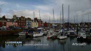
Don't miss Arbroath, Kirriemuir, Forfar, Montrose, Monifieth, Carnoustie, and Brechin's towns if visiting the area around Glamis.
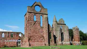
Places near Glamis feature a number of interesting ruins including Arbroath Abbey.
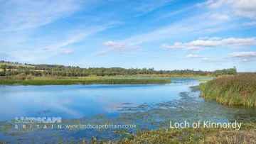
Don't miss Loch of Kinnordy's lakes if visiting the area around Glamis.
There are a number of nature reserves near to Glamis including Loch of Kinnordy.
Don't miss Loch of Kinnordy's woodlands if visiting the area around Glamis.
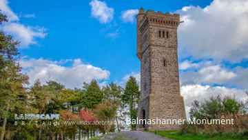
There are a number of historic monuments near to Glamis including Balmashanner Monument.
Glamis History
There are some historic monuments around Glamis:
- Arniefoul, cairn 820m NE of Prehistoric ritual and funerary: cairn (type uncertain) SM389
- Kirkton of Kingoldrum Farm, cairn and enclosure 320m NNE of Prehistoric ritual and funerary: cairn (type uncertain) SM6732
- Wester Denoon,burial mound 950m W of Prehistoric ritual and funerary: cairn (type uncertain) SM4764
- Castleward,burial mound 800m NW of Wester Denoon Prehistoric ritual and funerary: cairn (type uncertain) SM4742
- Nether Migvie,ring ditch E of Prehistoric domestic and defensive: house SM6470
- Balkello,standing stone Prehistoric ritual and funerary: standing stone SM6145
- Drumshade, enclosure 400m E of Prehistoric domestic and defensive: enclosure (domestic or defensive) SM6418
- Kinalty,cursus 500m E of Prehistoric ritual and funerary: cursus/bank barrow SM6309
- Dronley Mill,enclosure 600m NE of Prehistoric domestic and defensive: enclosure (domestic or defensive) SM6466
- Nether Arniefoul, unenclosed settlement 500m NE of Prehistoric domestic and defensive: settlement SM6423
- Souterrains, 162m W of Westwood Prehistoric domestic and defensive: souterrain, earth-house SM6467
- Mains of Brigton,enclosure 500m N of Prehistoric domestic and defensive: enclosure (domestic or defensive) SM6047
- Newton of Glamis, unenclosed settlement 100m W of Prehistoric domestic and defensive: settlement SM6421
- Caddam,souterrain 350m ENE of Prehistoric domestic and defensive: souterrain, earth-house SM6345
- Kinalty,barrow 800m ESE of Prehistoric ritual and funerary: barrow SM6310
- Meams, cairns 540m W of & 480m WNW of Balnagarrow Prehistoric ritual and funerary: cairn (type uncertain) SM4472
- Shielhill,pit alignments 200m NE of Shielhill Farm Prehistoric domestic and defensive: pit alignment; Prehistoric ritual and funerary: pit alignment (ritual or funerary) SM6349
- Tealing, souterrain Prehistoric domestic and defensive: souterrain, earth-house SM90299
- Cookston Farm, enclosure 100m W of Prehistoric domestic and defensive: enclosure (domestic or defensive) SM6281
- Northmuir,enclosure 350m N of Hill of Kirriemuir Prehistoric domestic and defensive: enclosure (domestic or defensive) SM6346
- Loch of Kinnordy, crannog 500m NW of Balbrydie Prehistoric domestic and defensive: crannog SM5640
- Carlunie Hill, cairn Prehistoric ritual and funerary: cairn (type uncertain) SM6449
- Tealing,dovecot Secular: doocote, dovecote, pigeon loft SM90298
- Redwell,enclosure 700m NE of Prehistoric domestic and defensive: enclosure (domestic or defensive) SM6354
- Fletcherfield,enclosure 100m SE of Prehistoric domestic and defensive: enclosure (domestic or defensive) SM5911
- Glamis Castle, enclosure 600m ENE of Prehistoric domestic and defensive: enclosure (domestic or defensive) SM6420
- Dundee and Newtyle Railway,embankment SW of Balbeuchly House Industrial: rail SM6123
- Hill of Kirriemuir, standing stone Prehistoric ritual and funerary: standing stone SM125
- St Orland's Stone, Glamis Crosses and carved stones: cross slab SM90270
- Lendrick Lodge, standing stone 200m S of Prehistoric ritual and funerary: standing stone SM127
- Newmill,ring ditch 600m SW of Prehistoric domestic and defensive: house SM6353
- Denoon Law, fort Prehistoric domestic and defensive: fort (includes hill and promontory fort) SM138
- Glamis 1, cross slab 140m WSW of Loanhead Crosses and carved stones: cross slab SM151
- Over Ascreavie, cairn 600m NNE of Prehistoric ritual and funerary: cairn (type uncertain) SM6810
- Culhawk Hill,house 500m N of Culhawk Prehistoric domestic and defensive: house SM4492
- Carlunie Hill, hut platforms 300m E of summit Prehistoric domestic and defensive: platform SM6450
- Caldhame Wood,Roman road Roman: road SM143
- Huntingfaulds, cairn 200m N of Prehistoric ritual and funerary: cairn (type uncertain) SM6562
- Martin's Stone, cross slab, Balkello Crosses and carved stones: cross slab SM159
- Wester Logie,enclosures 250m SSW of Prehistoric domestic and defensive: enclosure (domestic or defensive) SM6313
- Kirkton,homestead moat 350m W of Secular: homestead moat SM6070
- Craig Hill,fort and broch Prehistoric domestic and defensive: fort (includes hill and promontory fort) SM3038
- Caddam, standing stone 700m ESE of Prehistoric ritual and funerary: standing stone SM150
- Reedie,souterrain 200m WNW of Prehistoric domestic and defensive: souterrain, earth-house SM6308
- Glamis 2, cross slab 15m S of 10 Kirkwynd Crosses and carved stones: cross slab SM152
- Balstard, cairn 660m NE of Prehistoric ritual and funerary: cairn (type uncertain) SM8505
- Shielhill,pit alignments N of Shielhill Farm Prehistoric domestic and defensive: pit alignment; Prehistoric ritual and funerary: pit alignment (ritual or funerary) SM6348
- Westfield,enclosure SW of Prehistoric ritual and funerary: enclosure (ritual or funerary) SM6054
- Ballinshoe Castle, 370m ENE of Ballinshoe Secular: castle SM162
- Balkeerie,unenclosed settlement 900m SSW of Newmill Prehistoric domestic and defensive: settlement SM6302
- Newton of Glamis, enclosure 400m SSE of Prehistoric domestic and defensive: enclosure (domestic or defensive) SM6422
- Longbank,enclosure 400m NNW of Prehistoric domestic and defensive: enclosure (domestic or defensive) SM6347
- Reedie,cairns 850m NNW and 850m NW of Prehistoric ritual and funerary: cairn (type uncertain) SM4582
- Wallace Tower Secular: tower SM5436
- Castleton, site of castle 90m SE of The Feathers Secular: motte SM3554
- Culhawk Hill, stone circle 390m WNW of Balstard Prehistoric ritual and funerary: stone circle or ring SM4475
- Unenclosed settlement 300m SW of Westwood SM6628
- Dronley House, mound 150m S of Prehistoric ritual and funerary: mound (ritual or funerary) SM6535
- Lendrick Lodge, enclosure and barrows 300m ESE of Prehistoric domestic and defensive: enclosure (domestic or defensive); Prehistoric ritual and funerary: barrow SM6417
- Westfield,enclosures NW of Prehistoric ritual and funerary: enclosure (ritual or funerary) SM6053
- Queen Margaret's Inch, chapel and crannog Ecclesiastical: chapel; Prehistoric domestic and defensive: crannog SM7648
- East Balloch,burial mound 500m W of Prehistoric ritual and funerary: barrow SM4583
- Castle Hill,fort and house 700m WNW of Meams Prehistoric domestic and defensive: fort (includes hill and promontory fort) SM4420
- West Nevay,burial mound 1800m S of Prehistoric ritual and funerary: mound (ritual or funerary) SM4697
- Eassie Old Church and cross slab Crosses and carved stones: cross slab; Ecclesiastical: church SM90125
- Balkemback Cottages, stone circle 500m WNW of Prehistoric ritual and funerary: stone circle or ring SM2868
- Fletcherfield,two standing stones Prehistoric ritual and funerary: standing stone SM119
- East Adamston, souterrain and unenclosed settlement 670m NNE of Prehistoric domestic and defensive: settlement SM6465