The Nine Stones by Steve Simmons from Getty Images
The Nine Stones
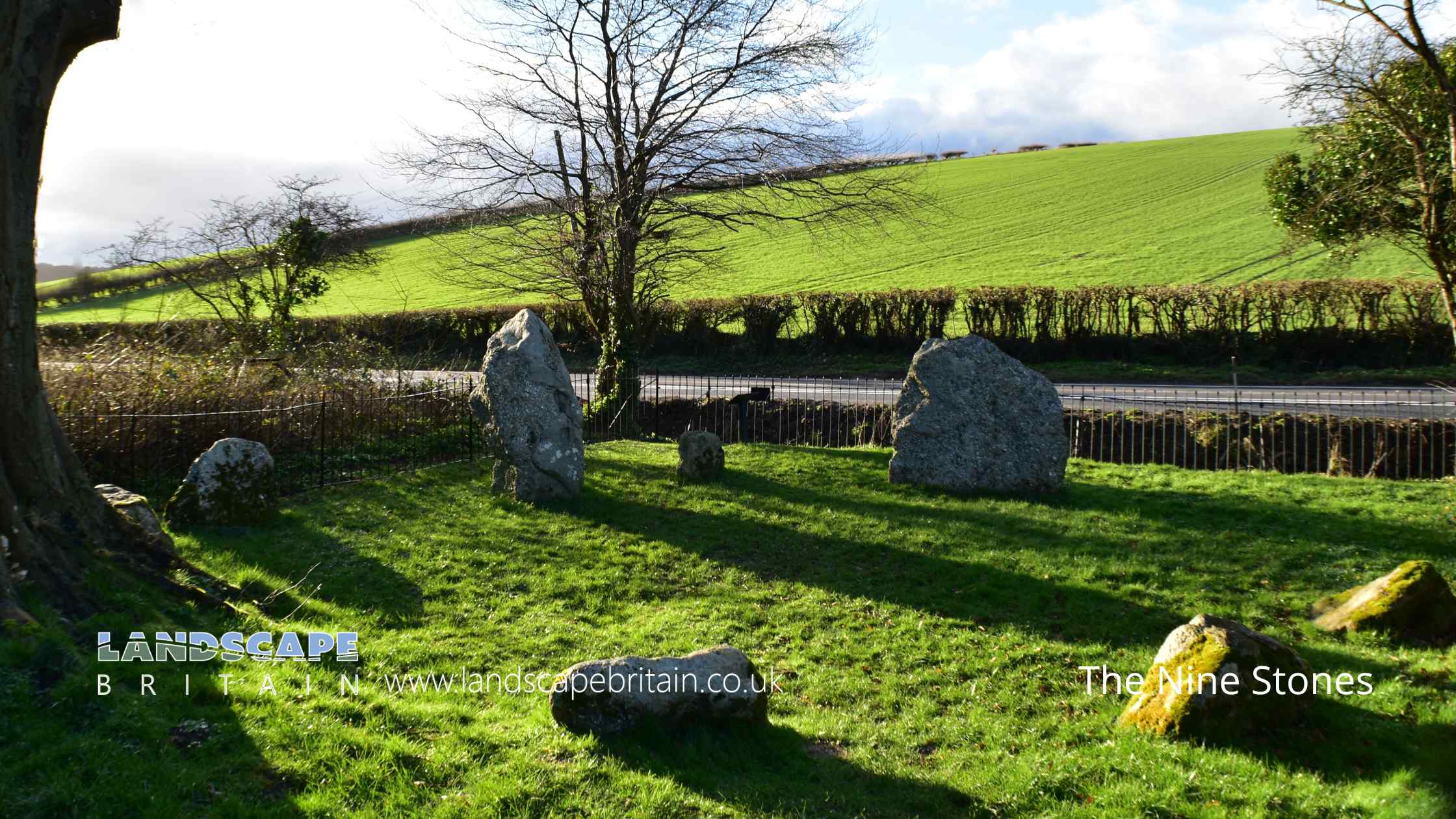
The Nine Stones is a small but significant stone circle located near Winterbourne Abbas in Dorchester, situated in the tranquil valley bottom of the South Dorset Downs but next to a busy road, close to the South Winterbourne stream. This prehistoric monument, known for its historical and archaeological value, was first documented in the 18th century by notable antiquarians such as John Aubrey, William Stukeley, and William Hutchins. Their early descriptions remarkably match the current appearance of the site, underscoring its enduring presence through the centuries.
The circle comprises stones made of sarsen or conglomerate, arranged in an irregular yet discernible circular formation. The internal diameter of the circle measures approximately 8 meters, with the stones varying in size. They range from 1.5 meters to 0.5 meters in width and 1.5 meters to 0.45 meters in height. These stones, partially buried over time, might be larger than what is visible on the surface. Notably, the two largest stones, located in the northern and western sections of the circle, each measure around 1.5 meters by 1.5 meters, suggesting their prominence or possible significance within the arrangement.
The stones are generally spaced at regular intervals of about 1 meter around the circle, except for a 3-meter gap on the northern side, which could indicate a potential entrance to the circle. This feature adds an element of intrigue, possibly hinting at the circle’s original use or symbolic meaning. While modern additions such as fence posts, gates, and an informational notice board are present, these are excluded from the site’s official scheduling to preserve its historical integrity. The ground beneath, however, remains protected, ensuring that the Nine Stones continues to be a valuable link to our prehistoric past.
Created: 26 May 2024 Edited: 10 June 2024
The Nine Stones
The Nine Stones LiDAR Map

Contains public sector information licensed under the Open Government Licence v3.0
Local History around The Nine Stones
There are some historic monuments around including:
St Catherine's Chapel, field system and quarries at Chapel HillBowl barrow on Black Down, 400m north west of the Hardy MonumentBowl barrow 810m NNE of Whatcombe House, forming part of the round barrow cemetery on the south western part of Black DownBell barrow and five bowl barrows 1000m south east of Kingston Russell Farm, part of the Black Down round barrow cemeteryEnclosure on Sheep Down 930m south east of Heart ClumpBell barrow 100m south of Winterbourne Poor Lot, part of the Winterbourne Poor Lot round barrow cemeteryDyke on Wears HillRound barrow NW of Long Bottom PlantationDyke on Long Barrow HillBowl barrow 500m west of Well Bottom Wood, forming part of the Pitcombe Down round barrow cemeteryCross-ridge dyke on WindsbatchBowl barrow 605m south west of Long Barrow FarmBowl barrow on Black Down, 80m south east of the Hardy MonumentLong barrow NW of Red BarnRound barrow on Stratton DownLynchets S of Stavordale WoodRound barrows on Four Barrow HillBowl barrow 140m south east of Broadwater CottageRound barrow SW of Ashton CottagesHelstone burial chamberTwo round barrows on Wears HillTwo bowl barrows on Black Down immediately east of the Hardy MonumentDuck decoy at Abbotsbury Swannery, 630m SSW of Horsepool FarmStanding stone 700m south east of North Barn FarmThree round barrows E of Smitten CornerBowl barrow 450m NNE of West Hill FarmGroup of round barrows on Shorn Hill and Bronkham HillBowl barrow 680m north east of Whatcombe House, forming part of the round barrow cemetery on the south western part of Black DownBowl barrow 300m WNW of White Hill Barn, forming part of the White Hill round barrow cemeteryRound barrow on Shorn HillRound barrow NE of Hog Hill BarnBarrow S of Three-Cornered PlantationThe Clandon Barrow, 450m west of Clandon FarmThree barrows S of Hart Hill PlantationSt Peter's AbbeyLong mound and three bowl barrows forming part of a round barrow cemetery 760m NNE of Whatcombe House on the south western part of Black DownTwo barrows at RewBowl barrow 550m north east of Pitcombe Farm, part of the Black Down round barrow cemeteryBarrow on parish boundaryBowl barrow 500m NNW of Topparts DairyBowl barrow 360m south of Compton BarnPigeon House long barrowRound barrows on Sheep DownRound barrows W of Blagdon BarnRound barrow on Rew HillThree barrows N of Penn HillField system W of Fore HillBowl barrow on Black Down, 450m north west of the Hardy MonumentBowl barrow 770m north of Whatcombe House, forming part of the round barrow cemetery on the south western part of Black DownStanding stone called The Broad StoneBowl barrow 400m north east of Manor Farm, part of the Pound Hill round barrow cemeteryBowl barrow 800m NNE of Whatcombe House, forming part of the round barrow cemetery on the south western part of Black DownThe Kingston Russell stone circle 750m north east of Gorwell FarmBowl barrow 660m south west of ChilstockBowl barrow 750m SSE of Lower Kingston Russell FarmGroup of barrows S of Goldsmith's PlantationRound barrow NW of Jackman's CrossMedieval standing cross 11m south east of the south porch of St Mary's ChurchTriple barrow and bowl barrow forming part of a barrow cemetery and part of an associated field system 250m north east of Winterbourne Poor LotGroup of three round barrows SW of Longlands BarnGroup of round barrows on RidgewayRound barrow in White Hill PlantationBowl barrow 780m north east of Hampton FarmFrampton Roman villaPart of a Later Iron Age or Romano-British settlement 590m north west of Compton BarnFour bowl barrows 725m ESE of Wears FarmBowl barrow and disc barrow 730m south of Kingston Russell Farm, forming part of the round barrow cemetery on the south western part of Black DownGroup of round barrows on and to E of Great HillThree bowl barrows at Dry Wood, forming part of the Longlands round barrow cemeteryRound barrow SW of villageFriar Waddon Hill round barrowsBowl barrow 300m west of New Planting, forming part of the Three Barrow Clump round barrow cemeteryTwo bowl barrows 720m south east of Friar Waddon HouseBowl barrow180m east of Hogleaze BungalowRound barrow SW of Pigeon House CottagesBowl barrow on Black Down, 150m north west of the Hardy MonumentBowl barrow 450m north east of Manor Farm, part of the Pound Hill round barrow cemeteryTwo fishponds in Oddens WoodLong barrow 200m north west of Longlands FarmTwo bell barrows 15m north of Well Bottom Wood, part of the Poor Lot round barrow cemeteryBowl barrow on Sheep Down, 600m east of Home Farm CottagesSix round barrows 200m west of New Planting, forming part of the Three Barrow Clump round barrow cemeteryTwo bowl barrows 700m south east of Kingston Russell Farm, part of the Black Down round barrow cemeteryBowl barrow in New Planting, forming part of the Three Barrow Clump round barrow cemeteryGroup of round barrows near Eweleaze BarnLong barrow NE of AshleyChambered tomb called The Grey Mare and her ColtsBowl barrow 165m NNW of White Hill Barn, forming part of the White Hill round barrow cemeteryBowl barrow1050m WNW of Manor FarmBowl barrow 800m south of Kingston Russell Farm, forming part of the round barrow cemetery on the south western part of Black DownHampton stone circleThe Nine Stones: a small concentric stone circle 750m west of Winterbourne AbbasBowl barrow 800m north east of Gorwell FarmGroup of barrows in Seven Barrow PlantationRound barrow N of RidgewayLong mound 860m NNE of Whatcombe House, associated with the round barrow cemetery on the south western part of Black DownRound barrow 1/4 mile (400m) N of Ridge HillTwo round barrows at crossroads N of villageRound barrow E of Two GatesBowl barrow 700m NNW of Whitefriars Broiler HousesLong barrow W of Hampton BarnTwo long barrows and round barrows on Long Barrow HillBowl barrow 220m NNW of Topparts DairyRound barrow on Pound HillTwo bowl barrows 283m SSE of the Grey Mare and her ColtsBowl barrow and pond barrow within Well Bottom Wood, part of the Winterbourne Poor Lot round barrow cemeteryBell barrow 125m west of Longlands Farm, forming part of the Longlands round barrow cemeteryRound barrow on Hogcliff HillBarrow 300yds (280m) SW of Kingston FarmBowl barrow 120m east of White Hill WoodBowl barrow 645m south west of North Barn FarmEarthwork N of Hampton PlantationsRound barrow NE of Friar WaddonTwo round barrows on North HillBell barrow 850m south east of Kingston Russell Farm, part of the Black Down round barrow cemeteryTwo round barrows on RidgewayBowl barrow 600m west of Well Bottom Wood, forming part of the Pitcombe Down round barrow cemeteryTwo bowl barrows 1250m east of Notton Hill BarnCross in St Mary's churchyardFour round barrows NW of Blagdon BarnBowl barrow 350m NNW of Topparts DairyField system in Valley of Stones (including earthwork N of Crow Hill)Bowl barrow 850m north west of Whitefriars Broiler HousesTwo conjoined bowl barrows 550m north east of Manor FarmOld Warren earthworkWynford Wood boundary bankThree barrows near Town Hill BarnMedieval standing cross 190m south east of St Mary's ChurchBowl barrow on Black Down, 770m north west of the Hardy MonumentBowl barrow 550m WNW of Dowerfield HouseRound barrow 250yds (230m) S of Chapel CoppiceBowl barrow 360m south west of Clandon FarmBowl barrow 600m west of Well Bottom Wood, forming part of the Pitcombe Down round barrow cemeteryBowl barrow 355m north west of White Hill Barn, forming part of the White Hill round barrow cemeteryBowl barrow and pond barrow 880m south east of Kingston Russell Farm, part of the Black Down barrow cemeteryGroup of three round barrows NE of Jackman's CrossDisc barrow 500m south east of Winterbourne Poor LotGroup of five round barrows on White HillCross dyke 600m north of Pitcombe FarmRound barrows on Grove HillRound barrow E of The BuildingsRound barrow N of Ballarat HouseBarrow E of Red BarnThree bowl barrows 300m south west of Well Bottom Wood, forming part of the Pitcombe Down round barrow cemeteryBowl barrow 265m north west of White Hill Barn, forming part of the White Hill round barrow cemeteryBowl barrow on Black Down, 50m south of the Hardy MonumentMulti-period landscape including an Iron Age or Romano British settlement, part of an associated field system, six bowl barrows and an enclosure 600m south east of Langford FarmBowl barrow 450m NNW of Field BarnBowl barrow 340m north west of White Hill Barn, forming part of the White Hill round barrow cemeteryGroup of barrows near Big WoodRound barrows N of Pound HillBowl barrow and disc barrow 900m south east of Kingston Russell Farm, part of the Black Down round barrow cemeteryBowl barrow on Black Down, 870m north west of the Hardy MonumentBowl barrow in Well Bottom WoodBowl barrow 200m south of Winterbourne Poor Lot forming part of the Winterbourne Poor Lot round barrow cemeteryTwo bowl barrows 400m west of Longlands Farm, forming part of the Longlands round barrow cemeteryTwenty-one barrows forming part of a round barrow cemetery at Winterbourne Poor LotBronze Age enclosure, associated linear earthworks and field system, and a later dewpond on Tenants HillBowl barrow185m WSW of Higher Skippet FarmDisc barrow 200m north east of Winterbourne Poor Lot, forming part of the Poor Lot round barrow cemeteryLong barrow E of Northfield PlantationRound barrow 230yds (210m) E of White Hill PlantationRound barrow on Magiston HillBarrow 650yds (600m) N of North Barn FarmRound barrow in Grimstone ClumpsFour bowl barrows 500m west of Well Bottom Wood, forming part of the Pitcombe Down round barrow cemeteryChambered long barrow N of Loscombe Plantation.


