
Hartshead Pike Tower
Hartshead Pike Tower
Hartshead Pike: The Tower, the Well, and the Stories in Stone
Hartshead Pike, rising 287.4 metres (943 feet) above sea level on the ridge northeast of Ashton-under-Lyne, is a familiar landmark visible from much of east Greater Manchester. But for all its visual prominence, the Pike keeps its secrets. How many know the tower standing there today is the third—possibly fourth—structure to mark the summit? Or that the “well” beside it is almost certainly not a well at all?
Recent scrutiny of historical maps, architectural materials, and local heraldry has begun to clarify long-standing uncertainties. This account pulls together what we now know—or suspect—about the various layers of history built into Hartshead Pike.
Phase I: Beacon and Watchpoint (Pre-15th Century?)
Local tradition and some sources claim that a beacon or early signal tower existed on Hartshead Pike as far back as 1426. While no architectural evidence from that period survives, the location is consistent with other beacon hills used for warning systems during medieval and Tudor times. The wide views across at least four counties make it a natural candidate.
Phase II: The 18th-Century Tower (1751–1820)
A dated plaque built into the current tower reads:
“This Pike was rebuilt by Publick Contributions Anno Dom 1751”
This inscription, carved in soft sandstone and clearly older than the gritstone of the surrounding wall, likely belonged to a previous structure. That tower, according to accounts, was damaged by lightning in 1794 and collapsed by 1820 after a long structural crack developed.
Interestingly, the 1844 Ordnance Survey map shows no tower labelled, but a large rounded feature is present at the summit, possibly the remains or base of the 18th-century structure. Two smaller rectangular marks are also shown nearby—one where the present “well” lies and another to the north, now the site of a small pile of rubble. The area is labelled “Sandstone Quarries,” indicating that earlier structures may have been dismantled for stone.
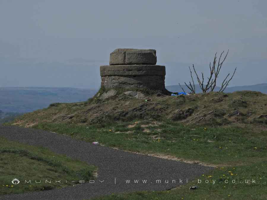
Phase III: The 1863 Tower – Civic Pride and Aristocratic Symbols
The current tower was built in 1863 to commemorate the marriage of the Prince of Wales (later Edward VII) to Princess Alexandra. A tripartite inscription on the tower records this purpose and credits the rebuild to public subscription.
Notably, the same plaque also names George Harry Booth-Grey, 7th Earl of Stamford and 3rd Earl of Warrington, as Lord of the Manor, with the foundation stone laid by Samuel Duckworth Lees, M.D., Mayor of the Manor.
The tower also features a carved coat of arms with two unicorns and the motto “A Ma Puissance” (“According to my power”). This is not a royal crest, but the personal arms of the Grey family, Earls of Stamford—major local landowners at the time. The same arms appear on Ashton Market Hall, directly linking the tower to civic and aristocratic pride.
The So-Called Well
Beside the tower is a circular stone feature with a large flat rock covering the opening — commonly referred to as a “well.” But that name is almost certainly wrong.
At this elevation, with no natural spring activity and the Pike sitting on a sandstone ridge, a water well would have to be ridiculously deep. A more likely explanation is that it’s a sealed air shaft connected to Broad Carr Colliery, which operated just to the north of the Pike. It lines up with one of the rectangular structures shown on the 1844 Ordnance Survey map. The heavy stone slab looks like a deliberate cap — probably for safety — not the top of a drinking water source.
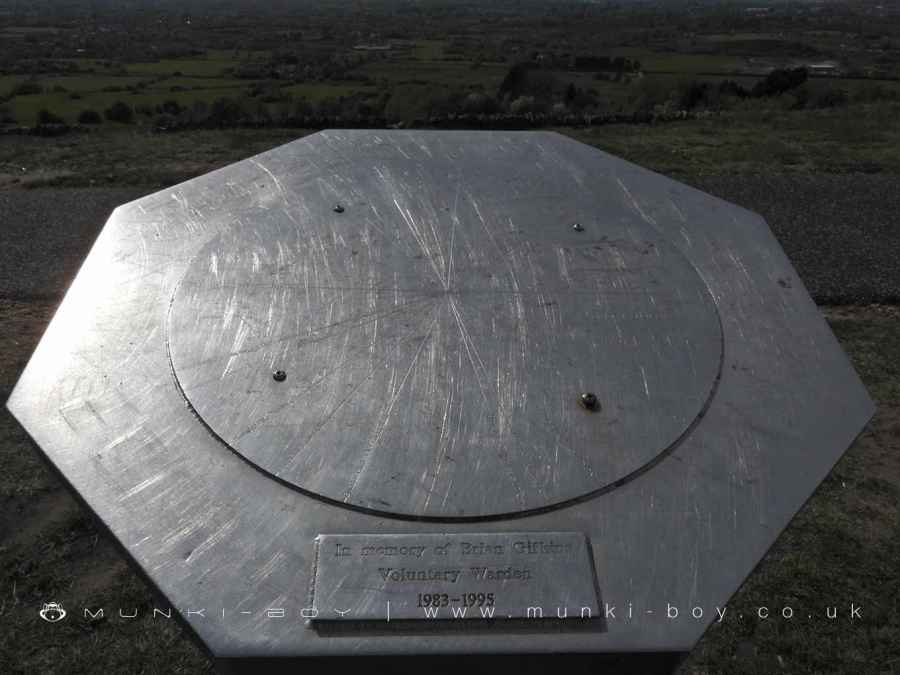
The Viewpoint and What You Can See
Just beside the tower is a modern viewpoint plaque listing visible landmarks and their distances. On clear days, visitors can see:
- Nearby: Brown Edge (0.5 km), Wild Bank (3.75 km), and Buckton Castle (3 km)
- Mid-range: Manchester City Centre (13 km), Bolton (25.5 km), and Winter Hill (33 km)
- Distant: Jodrell Bank (37.5 km), Fiddlers Ferry (49.5 km), and even the Welsh Hills (110 km)
The Pike’s elevation and open position make it a superb viewing platform—one of the reasons it has remained a focal point for centuries.
A Landmark in Layers
What appears today as a single Victorian folly is, in fact, a multi-era construction. From its supposed role as a beacon, through 18th-century community effort and 19th-century aristocratic symbolism, Hartshead Pike has accumulated meanings as well as masonry.
The supposed “well” is likely a relic of industrial quarrying; the older plaques are genuine fragments of a vanished tower; and the crest of the Earls of Stamford confirms a very specific historical context for the 1863 rebuild.
It is not just a pretty viewpoint. Hartshead Pike is a coded monument, telling the story of a community, a class system, a landscape, and an enduring sense of place—if you know where to look.
Created: 4 November 2022 Edited: 5 May 2025
The Hartshead Tower(s)


Hartshead Pike Tower Information
Hartshead Pike Tower Address
Back Lane, Ashton-under-Lyne
OL6 9AF
Local History around Hartshead Pike Tower
There are some historic monuments around including:
Bowl barrow 190m NNE of Knarr BarnCastleshaw Roman forts, 250m west of Castle Shaw FarmRound cairn west of Hollingworthhall MoorBuckton Castle: a ringwork and site of 17th century beacon 350m north east of Castle Farm.


