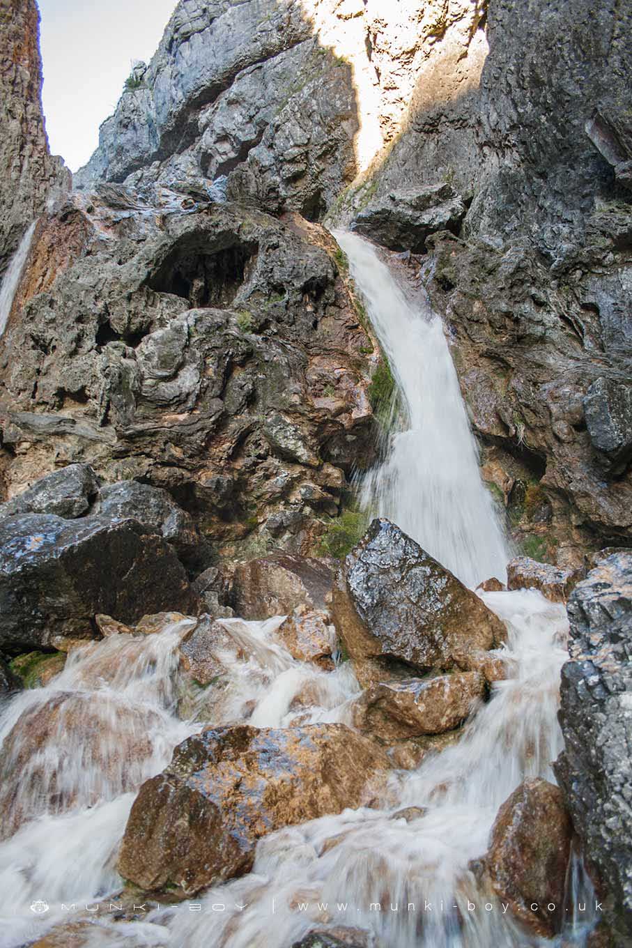
Gordale Scar Lower Waterfall by munki-boy
Gordale Scar Lower Waterfall
Gordale Scar Lower Waterfall is in The Yorkshire Dales National Park in England.
The lower waterfall at Gordale Scar is the barrier for people who turn back down the path from the scar, and those who climb and continue on. The rocks are slippy and treacherous in bad weather but it is not too bad a climb for the able bodied. Once past the waterfall there is a rocky path - sometimes a bit of a scramble.
Created: 24 July 2019 Edited: 29 November 2023
Malham Tarn Estate Information
Malham Tarn Estate Address
Yorkshire Dales Estate Office, Pennine Way, Settle BD24 9PT, UK
BD24 9PT
Website: https://www.nationaltrust.org.uk/malham-tarn-estate
Get directionsGordale Beck from Source to Malham Beck Details
Gordale Beck from Source to Malham Beck
Gordale Beck from Source to Malham Beck is a river in West Yorkshire
Gordale Beck from Source to Malham Beck takes in water from an area around 12.61 km2 in size and is part of the Aire Upper catchment area.
Gordale Beck from Source to Malham Beck is 7.225 km long and is not designated artificial or heavily modified.
Gordale Scar Lower Waterfall LiDAR Map

Contains public sector information licensed under the Open Government Licence v3.0
Local History around Gordale Scar Lower Waterfall
There are some historic monuments around including:
Hut circle on Comb ScarSettlement on Cow Bank 1/4 mile (400m) NW of DarnbrookRound barrow 400m south west of Crane Field LaitheSettlement SE of Druid's AltarLynchets N of Malham villageSettlement on Blue ScarSettlement at Dew BottomsLower Colgarth Hill round cairnCrane Field round barrowDruid's Altar four poster stone circleSeaty Hill round cairnMedieval monastic wayside cross base, Water Sinks GateEnclosed prehistoric settlement east of Malham CoveMedieval monastic wayside cross baseEnclosure E of Malham LingsField system S of Malham CoveCairn on Blue Scar 460m NW of Springs CaveCup marked rock in wall east of Scarnber Wood, 500m north east of Bark Laithe, Winterburn'Douky Bottom Cave' Hawkswick Clowder, near KilnseyRoman temporary camp and medieval monastic cross base, Mastiles Lane.Pillow mounds east of Friars Head, known as Giants' GravesMedieval monastic wayside cross baseRound cairn south east of Broad FlatsCairn on Great Close HillSettlement on Prior RakesMedieval settlements and lynchets extending NW from Town HeadFarm sites and field systems on Malham LingsCairn 80m north of Pikedaw HillSettlement on Ing ScarSheriff Hill round cairnSettlement N of Stridebut EdgeRound barrow 550m south west of Park HillKilnsey Moor settlementEnclosure and hut circles on Prior RakesTwo rectangular house sites on Malham LingsHut circles, enclosures and fields N of Shorkley HillSettlement 1250yds (1140m) NE of Malham Tarn HouseSettlement sites on Jorden ScarRound cairn on Broad FlatsRound barrow north of Moor Syke, Crane FieldRing cairn north west of Ewe MoorFarmhouse sites on Highfolds ScarSettlement 500ft (150m) NW of Ing Scar CragSettlement 1/3 mile (540m) NW of Langscar GateLime kiln and associated quarry 75m south of High Scarth BarnPikedaw Hill southern cairn.