Cheddar Gorge by RJL
Cheddar Gorge
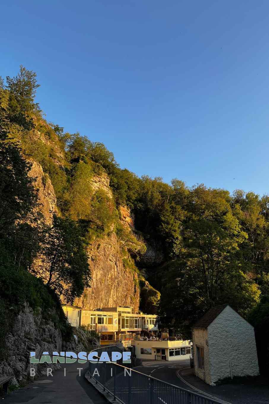
Cheddar Gorge and Caves stand as one of the UK’s most iconic natural wonders, drawing visitors from all corners of the world. Situated in Somerset’s scenic landscape, the gorge presents a breathtaking spectacle with its sheer limestone cliffs that rise dramatically from the ground, stretching over three miles in length and reaching heights of up to 450 feet. The result of millions of years of water and ice erosion, the gorge tells a captivating tale of Earth’s geologic history.
But the wonders of Cheddar aren’t confined to its exterior. Deep within the cliffs lie the mystifying Cheddar Caves, a labyrinth of underground caverns and tunnels. Here, stalactites hang like chandeliers, and stalagmites rise from the cave floor, with some formations believed to be over 500,000 years old. The caves have not only inspired awe for their natural beauty but also have immense archaeological significance. They have unveiled clues about our prehistoric ancestors, including the discovery of the “Cheddar Man,” the oldest complete human skeleton found in the UK, believed to be over 9,000 years old.
Beyond their geologic and archaeological allure, the Cheddar Gorge and Caves have been interwoven with local legends and folklore. They have served as a backdrop for countless tales and stories, further embedding them in the cultural tapestry of the region. For both the casual visitor and the ardent geologist or historian, Cheddar Gorge and Caves promise a journey of discovery, wonder, and connection to the ancient world.
Cheddar Gorge is in Mendip Hills AONB, a designated Area of Outstanding Natural Beauty.
Created: 11 August 2023 Edited: 29 November 2023
Cheddar Caves and Gorge Cheddar Information
Cheddar Caves and Gorge Cheddar Address
Cheddar BS27 3QF, UK
BS27 3QF
Website: http://www.cheddargorge.co.uk/
Get directionsCheddar Gorge LiDAR Map

Contains public sector information licensed under the Open Government Licence v3.0
Local History around Cheddar Gorge
There are some historic monuments around including:
Duck decoy 175m south west of Parson's FarmGroup of three bowl barrows 180m south of Tyning's Farm: part of the Tyning's Farm round barrow cemeteryBowl barrow 70m northeast of King Down FarmBowl barrow 770m south of Townsend FarmBowl barrow 760m southeast of Bristol Plain FarmLinear barrow cemetery comprising six bowl barrows 510m south west of Townsend FarmAveline's Hole, Burrington CombeBowl barrow 820m south of Bristol Plain Farm: part of a linear round barrow cemeteryRoman amphitheatre 1/2 mile (800m) N of CharterhouseBowl barrow 400m north of Stoke WoodsBowl barrow 550m south east of Brimble Pit Pool: one of a group of round barrows north and east of Foxhills WoodBowl barrow 330m east of Batts Coombe QuarryLong barrow 600m east north east of Brimble Pit PoolBowl barrow 350m northeast of Cheddar Head FarmBowl barrow 75m south west of Long House BarnDuck decoy east of Barrow Wood LaneWestbury Camp, slight univallate hillfort, 750m north of Stokewood CottageBowl barrow 430m southwest of King Down FarmRowberrow Camp: an Iron Age defended settlement north west of Tynings FarmStar Roman villa, 275m north east of WimblestoneBowl barrow 700m south of Bristol Plain Farm: part of a linear round barrow cemeteryBowl barrow 300m north east of Tyning's FarmDolebury Camp: a large univallate hillfort and associated and later earthworks on Dolebury WarrenBowl barrow 250m south east of Tyning's Farm: part of the Tyning's Farm round barrow cemeteryPair of bowl barrows 640m south of Bristol Plain Farm: part of a linear round barrow cemeteryGough's Old CaveBowl barrow 450m east of Bristol Plain FarmBowl barrow 730m southeast of Bristol Plain FarmBowl barrow 550m southwest of NordrachRoman settlement site, Anglo-Saxon and Norman royal palace, and St Columbanus' ChapelBowl barrow 250m south west of Ashridge FarmLongbottom Farm earthworkBowl barrow 190m south west of Tyning's Farm: part of the Tyning's Farm round barrow cemeteryBowl barrow 590m south-east of Charterhouse Warren FarmBowl barrow 460m east of Charterhouse Warren FarmBowl barrow 430m north east of Stoke WoodsSun Hole, Cheddar GorgeMedieval estate boundary earthwork on Shute Shelve HillDeserted medieval hamlet E of DraycottBowl barrow 900m south west of Bristol Plain Farm: part of a group of round barrows south and south west of Bristol Plain FarmBowl barrow 400m southeast of Wellington FarmBowl barrow 91m south of Piney Sleight FarmBowl barrow, 455m west of Brimble Pit PoolBowl barrow 800m south of Townsend FarmRomano-British settlement on Stoke MoorBowl barrow 870m southwest of Dale FarmBowl barrow 300m east of Batts Coombe QuarryRowberrow Cavern, Mendip ForestBowl barrow 180m southwest of Yoxter FarmBowl barrow 870m southwest of Charterhouse Warren FarmBowl barrow 420m east of Bristol Plain FarmBowl barrow 180m west of Ubley Warren FarmWestbury village crossBowl barrow 550m south of Bristol Plain Farm: part of a linear round barrow cemeteryCalamine mining remains, south of Glovers FieldCharterhouse lead worksDuck decoy, west of Nyland HillGough's Cave, Cheddar GorgeTwo bowl barrows 350m south of Brimble Pit Pool: part of a group of round barrows north and east of Foxhills WoodBowl barrow 810m southeast of Bristol Plain FarmGorsey Bigbury earth circle and round barrow near LongwoodDeserted medieval farmstead and field system NW of Ebbor WoodSoldier's Hole, Cheddar GorgeWorld War II anti-aircraft rocket battery and bombing decoy control building 265m north east of Ashridge FarmWimblestone standing stoneBowl barrow 150m southwest of King Down FarmBowl barrow 340m north-east of Wellington FarmGreat Oone's HoleVillage crossMarket cross at the junction of Bath Street, Union Street and Church StreetSlight univallate hillfort and associated earthworks on Burrington HamBowl barrow 430m northwest of King Down FarmBowl barrow 250m northeast of King Down FarmBowl barrow 330m north of Stoke WoodsBowl barrow, 540m west of Brimble Pit PoolWayside cross at Stoughton CrossCamp 600yds (548m) E of CharterhouseRoman settlement at Town FieldBowl barrow 400m west of Bellevue HouseBowl barrow 220m south west of Ubley Hill FarmhouseBowl barrow 420m north of Stoke WoodsTwin round barrows 750yds (696m) N of Bowpit FarmBowl barrow 365m south west of Ubley Warren FarmSaye's Hole, Cheddar GorgeWestbury Beacon, a bell barrow 720m west of Brimble Pit PoolBowl barrow 850m southeast of Bristol Plain FarmRound barrows 600yds (550m) NW of Longbottom FarmWorld War II bombing decoy complex, anti-aircraft obstructions and Beacon Batch round barrow cemetery on Black DownBowl barrow 850m south of Bristol Plain Farm: part of a linear round barrow cemeteryBowl barrow 410m northeast of Bristol Plain FarmBowl barrow 390m northeast of Bristol Plain FarmBowl barrow 350m east of Batts Coombe QuarryTwo bowl barrows 850m south east of Brimble Pit Pool: part of a group of round barrows north and east of Foxhills Wood.


