Badbury Rings by Wirestock from Getty Images
Badbury Rings
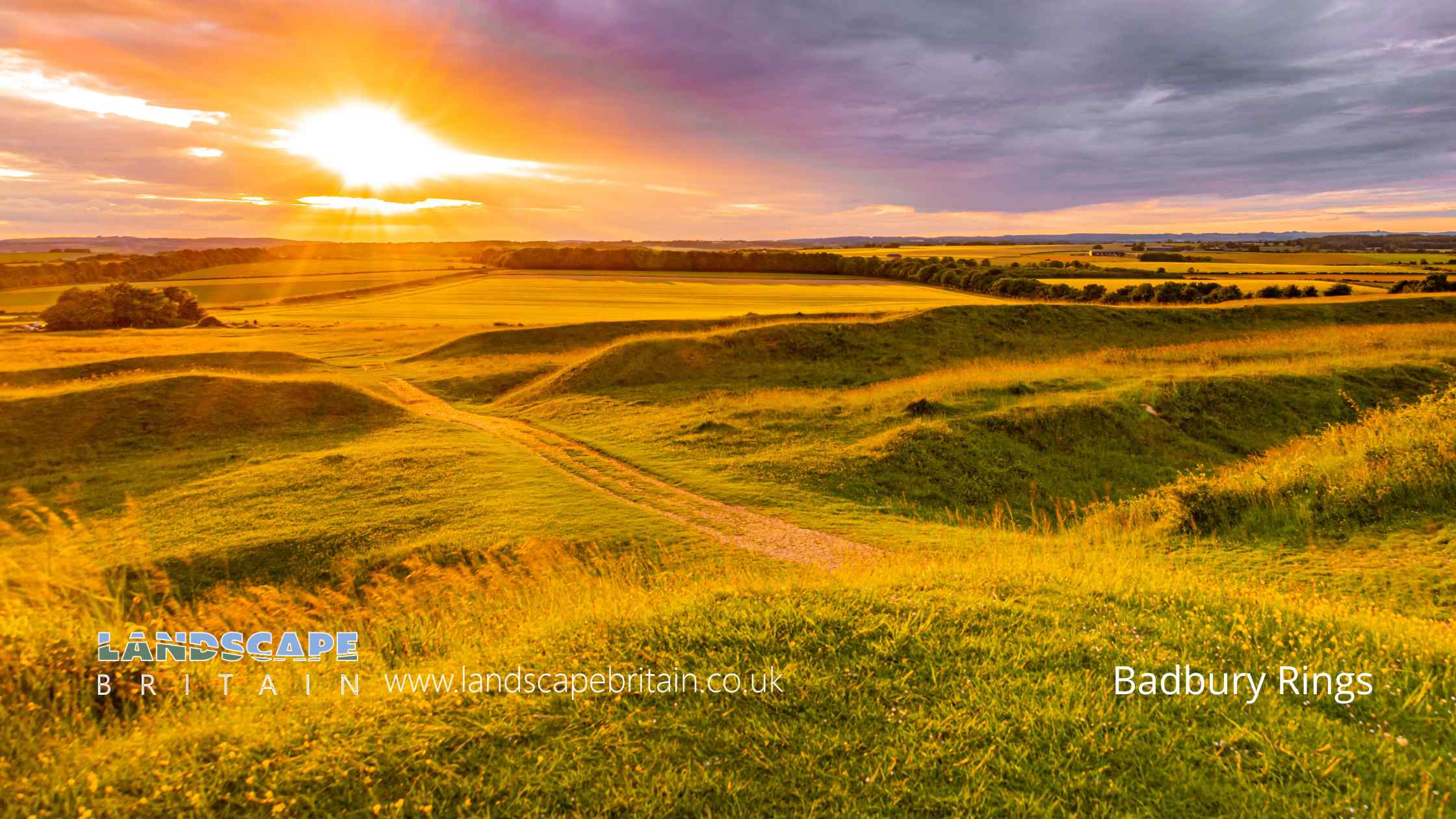
Badbury Rings, located in Dorset, is a significant multivallate hillfort occupying a prominent chalk knoll, offering panoramic views over King Down. This historic site encompasses approximately 20 hectares, distinguished by three substantial ramparts with outer ditches, forming a roughly oval enclosure. The initial construction phase involved the creation of the two inner ramparts, featuring two slightly inturned entrances on the eastern side and an additional inturned entrance to the west, which is safeguarded by a narrow barbican. This barbican was later interrupted by a potentially Roman gap that also cuts through the outer rampart and ditch. The outermost rampart, constructed in a subsequent phase, is less prominent and includes four entrances. Among these, the western entrance is thought to be Roman, while the eastern and southwestern entrances are original, and the southern entrance is of more recent origin.
The site’s historical richness is further evidenced by the field surveys conducted in 1993 and 1998, which revealed a 15-meter wide berm between the middle rampart and ditch. This area is dotted with low mounds and shallow hollows, possibly indicating the locations of ancient buildings. Additionally, an inner quarry ditch trace was noted behind the outer rampart, and up to 28 potential building scoops were identified, particularly concentrated in the southwest quadrant behind the inner rampart. Inside the hillfort, there is another concentric enclosure marked by an irregular scarp. Notable internal features include a hut circle with a banked perimeter and two rectangular dew ponds, recorded to have been in use as late as 1887. Three tree rings, surviving as circular enclosures defined by banks, add to the site’s archaeological intrigue. A compass viewpoint at the summit provides visitors with a strategic vantage point to appreciate the surrounding landscape.
Badbury Rings holds significant historical associations, possibly identified with ‘Vindocladia’ from the Antonine Itinerary and with ‘Mons Badonicus’ as mentioned by Gildas. Its later history is marked by its occupation by Ethelwold’s army around 899 AD and by the ‘Clubmen’ in 1645. In the early 19th century, a prominent fir copse was planted, noted by antiquarian Colt Hoare around 1820. The site has also yielded occasional Roman pottery finds, underscoring its long-standing significance and continuous occupation through various historical periods.
Created: 26 May 2024 Edited: 10 June 2024
Badbury Rings Details
Badbury Rings is a 97 metre high hill in Dorset.
Badbury Rings
Badbury Rings LiDAR Map

Contains public sector information licensed under the Open Government Licence v3.0
Local History around Badbury Rings
There are some historic monuments around including:
Two sections of Roman road on Barrow Hill and Corfe HillsBowl barrow 200m south east of Pimperne Long BarrowTarrant Abbey, site of, and tithe barn at Abbey FarmBowl barrow 400m ESE of Ashley Wood Golf Club HouseRoman buildings N of Witchampton MillRomano-British settlement SW of Badbury RingsLong barrow and a round barrow cemetery at Telegraph Clump on Blandford Race DownRound barrow cemetery in Hyde Hill PlantationRoman camp, forts and a vexillation fortress 240m north of Lake FarmLength of Roman road near King Down FarmBowl barrow on The Cliff 680m NNW of Smith's CottagesDeserted settlement NW of Mountain ClumpTwo bowl barrows and a disc barrow 960m north west and a bowl barrow 880m north west of Crab FarmRound barrow cemetery on Barrow Hill 150m south west of Brookvale FarmRemains of medieval buildings ('Abbey buildings')Bowl barrow 350m south west of Buzbury RingsBowl barrow 620m south east of Langton Lodge FarmBowl barrow 850m ESE of Hill FarmBowl barrow on The Cliff 775m NNW of Smith's CottagesTwo bowl barrows in Ashley Wood 750m SSE of Buzbury RingsBadbury RingsDeer park pale in Stubb's Coppice, Hogstock Coppice and Sing Close CoppiceRound barrow NW of High Lea FarmBowl barrow 550m north east of Field Dairy FarmBowl barrow 850m ENE of LangbourneTwo bowl barrows on Furze Hill, 800m north east of Miller's FarmRemains of medieval standing cross adjacent to St Mary's Church, AlmerEarth circles S of King DownGroup of round barrows NW of Badbury RingsMedieval standing cross 15m south west of St Mary's ChurchSlight univallate hillfort called Crawford CastleRoman building SE of Abbeycroft CoppiceBowl barrow 470m south east of Ashley Wood Golf Club HouseCausewayed enclosure and Iron Age defended settlement with outworks called Buzbury RingsBowl barrow on The Cliff 680m east of Luton FarmMoated site immediately north west of St Mary's ChurchRound barrow cemetery south and west of Rose Lawn Coppice, 600m south west of Higher Merley FarmStraw BarrowSection of Roman road NW of Badbury RingsRoman camp, forts and a vexillation fortress 240m north of Lake FarmWayside cross 130m north of Crawford FarmRound barrow in Buzbury PlantationLength of Roman road on Sovell DownLengths of Roman road in Norwood Coppice and in The RookeryTwo bowl barrows at the south west corner of Pond Bottom Plantation, 1480m and 1520m NNW of Down BarnSite of the medieval manor house and associated buildings of Kingston LacyLong barrow and two bowl barrows 140m north west of Dormy HouseThe Henbury Barrow, a bowl barrow 800m west of Henbury HallBowl barrow 80m west of Dormy HouseRomano-British settlement and two bowl barrows on Blandford Race Down 450m south east of Telegraph ClumpA shrunken medieval village and earlier prehistoric settlement remains at Walnut Tree FieldLong barrow 820m south east of Telegraph ClumpWindmill Barrow, a bowl barrow 40m south west of Windmill Barrow FarmCross-ridge dyke on Rawston DownLength of Roman road on Eye MeadMound on The LeazeBowl barrow 350m north of Naked CrossSection of Roman road near Badbury RingsPimperne Long BarrowTwo bowl barrows 760m north east of Miller's FarmBowl barrow 800m ESE of Hill FarmTwo Late Iron Age or Romano-British enclosed settlements with part of an associated field system 420m NNW of South FarmRound barrow cemetery 400m and 500m south east of Hyde Hill PlantationRoman enclosure on Keyneston DownGroup of round barrows on King DownThe Leaze medieval siteBradford BarrowRoman fort at Crab FarmPillow mound 80m south east of Windmill Barrow Farm.


